Marble Hill–225th Street (IRT Broadway–Seventh Avenue Line)
| Marble Hill–225th Street | |||||||
|---|---|---|---|---|---|---|---|
| New York City Subway rapid transit station | |||||||
|
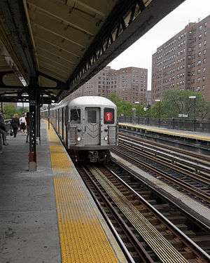
View of southbound train from platform | |||||||
| Station statistics | |||||||
| Address |
West 225th Street & Broadway New York, NY 10463 | ||||||
| Borough | Manhattan | ||||||
| Locale | Marble Hill | ||||||
| Coordinates | 40°52′26″N 73°54′36″W / 40.874°N 73.91°WCoordinates: 40°52′26″N 73°54′36″W / 40.874°N 73.91°W | ||||||
| Division | A (IRT) | ||||||
| Line | IRT Broadway–Seventh Avenue Line | ||||||
| Services |
1 | ||||||
| Transit connections |
| ||||||
| Structure | Elevated | ||||||
| Platforms | 2 side platforms | ||||||
| Tracks | 3 (2 in regular service) | ||||||
| Other information | |||||||
| Opened | January 14, 1907 | ||||||
| Traffic | |||||||
| Passengers (2015) |
1,809,998[1] | ||||||
| Rank | 270 out of 422 | ||||||
| Station succession | |||||||
| Next north |
231st Street: 1 | ||||||
| Next south |
215th Street: 1 221st Street: no regular service (demolished) | ||||||
| |||||||
| |||||||


Marble Hill–225th Street is a local station on the IRT Broadway–Seventh Avenue Line of the New York City Subway. Located at the intersection of Broadway and 225th Street in Marble Hill, Manhattan, it is served by the 1 train at all times. It is the northernmost subway station in Manhattan, although it is not located on Manhattan Island itself.
History
The West Side Branch of the original subway line was extended to 225th Street on January 14, 1907, the structure of the 221st Street was dismantled and was moved to 230th Street for a new temporary terminus.[2] This station stopped being the terminal of the line, when on January 27, 1907, the line was extended to the new temporary terminal at 230th Street.
In 1948, platforms on the IRT Broadway–Seventh Avenue Line from 103rd Street to 238th Street were lengthened to 514 feet to allow full ten-car express trains to platform. Previously the stations could only platform six car local trains. The platform extensions were opened in stages. On July 9, 1948, the platform extensions at stations between 207th Street and 238th Street were opened for use at the cost of $423,000.[3][4]
Station layout
| P Platform level |
Side platform, doors will open on the right | |
| Northbound local | ← | |
| Peak-direction express | → No regular service | |
| Southbound local | → | |
| Side platform, doors will open on the right | ||
| M | Mezzanine | to entrances/exits, station agent, MetroCard vending machines |
| G | Street Level | Entrances/Exits |
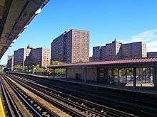
This elevated station has three tracks and two side platforms. The center track is not used in revenue service. The southern half of the platforms has beige windscreens and red canopies with green frames and support columns while the northern half has black, steel, waist high fences and lampposts. The station signs are in the standard black name plates in white lettering.
The 1991 artwork here, by Wopo Holup, is called Elevated Nature I-IV. Portions are also located at four other stations on this line.
Exits and station houses
All fare control areas are at platform level and there are no crossovers or crossunders. Both platforms have a station house, but only the southbound one is active. It has a turnstile bank, token booth, and one staircase going down to 225th Street and the northwest corner of Broadway. Access to and from the northbound platform is via two full-height turnstiles, one exit-only and the other entry-exit, and one staircase going down to the east side of Broadway across from the northwest corner of 225th Street.[5]
Location

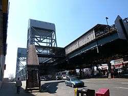
This station is less than a 0.2-mile (0.32 km) walk from the Marble Hill station on Metro-North Railroad's Hudson Line. Just south of the station, the IRT Broadway–Seventh Avenue Line crosses the Broadway Bridge onto the island of Manhattan.
This station today and the neighborhood it serves reside on the north shore of the Harlem River Ship Canal, also known as Spuyten Duyvil Creek, and are thus geographically on the mainland. However, the neighborhood was formerly part of the island of Manhattan. The canal was constructed in 1895, separating the neighborhood from the rest of the island. After the original creek bed was filled in, Marble Hill became part of the mainland, although it is still considered part of Manhattan for administrative and political purposes.[note 1][6]
Notes
References
- ↑ "Facts and Figures: Annual Subway Ridership". Metropolitan Transportation Authority. Retrieved 2016-04-19.
- ↑ "Farthest North In Town By The Interborough: Take a Trip to the New Station, 225th Street West". New York Times. January 14, 1907. Retrieved 16 August 2015.
- ↑ Report for the three and one-half years ending June 30, 1949. New York City Board of Transportation. 1949.
- ↑ "MORE LONG PLATFORMS; Five Subway Stations on IRT to Accommodate 10-Car Trains". The New York Times. 1948-07-10. ISSN 0362-4331. Retrieved 2016-03-27.
- ↑ "MTA Neighborhood Maps: Riverdale" (PDF). mta.info. Metropolitan Transportation Authority. 2015. Retrieved 15 September 2015.
- ↑ Tax Block & Tax Lot Base Map Files on CD-ROM, New York City Department of City Planning. Accessed July 26, 2007. "Marble Hill is a neighborhood that is part of the borough of Manhattan but is administratively often included with neighboring areas of the Bronx. Parts of Marble Hill are within Bronx Community District 7; the rest is within Bronx Community District 8."
External links
| Wikimedia Commons has media related to Marble Hill – 225th Street (IRT Broadway – Seventh Avenue Line). |
- nycsubway.org – IRT West Side: 225th Street
- Station Reporter – 1 Train
- The Subway Nut – Marble Hill–225th Street Pictures
- 225th Street (North) entrance from Google Maps Street View
- 225th Street (South) entrance from Google Maps Street View
- Platforms from Google Maps Street View