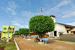
Marechal Thaumaturgo
Coordinates: 08°56′27″S 72°47′31″W / 8.94083°S 72.79194°W
| Marechal Thaumaturgo | |
|---|---|
 | |
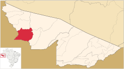 Location of municipality in Acre State | |
 Marechal Thaumaturgo Location in Brazil | |
| Coordinates: 08°56′27″S 72°47′31″W / 8.94083°S 72.79194°W | |
| Country |
|
| State | Acre |
| Area | |
| • Total | 2,990 sq mi (7,744 km2) |
| Population (2007) | |
| • Total | 13 061 |
Marechal Thaumaturgo is a municipality located in the west of the Brazilian state of Acre. Its population is 13 061 and its area is 7,744 km².
The municipality contains 5% of the 846,633 hectares (2,092,080 acres) Serra do Divisor National Park, created in 1989.[1] It contains 5% of the Alto Tarauacá Extractive Reserve, created in 2000.[2]
Climate
| Climate data for Marechal Thaumaturgo | |||||||||||||
|---|---|---|---|---|---|---|---|---|---|---|---|---|---|
| Month | Jan | Feb | Mar | Apr | May | Jun | Jul | Aug | Sep | Oct | Nov | Dec | Year |
| Average high °C (°F) | 31.1 (88) |
30.7 (87.3) |
30.8 (87.4) |
30.9 (87.6) |
30.8 (87.4) |
30.6 (87.1) |
31.0 (87.8) |
32.4 (90.3) |
32.5 (90.5) |
32.1 (89.8) |
31.5 (88.7) |
31.3 (88.3) |
31.31 (88.35) |
| Daily mean °C (°F) | 26.3 (79.3) |
26.1 (79) |
26.0 (78.8) |
26.1 (79) |
25.6 (78.1) |
24.8 (76.6) |
24.7 (76.5) |
25.8 (78.4) |
26.3 (79.3) |
26.6 (79.9) |
26.4 (79.5) |
26.4 (79.5) |
25.92 (78.66) |
| Average low °C (°F) | 21.6 (70.9) |
21.5 (70.7) |
21.3 (70.3) |
21.3 (70.3) |
20.5 (68.9) |
19.1 (66.4) |
18.5 (65.3) |
19.2 (66.6) |
20.2 (68.4) |
21.2 (70.2) |
21.4 (70.5) |
21.5 (70.7) |
20.61 (69.1) |
| Average precipitation mm (inches) | 203 (7.99) |
201 (7.91) |
234 (9.21) |
163 (6.42) |
99 (3.9) |
42 (1.65) |
32 (1.26) |
51 (2.01) |
77 (3.03) |
101 (3.98) |
201 (7.91) |
197 (7.76) |
1,601 (63.03) |
| Source: http://en.climate-data.org/location/32412/ | |||||||||||||
References
- ↑ PARNA da Serra do Divisor (in Portuguese), ISA: Instituto Socioambiental, retrieved 2016-08-08
- ↑ RESEX do Alto Tarauacá (in Portuguese), ISA: Instituto Socioambiental, retrieved 2016-08-07

This article is issued from Wikipedia - version of the 8/8/2016. The text is available under the Creative Commons Attribution/Share Alike but additional terms may apply for the media files.