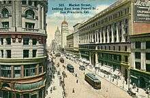
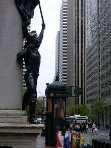
Market Street (San Francisco)
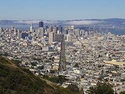
Market Street is a major thoroughfare in San Francisco, California. It begins at The Embarcadero in front of the Ferry Building at the northeastern edge of the city and runs southwest through downtown, passing the Civic Center and the Castro District, to the intersection with Corbett Avenue in the Twin Peaks neighborhood. Beyond this point, the roadway continues as Portola Drive into the southwestern quadrant of San Francisco. Portola Drive extends south to the intersection of St. Francis Boulevard and Sloat Boulevard, where it continues as Junipero Serra Boulevard.
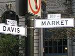
Market Street is the boundary of two street grids. Streets on its southeast side are parallel or perpendicular to Market Street, while those on the northwest are nine degrees off from the cardinal directions.
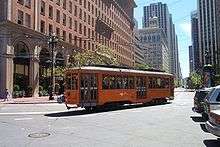
Market Street is a major transit artery for the city of San Francisco, and has carried in turn horse-drawn streetcars, cable cars, electric streetcars, electric trolleybuses, and diesel buses. Today Muni's buses, trolleybuses, and heritage streetcars (on the F Market line) share the street, while below the street the two-level Market Street Subway carries Muni Metro and Bay Area Rapid Transit (BART). While cable cars no longer operate on Market Street, the surviving cable car lines terminate to the side of the street at its intersections with California Street and Powell Street.
History
Market Street cuts across the city for three miles (4.8 km) from the waterfront to the hills of Twin Peaks. It was laid out originally by Jasper O'Farrell, a 26-year-old trained civil engineer who emigrated to Yerba Buena. The town was renamed San Francisco in 1847 after it was captured by United States troops during the Mexican-American War. O'Farrell first repaired the original layout of the settlement around Portsmouth Square and then established Market Street as the widest street in town: 120 feet (37 m) between property lines. (Van Ness Avenue now beats it, at 125 feet (38 m) wide.) It was described at the time as an arrow aimed straight at "Los Pechos de la Chola" (the Breasts of the Maiden), now called Twin Peaks. Writing in Forgotten Pioneers, T.F. Pendergast wrote:
"When the engineer had completed his map of Market Street and the southern part of the city, what was regarded as the abnormal width of the proposed street excited part of the populace, and an indignation meeting was held to protest against the plan as wanton disregard for rights of landowners; and the mob, for such it was, decided for lynch law. A friend warned O'Farrell, before the crowd had dispersed. He rode with all haste to North Beach, took a boat for Sausalito, and thence put distance behind him on fast horses in relay until he reached his retreat in Sonoma. He found it discreet to remain some time in the country before venturing to return to the city."
At the time, the Market Street right-of-way was blocked by a sixty-foot sand dune where the Palace Hotel is now located, and a hundred yards further west stood a second sand hill nearly ninety feet tall. The city soon filled in the ground between Portsmouth Square and Happy Valley at First and Mission Street. The dunes were leveled and the sand used for fill.
The first horsecar-powered railway line to open in San Francisco commenced running down the thoroughfare on July 4, 1860, operating under the Market Street Railroad Company.[1] By 1918 Muni was in direct competition with the United Railroads of San Francisco (the successor company to the Market Street RailRoad Company) down the length of Market Street; the two operators each operated their own pair of rail tracks down that thoroughfare, which came to be known as the 'roar of the four'. The two Union Railroad tracks were on the inside and the two San Francisco Municipal Railway tracks were on the outside.[1][2]
In 1892 The Owl Drug Company was established at 1128 Market Street and later grew into a leading American drugstore retailer.[3]
Reconstruction
Market Street underwent major changes in the late 1960s and early 1970s, when Muni Metro service was moved underground in concert with the development of the Bay Area Rapid Transit system. Construction of the Market Street Subway commenced in July 1967. Prolonged disruption to what had traditionally been the social and economic center of the city contributed to the decline of the mid-Market shopping district in later years.[4] In 1980, Muni's surface operations were partially routed underground with full service changes occurring in 1982. While there were initially no plans to retain the surface tracks, several Historic Trolley Festivals had proven popular enough to reinstate operations in the form of the F Market historic streetcar line.
Festivities
Market Street parades have long marked global events, such as the Panama-Pacific International Exposition, the Preparedness Day bombing of 1916, the parade of the influenza-masked revelers of the first Armistice Day, the 1934 general strike that paralyzed the ports of the Pacific Coast, and the end of World War II. In the days of the first United Nations conferences, Anthony Eden, Molotov, Stettinius, and Bidault rode up Market Street, waving to the crowds of hopefuls.
On Christmas Eve 1910, opera singer Luisa Tetrazzini (for whom the dish Tetrazzini was named) sang a free outdoor concert to a crowd some estimated at 250,000, following a dispute with Oscar Hammerstein.[5] Another historic Market Street event was the New Year's Eve celebration at the Ferry Building on December 31, 1999. Over 1.2 million people jammed Market Street and nearby streets for the raucous and peaceful turn-of-the-century celebration. The San Francisco Gay Pride parade runs down Market Street, attracting many people every year.
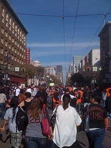
Victory parades celebrating the San Francisco Giants' World Series titles were held on Market Street in 2010, 2012, and 2014.
Redevelopment
Central Market Community Benefit District[6] extends from Fifth to Ninth Streets,[7] and is considered part of either the "Mid Market" or "South of Market" areas.
On September 29, 2009, traffic-calming efforts took effect for a six-week test in which private automobiles would be restricted in travelling east from Sixth Street towards the Ferry Building. All eastbound traffic will be encouraged to turn right onto 10th Street and then required to do so at 8th Street. Eastbound traffic entering Market from Seventh Street will be required to exit Market at Sixth. These traffic calming efforts are following recent urban planning trends seeking to make streets safer and more pleasant. Drivers failing to comply would face fines.[8] These changes were later made permanent.[9] Planning efforts are currently underway to ban private automobiles from Market Street altogether between Franklin and Steuart Streets, in order to provide a better environment for transit, cyclists, and pedestrians.[10] On August 11, 2015, the city banned private vehicles from turning onto Market Street between Third and Eighth Streets.[11]
In December 2013, the city launched free wi-fi internet access along Market Street.[12]
See also
References
- 1 2 Market Street Railway (2004). A Brief History of Market St. Railway. Retrieved September 23, 2005. Section The Market Street Railroad Company, 1860-1882 Archived September 21, 2005, at the Wayback Machine.
- ↑ Robert Callwell and Walter Rice (2000). Of Cables and Grips: The Cable Cars of San Francisco. Published by the Friends of the Cable Car Museum. ISBN unknown.
- ↑ "The Owl Drug Company". Bergsengs.com. Retrieved 10 August 2014.
- ↑ Carlsson, Chris (March 23, 2009). "Will We Ever Get Market Street Right?". Streetsblog San Francisco. Retrieved 2015-09-09.
- ↑ Carl Nolte (December 24, 2010). "Luisa Tetrazzini's gift ends S.F. era on high note". San Francisco Chronicle.
- ↑ "Central Market Community Benefit District". Central Market Community Benefit District.
- ↑ "Central Market Community Benefit District". central-market.org.
- ↑ Market Street traffic experiment starts Tuesday, San Francisco Chronicle
- ↑ "Market Street Right Turns Made Permanent by SFMTA Board". SF Streetsblog.
- ↑ Cabanatuan, Michael (20 June 2012). "S.F. Market Street car ban urged by city agencies". San Francisco Chronicle. Retrieved 23 August 2012.
- ↑ Cabanatuan, Michael (9 August 2015). "Turns onto Market Street by private cars barred starting Tuesday". San Francisco Chronicle. Retrieved 9 August 2015.
- ↑ Susan Crawford; et al. (2014), Community Fiber in Washington, D.C., Seattle, WA, and San Francisco, CA: Developments and Lessons Learned, Berkman Center Research Publication (2014-9) – via Social Science Research Network
External links
![]() Media related to Market Street, San Francisco at Wikimedia Commons
Media related to Market Street, San Francisco at Wikimedia Commons
| Previous state: Terminus |
California | Next state: California |
| Numbered streets |
|  |
|---|---|---|
| North–south streets | ||
| East–west streets | ||
| Diagonal streets | ||
| Alleyways | ||