Markha River (India)

The Markha River is a river in Ladakh, India. It is a tributary of the Zanskar River and starts at the junction of the Langtang Chu and Nimaling Chu. Villages along the river valley include Skiu (Skyu), Markha, Umlung and Hangkar (Hankar).[1] The Markha River lies within Hemis National Park.[2]
The Markha Valley is one of the most popular trekking routes in Ladakh,[3] accessible from Ganda La pass near Spituk in the west, which is usually the beginning point of the trek,[4] and Gongmaru La pass near Hemis,[5] where the trek usually ends.[4]
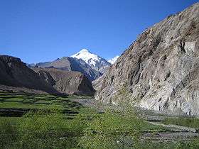
Towards the head of the valley you can find the Kang Yatze, a 6,400-metre-high (21,000 ft) mountain. The Markha River also passes to the south of the Stok range which includes the 6,153-metre-high (20,187 ft) Stok Kangri mountain.[1]
Nomadic families herd their yaks in this valley. Many small monasteries exist, of which Tache gompa is the most important Buddhist monastery in the Markha valley.
References
- 1 2 Partha S Banerjee (2016). Ladakh and Zanskar Trekking Map (Map). 1:175,000. Milestone Himalayan Series. Kolkata: Milestone Books. ISBN 978-81-903270-9-1.
- ↑ "Hemis National Park on Google Maps". Retrieved 2016-10-28.
- ↑ Kucharski, Radek (2012). Trekking in Ladakh (1st ed.). Cicerone. p. 325. ISBN 978 1 85284 675 6.
- 1 2 "The 4 Coolest Treks in Ladakh". AlienAdv Blog. Retrieved 2015-11-30.
- ↑ Jina, Prem Singh (1994-01-01). Tourism in Ladakh Himalaya. Indus Publishing. ISBN 9788173870040.
External links
| Wikimedia Commons has media related to Markha. |
Coordinates: 34°00′11″N 77°12′42″E / 34.00306°N 77.21167°E