Maromokotra
| Maromokotra | |
|---|---|
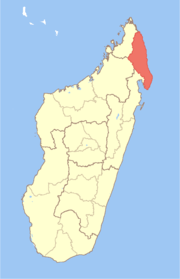
 Maromokotra Location in Madagascar | |
| Coordinates: 12°57′S 49°34′E / 12.950°S 49.567°E | |
| Country |
|
| Region | Sava |
| District | Vohemar |
| Elevation[1] | 172 m (564 ft) |
| Population (2001)[2] | |
| • Total | 4,000 |
| Time zone | EAT (UTC3) |
Maromokotra is a town and commune (Malagasy: kaominina) in northern Madagascar. It is situated at the unpaved Route Nationale 5a halfway between Ambilobe and Daraina, near the Saharenana River. It belongs to the district of Vohemar, which is a part of the Sava Region. The population of the commune was estimated to be approximately 4,000 in the 2001 commune census.[2]
Only primary schooling is available. The majority (94%) of the population of the commune are farmers. The most important crop is rice, while other important products are banana, maize and seeds of catechu. Services provide employment for 1% of the population, and fishing employs the remaining 5% of the population.[2]
References and notes
- ↑ Estimated based on DEM data from Shuttle Radar Topography Mission
- 1 2 3 "ILO census data". Cornell University. 2002. Retrieved 2008-02-27.
Coordinates: 12°57′S 49°34′E / 12.950°S 49.567°E