Maryland Route 300
| ||||
|---|---|---|---|---|
|
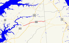
Maryland Route 300 highlighted in red | ||||
| Route information | ||||
| Maintained by MDSHA | ||||
| Length: |
13.55 mi[1] (21.81 km) 2 sections | |||
| Existed: | 1927 – present | |||
| Major junctions | ||||
| West end: |
| |||
|
| ||||
| East end: |
| |||
| Location | ||||
| Counties: | Queen Anne's | |||
| Highway system | ||||
| ||||

Maryland Route 300 (MD 300) is a state highway in the U.S. state of Maryland. Known for most of its length as Sudlersville Road, the highway runs 13.55 miles (21.81 km) from MD 213 in Church Hill east through Sudlersville to the Delaware state line, where the highway continues as Delaware Route 300 (DE 300). Together with DE 300, DE 44, and DE 8, MD 300 forms the primary east–west connection between U.S. Route 301 (US 301) in northern Queen Anne's County and Dover, Delaware. MD 300 between Church Hill and Dudley Corners was one of the original state roads marked for improvement in 1909. The highway was completed between Church Hill and Sudlersville around 1920. MD 300 between Sudlersville and the Delaware state line was constructed in the late 1920s and early 1930s.
Route description
MD 300 begins at an intersection with MD 213 (Church Hill Road) in Church Hill. The highway heads east as two-lane Sudlersville Road and intersects MD 19 (Main Street) before leaving the town and heading northeast through farmland. The state highway intersects US 301 (Blue Star Memorial Highway) at a superstreet intersection.[1][2] Traffic on MD 300 is required to turn right onto US 301, perform a U-turn, then turn right again to continue on MD 300. The highway continues northeast before curving east at the crossing of Red Lion Branch and intersecting MD 290 (Crumpton Road) and Benton Corners Road at Dudley Corners, which is the site of historic Dudley's Chapel.
MD 300 heads east to the town of Sudlersville, where the highway's name changes to Main Street. The highway intersects MD 837 (Church Circle) and MD 313 (Church Street) before crossing the Centreville Branch of the Northern Line of the Maryland and Delaware Railroad. MD 300 becomes Sudlersville Road again upon leaving the town. The highway crosses Unicorn Branch, intersects Duhamel Corner Road and Peters Corner Road, and crosses Andover Branch. MD 300 curves to the northeast at Busic Church Road to its eastern terminus at the Delaware state line, where Sudlersville Road continues east as DE 300. A short distance east of the state line at Everetts Corner, the highway intersects DE 44, which leads to DE 8 and Dover. DE 300 heads east from there toward Kenton and Smyrna.[1][3]
MD 300 is officially separated into two sections by the US 301 superstreet intersection; MD 300 runs east of US 301 and MD 300A is the portion west of the U.S. Highway. The portion of the highway from US 301 to the Delaware state line is a part of the National Highway System.[4]
History
The portion of MD 300 between Church Hill and Dudley Corners was designated one of the original state roads, as part of a connection to Crumpton, by the Maryland State Roads Commission in 1909.[5][6] In 1915, no work on this segment had begun, but by then it was no longer considered a necessary part of the statewide road system.[7] The first segment of MD 300 was a 9-foot-wide (2.7 m) macadam state-aid road built between Dudley Corners and Sudlersville by 1910.[5][7] The link between Church Hill and Dudley Corners was completed as a 15-foot-wide (4.6 m) concrete state-aid road between 1919 and 1921.[8][9] The portions of the Church Hill–Sudlersville road narrower than 15 feet (4.6 m) were widened to this width with macadam shoulders by 1926.[10]
The portion of MD 300 between Sudlersville and the Delaware state line was started in 1926; the paving of Main Street in concrete from MD 313 to the railroad crossing within Sudlersville was completed in 1927.[10][11] The concrete highway was extended to Duhamel Corner Road in 1928 and to Peters Corner Road in 1930.[12][13] MD 300 was marked along the length of Sudlersville Road when it was completed to the state line between 1930 and 1933.[6][14] When MD 213's bypass of Church Hill was completed in 1971, MD 300 was extended west to its present terminus.[15] MD 300A was designated along the portion of MD 300 west of US 301 when the superstreet intersection between the two highways was installed in 2005.[16]
Junction list
The entire route is in Queen Anne's County.
| Location | mi [1] | km | Destinations | Notes | |
|---|---|---|---|---|---|
| Church Hill | 0.00 | 0.00 | Western terminus of MD 300A | ||
| 0.16 | 0.26 | ||||
| | 3.92 | 6.31 | Superstreet intersection; eastern terminus of MD 300A; western terminus of MD 300 | ||
| Dudley Corners | 5.52 | 8.88 | |||
| Sudlersville | 7.28 | 11.72 | |||
| 7.34 | 11.81 | ||||
| | 13.55 | 21.81 | Eastern terminus of MD 300; Delaware state line | ||
| 1.000 mi = 1.609 km; 1.000 km = 0.621 mi | |||||
See also
 Maryland Roads portal
References
- 1 2 3 4 Highway Information Services Division (December 31, 2013). Highway Location Reference. Maryland State Highway Administration. Retrieved 2012-11-03.
- Queen Anne's County (PDF)
- ↑ Google (2010-09-28). "Maryland Route 300A" (Map). Google Maps. Google. Retrieved 2010-09-28.
- ↑ Google (2010-09-28). "Maryland Route 300" (Map). Google Maps. Google. Retrieved 2010-09-28.
- ↑ National Highway System: Maryland (PDF) (Map). Federal Highway Administration. October 1, 2012. Retrieved 2012-11-03.
- 1 2 Maryland Geological Survey (1910). Map of Maryland (Map). Baltimore: Maryland Geological Survey.
- 1 2 Uhl, G. Clinton; Bruce, Howard; Shaw, John K. (October 1, 1930). Report of the State Roads Commission of Maryland (1927–1930 ed.). Baltimore: Maryland State Roads Commission. p. 225. Retrieved 2010-09-28.
- 1 2 Weller, O.E.; Parran, Thomas; Miller, W.B.; Perry, John M.; Ramsay, Andrew; Smith, J. Frank (May 1916). Annual Reports of the State Roads Commission of Maryland (1912–1915 ed.). Baltimore: Maryland State Roads Commission. pp. 54, 124. Retrieved 2010-09-28.
- ↑ Zouck, Frank H.; Uhl, G. Clinton; Mudd, John F. (January 1920). Annual Reports of the State Roads Commission of Maryland (1916–1919 ed.). Baltimore: Maryland State Roads Commission. p. 47. Retrieved 2010-09-28.
- ↑ Maryland Geological Survey (1921). Map of Maryland: Showing State Road System and State Aid Roads (Map). Baltimore: Maryland Geological Survey.
- 1 2 Mackall, John N.; Darnall, R. Bennett; Brown, W.W. (January 1927). Annual Reports of the State Roads Commission of Maryland (1924–1926 ed.). Baltimore: Maryland State Roads Commission. pp. 33, 95. Retrieved 2010-09-28.
- ↑ Maryland Geological Survey (1927). Map of Maryland: Showing State Road System and State Aid Roads (Map). Baltimore: Maryland Geological Survey.
- ↑ Maryland Geological Survey (1928). Map of Maryland: Showing State Road System and State Aid Roads (Map). Baltimore: Maryland Geological Survey.
- ↑ Maryland Geological Survey (1930). Map of Maryland Showing State Road System: State Aid Roads and Improved County Road Connections (Map). Baltimore: Maryland Geological Survey.
- ↑ Maryland Geological Survey (1933). Map of Maryland Showing State Road System: State Aid Roads and Improved County Road Connections (Map). Baltimore: Maryland Geological Survey.
- ↑ Maryland State Roads Commission (1971). Maryland: Official Highway Map (Map). Baltimore: Maryland State Roads Commission.
- ↑ Highway Information Services Division (December 31, 2005). Highway Location Reference. Maryland State Highway Administration. Retrieved 2010-09-28.
- Queen Anne's County (PDF)