Maryland Route 312
| ||||
|---|---|---|---|---|
|
Maryland Route 312 highlighted in red | ||||
| Route information | ||||
| Maintained by MDSHA | ||||
| Length: | 11.41 mi[1] (18.36 km) | |||
| Existed: | 1927 – present | |||
| Major junctions | ||||
| South end: |
| |||
|
| ||||
| North end: |
| |||
| Location | ||||
| Counties: | Caroline | |||
| Highway system | ||||
| ||||

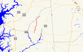
Maryland Route 312 (MD 312) is a state highway in the U.S. state of Maryland. The state highway runs 11.41 miles (18.36 km) from MD 404 near Ridgely north to MD 313 at Baltimore Corner. MD 312 traverses northwestern Caroline County, connecting Ridgely with Bridgetown. The highway's first section was paved around Ridgely in the 1910s. The highway was completed from MD 404 to Ridgely in the mid-1920s and from north of Ridgely to Baltimore Corner in the late 1920s.
Route description
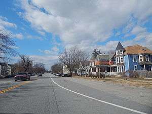
MD 312 begins at an intersection with MD 404 (Shore Highway) between Hillsboro and Denton. The roadway continues south as county-maintained Log Cabin Road. MD 312 heads north as two-lane Downes Station Road, passing through farmland until it curves to the east and meets MD 480 (Ridgely Road) on a tangent, joining that highway in a concurrency. After MD 776 (Sunset Boulevard), the old alignment of MD 312, splits to the north, MD 312 and MD 480 enter the town of Ridgely and the highway's name changes to Sixth Street. MD 312 leaves MD 480 by turning north onto Central Avenue, a two-lane street with very wide shoulders used for angle or perpendicular parking. The state highway intersects an abandoned rail line after meeting the other end of MD 776 (Railroad Avenue). MD 312 leaves the town of Ridgely shortly after passing Ridgely Elementary School. The state highway continues north through farmland as Oakland Road, passing by Ridgely Airpark and through the hamlet of Oakland. MD 312 intersects MD 304 (Bridgetown Road) in Bridgetown and passes through a forested area before reaching its northern terminus at MD 313 (Goldsboro Road) at Baltimore Corner.[1][2]
History
The first section of MD 312 was paved through Ridgely and north about 1 mile (1.6 km) toward Oakland by 1921.[3] That highway was extended to Oakland by 1923.[4] The state highway was constructed between MD 404 at Long's School House Corner and Ridgely in 1924 and 1925.[5][6] The remainder of the highway through Bridgetown to MD 313 at Baltimore Corner was constructed between 1926 and 1929.[5][7][8] MD 312 originally followed Sunset Boulevard and Railroad Avenue through Ridgely, rejoining the present route at Railroad Avenue's intersection with Central Avenue, which headed south as MD 480.[9] In 1953, Sixth Street was completed between Sunset Boulevard and Central Avenue. MD 312 and MD 480, which was later extended west to Hillsboro, were assigned to the new road and MD 312 replaced MD 480 on Central Avenue.[10][11]
Junction list
The entire route is in Caroline County.
| Location | mi [1] | km | Destinations | Notes | |
|---|---|---|---|---|---|
| | 0.00 | 0.00 | Southern terminus | ||
| Ridgely | 1.42 | 2.29 | South end of concurrency with MD 480 | ||
| 1.82 | 2.93 | ||||
| 2.30 | 3.70 | MD 312 turns north onto Central Avenue; north end of concurrency with MD 480 | |||
| 2.71 | 4.36 | ||||
| Bridgetown | 9.09 | 14.63 | |||
| Baltimore Corner | 11.41 | 18.36 | Northern terminus | ||
| 1.000 mi = 1.609 km; 1.000 km = 0.621 mi | |||||
See also
 Maryland Roads portal
References
- 1 2 3 Highway Information Services Division (December 31, 2013). Highway Location Reference. Maryland State Highway Administration. Retrieved 2010-09-03.
- Caroline County (PDF)
- ↑ Google (2010-05-17). "Maryland Route 312" (Map). Google Maps. Google. Retrieved 2010-05-17.
- ↑ Maryland Geological Survey (1921). Map of Maryland: Showing State Road System and State Aid Roads (Map). Baltimore: Maryland Geological Survey.
- ↑ Maryland Geological Survey (1923). Map of Maryland: Showing State Road System and State Aid Roads (Map). Baltimore: Maryland Geological Survey.
- 1 2 Mackall, John N.; Darnall, R. Bennett; Brown, W.W. (January 1927). Annual Reports of the State Roads Commission of Maryland (1924–1926 ed.). Baltimore: Maryland State Roads Commission. pp. 35, 71. Retrieved 2010-09-03.
- ↑ Maryland Geological Survey (1927). Map of Maryland: Showing State Road System and State Aid Roads (Map). Baltimore: Maryland Geological Survey.
- ↑ Uhl, G. Clinton; Bruce, Howard; Shaw, John K. (October 1, 1930). Report of the State Roads Commission of Maryland (1927–1930 ed.). Baltimore: Maryland State Roads Commission. p. 201. Retrieved 2010-09-03.
- ↑ Maryland Geological Survey (1930). Map of Maryland Showing State Road System: State Aid Roads and Improved County Road Connections (Map). Baltimore: Maryland Geological Survey.
- ↑ Maryland State Roads Commission (1939). General Highway Map: State of Maryland (Map). Baltimore: Maryland State Roads Commission.
- ↑ McCain, Russell H.; Bennett, Edgar T.; Kelly, Bramwell (November 12, 1954). Report of the State Roads Commission of Maryland (1953–1954 ed.). Baltimore: Maryland State Roads Commission. p. 152. Retrieved 2010-09-03.
- ↑ Maryland State Roads Commission (1953). Maryland: Official Highway Map (Map). Baltimore: Maryland State Roads Commission.
External links
| Wikimedia Commons has media related to Maryland Route 312. |