Maryland Route 316
| ||||
|---|---|---|---|---|
| Appleton Road | ||||
|
Maryland Route 316 highlighted in red | ||||
| Route information | ||||
| Maintained by MDSHA | ||||
| Length: | 2.67 mi[1] (4.30 km) | |||
| Existed: | 1927 – present | |||
| Major junctions | ||||
| South end: |
| |||
| North end: |
| |||
| Location | ||||
| Counties: | Cecil | |||
| Highway system | ||||
| ||||

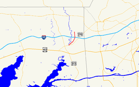
Maryland Route 316 (MD 316) is a state highway in the U.S. state of Maryland. Known as Appleton Road, the highway runs 2.67 miles (4.30 km) from MD 279 in Elkton north to MD 277 in Elk Mills in northeastern Cecil County. MD 316 was constructed in the early 1910s from Elkton to Elk Mills and in early 1920s north of Elk Mills. In the early 1960s, the disjoint northern segment of the highway was transferred to the county and the highway's present southern terminus was established when MD 279 moved to a new alignment north of Elkton in the early 1960s.
Route description

MD 316 begins at an intersection with MD 279 (Elkton Road) in Elkton just north of MD 279's crossing of Big Elk Creek. The two-lane highway heads northeast past Gilpin Manor Memorial Park, on either side of which the highway crosses a tributary of Big Elk Creek. MD 316 intersects Belle Hill Road, curves north, and crosses over Interstate 95 (I-95) (John F. Kennedy Memorial Highway) without access. The highway follows the eastern edge of the Elk Mills Quarry to its northern terminus at MD 277 near Elk Mills. MD 277 heads west as Elk Mills Road and east as Fletchwood Road; Appleton Road continues north as a county highway toward Appleton in the northeast corner of Cecil County.[1][2]
History
The portion of MD 316 between its southern terminus and what is now Belle Hill Road was originally part of MD 279, which continued along Belle Hill Road to its current course.[3] Both the Newark Road and the Barksdale Road, which followed what is now MD 316 north from the Newark Road toward the village of Barksdale north of the Baltimore & Ohio Railroad (B&O Railroad, now CSX's Philadelphia Subdivision), were planned to be built by the state but were instead constructed by Cecil County with state aid. Work on both 14-foot-wide (4.3 m) macadam roads was underway by 1911, and the Barksdale Road was completed to Elk Mills Road by 1915.[4][5] The Barksdale Road was planned to be extended north through the village of Cowenton in 1917, but those plans were cancelled with the United States' entry into World War I.[6] A disjoint segment of the Barksdale Road was built from the B&O Railroad crossing through Barksdale in 1921 and 1922.[7][8] This 0.53-mile-long (0.85 km) segment was transferred from state to county maintenance through a June 29, 1964, road transfer agreement.[9] The southern terminus of MD 316 was moved to its present location after MD 279 was moved to its present course from Big Elk Creek to Belle Hill Road in 1962.[10][11] MD 316 was resurfaced with bituminous concrete in two segments in 1972 and 1973.[12]
Junction list
The entire route is in Cecil County.
| Location | mi[1] | km | Destinations | Notes | |
|---|---|---|---|---|---|
| Elkton | 0.00 | 0.00 | Southern terminus | ||
| Elk Mills | 2.67 | 4.30 | Northern terminus | ||
| 1.000 mi = 1.609 km; 1.000 km = 0.621 mi | |||||
See also
 Maryland Roads portal
References
- 1 2 3 Highway Information Services Division (December 31, 2014). Highway Location Reference. Maryland State Highway Administration. Retrieved July 7, 2016.
- Cecil County (PDF)
- ↑ Maryland State Highway Administration (2015). Maryland General Highway Statewide Grid Map (PDF) (Map). 1:12,000. Baltimore: Maryland State Highway Administration. §§ A16C. Retrieved July 7, 2016.
- ↑ Elkton, MD quadrangle (Map) (1942 ed.). 1:62,500. 15 Minute Series (Topographic). United States Geological Survey.
- ↑ Maryland Geological Survey (1911). Map of Maryland: Showing State Road System and State Aid Roads Completed or Under Construction December 31, 1911 (Map). Baltimore: Maryland Geological Survey.
- ↑ Weller, O.E.; Parran, Thomas; Miller, W.B.; Perry, John M.; Ramsay, Andrew; Smith, J. Frank (May 1916). Annual Reports of the State Roads Commission of Maryland (1912–1915 ed.). Baltimore: Maryland State Roads Commission. pp. 120, 124. Retrieved July 8, 2016.
- ↑ Zouck, Frank H.; Uhl, G. Clinton; Mudd, John F. (January 1920). Annual Reports of the State Roads Commission of Maryland (1916–1919 ed.). Baltimore: Maryland State Roads Commission. p. 44. Retrieved July 8, 2016.
- ↑ Maryland Geological Survey (1923). Map of Maryland: Showing State Road System and State Aid Roads (Map). Baltimore: Maryland Geological Survey.
- ↑ Zouck, Frank H.; Uhl, G. Clinton; Mudd, John F. (January 1920). Annual Reports of the State Roads Commission of Maryland (1916–1919 ed.). Baltimore: Maryland State Roads Commission. p. 75. Retrieved July 8, 2016.
- ↑ "Memorandum of Action of State Roads Commission of Maryland by Chairman and Director John B. Funk" (PDF). S.R.C. Minutes District No. 2 Cecil County. Baltimore: Maryland State Roads Commission. June 29, 1964. Retrieved July 8, 2016 – via Maryland State Archives.
- ↑ Maryland Road Construction Progress Log (PDF). Baltimore: Maryland State Highway Administration. Contract Number: CE-400-8-220 (September 11, 1962). Retrieved July 8, 2016 – via Maryland State Archives.
- ↑ Maryland State Roads Commission (1963). Maryland: Official Highway Map (Map). Baltimore: Maryland State Roads Commission.
- ↑ Maryland Road Construction Progress Log (PDF). Baltimore: Maryland State Highway Administration. Contract Numbers: CE-515-277 (September 2, 1971), CE-531-214 (July 18, 1972). Retrieved July 8, 2016 – via Maryland State Archives.
External links
| Wikimedia Commons has media related to Maryland Route 316. |