Maryland Route 422
| ||||
|---|---|---|---|---|
| Bayard Road | ||||
|
Maryland Route 422 highlighted in red | ||||
| Route information | ||||
| Maintained by MDSHA | ||||
| Length: | 3.04 mi[1] (4.89 km) | |||
| Existed: | 1930 – present | |||
| Major junctions | ||||
| West end: | Polling House Road near Lothian | |||
| East end: |
| |||
| Location | ||||
| Counties: | Anne Arundel | |||
| Highway system | ||||
| ||||

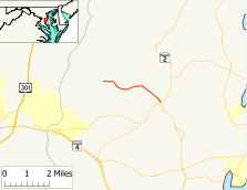
Maryland Route 422 (MD 422) is a state highway in the U.S. state of Maryland. Known as Bayard Road, the highway runs 3.04 miles (4.89 km) from Polling House Road near Lothian east to MD 2 and MD 408 at Lothian in southern Anne Arundel County. MD 422 was constructed in the late 1920s.
Route description
MD 422 begins at Polling House Road west of Lothian. Bayard Road continues west as a county highway through the hamlet of Bayard to Sands Road, which parallels the Patuxent River. MD 422 heads east as a two-lane road through farmland. After passing South Polling House Road, which meets Polling House Road in Harwood, the highway turns southeast toward its terminus at a four-legged roundabout in the village of Lothian. MD 2 (Solomons Island Road) heads southeast toward Prince Frederick and northeast in the direction of Annapolis; MD 408 (Mount Zion-Marlboro Road) heads southwest toward Upper Marlboro.[1][2]
History
MD 422 was constructed as a gravel road in 1929 and 1930 from Polling House Road to Lothian, which was previously known as Mount Zion.[3][4] The Lothian roundabout was installed in 1995.[5]
Junction list
The entire route is in Anne Arundel County.
| Location | mi[1] | km | Destinations | Notes | |
|---|---|---|---|---|---|
| | 0.00 | 0.00 | Bayard Road west / Polling House Road north | Western terminus | |
| Lothian | 3.04 | 4.89 | Eastern terminus; Lothian Roundabout | ||
| 1.000 mi = 1.609 km; 1.000 km = 0.621 mi | |||||
See also
 Maryland Roads portal
References
- 1 2 3 Highway Information Services Division (December 31, 2013). Highway Location Reference. Maryland State Highway Administration. Retrieved 2012-11-24.
- Anne Arundel County (PDF)
- ↑ Google (2012-01-22). "Maryland Route 422" (Map). Google Maps. Google. Retrieved 2012-01-22.
- ↑ Uhl, G. Clinton; Bruce, Howard; Shaw, John K. (October 1, 1930). Report of the State Roads Commission of Maryland (1927–1930 ed.). Baltimore: Maryland State Roads Commission. p. 196. Retrieved 2013-01-20.
- ↑ Maryland Geological Survey (1930). Map of Maryland Showing State Road System: State Aid Roads and Improved County Road Connections (Map). Baltimore: Maryland Geological Survey.
- ↑ Niederhauser, Mike (March 2002). "Modern Roundabouts in Maryland" (PDF). Maryland State Highway Administration. Retrieved 2013-01-22.