Marylebone Lane

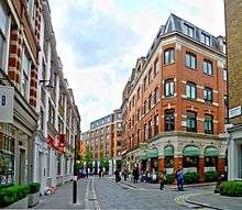

Marylebone Lane is one of the original streets of the Marylebone district of the City of Westminster, London. It runs from Oxford Street in the south to Marylebone High Street in the north, its winding shape following the course of the River Tyburn that it once ran alongside and pre-dating the grid pattern of the other streets in the area. Today the lane is largely composed of small shops, cafes and restaurants with some small apartment blocks. There are some larger commercial buildings at the southern end near Oxford Street.
History
Marylebone Lane dates back to the original medieval village of Tyburn which stood at the south end of the lane near Oxford Street where Stratford Place is now.[1] The lane followed the course of the River Tyburn that once ran south alongside it before crossing Oxford Street,[1] giving the lane a narrow and winding character that is still preserved today[2][3] and making what Tony Aldous called a "rustic diagonal".[4] The Tyburn has since been culverted and enclosed and now runs entirely underground. The area became part of London after it was urbanised using a grid plan in the early 1700s.[4]
Location
Marylebone Lane runs from Oxford Street in the south, where it is now pedestrianised, to the beginning of Marylebone High Street in the north. The junction with Oxford Street was once split into two with a small group of buildings between the two entrances.[5] In the south it is joined by Henrietta Place on its eastern side and crossed by Wigmore Street half way up. Jason Court and Hinde Mews join it on the western side above Wigmore Street and Hinde Street joins it on the west and continues eastwards as Bentinck Street. Bentinck Mews runs off Marylebone Lane on its eastern side and the street is crossed by Bulstrode Street in the north. At its northern end, Bulstrode Place and Cross Keys Close join Marylebone Lane on its eastern side before the lane joins Marylebone High Street.
Character
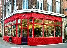
Marylebone Lane is mostly made up of small shops, boutiques, cafes, restaurants and pubs with some small apartment blocks. The haberdashers V.V. Rouleaux are at number 102[6] and The Ivy Cafe at the north end of the lane.[7]
Marylebone Lane has three public houses:
- The Golden Eagle, late Victorian,[1] on the corner with Bulstrode Street.
- The Coach Makers (formerly The Conduit of Tybourne) on the corner with Bentinck Street.
- The Angel in the Fields on the corner with upper Thayer Street.
The southern part of the street includes some larger buildings, such as Debenhams department store which borders the street, and the Radisson Blu Edwardian, Berkshire hotel. The entrance to the Welbeck Street Car Park is in the southern part of Marylebone Lane, adjacent to the London Steinway Hall.[8]
Gallery
-
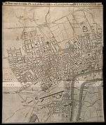
Marylebone Lane (upper left) on a 1764 map when it was on the fringes of London.
-
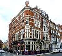
The Coachmakers pub.
-
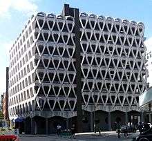
The Welbeck Street Car Park.
References
- 1 2 3 Conservation Area Audit Harley Street City of Westminster, London, 2007. Archived here.
- ↑ Clayton, Antony. ( 2000) Subterranean City: Beneath the Streets of London. London: Historical Publications. p. 33. ISBN 0948667699
- ↑ "Marylebone Lane and High Street" in Christopher Hibbert; Ben Weinreb; John Keay; Julia Keay. (2010). The London Encyclopaedia. London: Pan Macmillan. p. 534. ISBN 978-0-230-73878-2.
- 1 2 Aldous, Tony. (1980) The Illustrated London News Book of London's Villages. London: Secker & Warburg. p. 87. ISBN 0436011506
- ↑ The A to Z of Regency London, London Topographical Society, London, 1985. (Maps originally printed 1799) p. 24. ISBN 0902087193
- ↑ V.V. Rouleaux. Retrieved 20 November 2016.
- ↑ The Ivy Cafe Marylebone. Retrieved 21 November 2016.
- ↑ Steinway & Sons. Retrieved 20 November 2016.
External links
![]() Media related to Marylebone Lane at Wikimedia Commons
Media related to Marylebone Lane at Wikimedia Commons