Massachusetts Route 49
| ||||
|---|---|---|---|---|
| Podunk Pike | ||||
 | ||||
| Route information | ||||
| Maintained by MassDOT | ||||
| Length: | 7.44 mi[1] (11.97 km) | |||
| Existed: | 1972 – present | |||
| Major junctions | ||||
| South end: |
| |||
| North end: |
| |||
| Location | ||||
| Counties: | Worcester | |||
| Highway system | ||||
| ||||

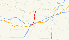
Route 49 is a 7.44 miles (11.97 km) north-south highway located in Worcester County, Massachusetts. For most of its length, the route is known as the Podunk Pike, named for the section of East Brookfield that it passes through. In Spencer and East Brookfield, the route is officially known as the Philip Quinn Memorial Highway.
from Sturbridge
Route description
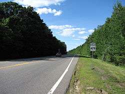
Route 49 is a partially controlled-access highway, having very few intersections and no adjoining properties. Most of the route is a two-lane road with a speed limit of 55 miles per hour (90 km/h).[1]
The route begins at U.S. Route 20 in eastern Sturbridge. The road passes over Interstate 90 (the Mass Pike) about 0.4 miles (0.64 km) north of Route 20, but without an intersection; the nearest access to the Pike is via I-84 to the west. It then clips a small corner of the town of Charlton[2] before continuing through the northeast corner of Sturbridge into East Brookfield. The road crosses just two roads in that town before entering the town of Spencer. The road crosses the Sevenmile River before ending at Route 9, about 1.5 miles (2.4 km) west of that town's center.
Major Intersections
The entire route is in Worcester County.
| Location | mi[1] | km | Destinations | Notes | |
|---|---|---|---|---|---|
| Sturbridge | 0.0 | 0.0 | South end of Route 49 | ||
| Spencer | 7.4 | 11.9 | North end of Route 49 | ||
| 1.000 mi = 1.609 km; 1.000 km = 0.621 mi | |||||
References
| Wikimedia Commons has media related to Massachusetts Route 49. |
- 1 2 3 "Massachusetts Route Log Applicaton". Massachusetts Department of Transportation. Retrieved September 24, 2016.
- ↑ Massachusetts Atlas & Gazetteer, Second Edition. Yarmouth, Maine: DeLorme, 2002, p. 48.