Maunu, New Zealand
| Maunu | |
|---|---|
| Basic information | |
| Local authority | Whangarei |
| Population | 1,359 (2013) |
| Postcode(s) | 0110 |
| Surrounds | |
| Northeast | Horahora |
| East | Raumanga |
| West | Maungatapere |
Maunu is a suburb to the south west of Whangarei in Northland, New Zealand. A volcanic hill to the west is also called Maunu and has a peak 395 m above sea level. State Highway 14 runs through the suburb.[1]
The population was 1,359 in the 2013 Census, an increase of 57 from 2001.[2]
Education
Pompallier Catholic College is a secondary (years 7-13) school with a decile rating of 7 and a roll of 560.[3] It was founded in 1971 as a private boys' boarding school but became coeducational in 1977. In 1981 it closed the boarding facilities and became state integrated.[4]
Maunu School is a contributing primary (years 1-6) school with a decile rating of 9 and a roll of 324.[5] The school was established in 1884.[6]
Northland Health Camp School is a special (years 1-6) school with a decile rating of 1.[7] The school provides residential care for students from around Northland. There are about ten intakes a year, and students stay for about five weeks on average.[8]
All these schools are coeducational.
Amenities

Maunu has Barge Park Showgrounds used for A&P shows and equestrian events on State Highway 14, identified by the Whangarei District Council as a priority recreation hub. Adjacent is Kiwi North; (the Whangarei Museum, Tuatara, Kiwi House and Heritage Park), incorporating the Clarke Homestead and other historical buildings (many relocated from other Whangarei sites), the Northland Observatory and various clubs and societies.Every third Sunday of the month there are train rides, and they often hold Live Days. There is also a garden centre which features Jolt café.
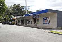
Located on Tui Crescent are a small block of shops. A convenience store, Chinese takeaway, hairdresser and pharmacy.
Notes
- ↑ Roger Smith, GeographX (2005). The Geographic Atlas of New Zealand. Robbie Burton. pp. map 24. ISBN 1-877333-20-4.
- ↑ Quickstats about Maunu, New Zealand
- ↑ "Te Kete Ipurangi - Pompallier Catholic College". Ministry of Education.
- ↑ "Pompallier - History & Special Character". Pompallier Catholic College. Retrieved 2008-04-19.
- ↑ "Te Kete Ipurangi - Maunu School". Ministry of Education.
- ↑ "Greetings - Nga mihi nui ki a koe!". Maunu School. Retrieved 2008-04-19.
- ↑ "Te Kete Ipurangi - Northland Health Camp School". Ministry of Education.
- ↑ "Education Review Report: Northland Health Camp School". New Zealand Education Review Office. May 2006.
External links
Coordinates: 35°44′36″S 174°16′38″E / 35.743195°S 174.277323°E