Medlicott Dome
| Medlicott Dome | |
|---|---|
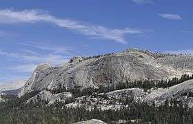 Medlicott Dome seen from Pywiack Dome. | |
| Highest point | |
| Elevation | 9,665[1] ft (2,946 m) NAVD 88 |
| Prominence | 1,086 ft (331 m) [2] |
| Coordinates | 37°51′23″N 119°25′34″W / 37.85639°N 119.42611°WCoordinates: 37°51′23″N 119°25′34″W / 37.85639°N 119.42611°W [1][3] |
| Geography | |
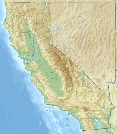 Medlicott Dome  Medlicott Dome Location of Medlicott Dome in California | |
| Location | Yosemite National Park, Tuolumne County, California, U.S. |
| Parent range | Sierra Nevada |
| Topo map | USGS Tenaya Lake |
| Climbing | |
| Easiest route | class 3 scrambling |
Medlicott Dome is a prominent granite dome in Yosemite high country. It is located on the southeast side of Tioga Road, between Mariolumne Dome and Dozier Dome, not too far from Pywiack Dome, Cathedral lakes and Fairview Dome. Popular with climbers, hikers and backpackers due to short approach, easy scrambling and great views.[3]
Climbing
.jpg)
Medlicott Dome has a large number of climbing routes, most of which are bolted faces with occasional cracks and offwidths. Among them are such classics as:[3][4]
- Shagadellic (class 5.8)
- Ceibola (class 5.10b)
- Goldmember (class 5.9)
- Super Chicken (class 5.9)
- Piss Easy (class 5.8 R)
- Bachar-Yerian (class 5.11c R/X) climbed in 1981 by John Bachar and Dave Yerian.[5]
- Peace (class 5.13c/d), first climbed in 1995 by Ron Kauk and Chris Falkenstein[6] and featured in the movie Masters of Stone IV.[3]
Etymology
The dome was named after Henry P. Medlicott who in 1882, with H. B. Carpenter surveyed Great Sierra Wagon Road aka. Tioga Road through Yosemite.[7] Henry P. Medlicott was a judge and US Deputy Mineral Surveyor from Lundy, California. Original name of the peak recorded in 1870 was Court House Rock. In 1882 a mining publication referred to it as Mount Medlicott. Present name was first recorded in 1883 and the name first appeared on a quadrangle map in 1956.[8]
References
- 1 2 "Medlicott Dome". Geographic Names Information System. United States Geological Survey. Retrieved 2016-01-31.
- ↑ "Medlicott Dome, California". Peakbagger.com. Retrieved 2016-01-31.
- 1 2 3 4 "Medlicott Dome". SummitPost.org. Retrieved 2016-01-31.
- ↑ "Medlicott Dome Rock Climbing". Mountain Project. Retrieved 31 January 2016.
- ↑ Reid, Don; Chris Falkenstein (1992). Rock Climbs of Tuolumne Meadows, Third Edition. Evergreen, Colorado, USA: Chockstone Press. p. 129. ISBN 0-934641-47-1.
- ↑ Barnes, Greg; McNamara, Chris; Roper, Steve (2009). Tuolumne Free Climbs (2nd ed.). SuperTopo. ISBN 0976523574. Retrieved 31 January 2016.
- ↑ Historic American Engineering Record (1991).
 Tioga Road (HAER No. CA-149) written historical and descriptive data. Wikisource.
 - ↑ Browning, Peter (2005). Yosemite Place Names: The Historic Background of Geographic Names in Yosemite National Park. Lafayette, CA: Great West Books. p. 95. ISBN 0-944220-19-3.