Metolius River
| Metolius River | |
|---|---|
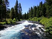 Wizards Falls on the Metolius River, where the river drops over a ledge | |
|
Map of the river course | |
| Basin | |
| Main source |
Metolius Springs 3,000 ft (910 m) 44°25′39″N 121°38′07″W / 44.427617°N 121.635330°W[1] |
| River mouth |
Lake Billy Chinook 1,945 ft (593 m) 44°35′51″N 121°17′13″W / 44.597619°N 121.286991°WCoordinates: 44°35′51″N 121°17′13″W / 44.597619°N 121.286991°W |
| Basin size | 315 sq mi (820 km2) |
| Physical characteristics | |
| Length | 29 mi (47 km) |
| Discharge |
|

The Metolius River (pronounced muh TOLL ee us) is a tributary of the Deschutes River (through Lake Billy Chinook) in Central Oregon, United States, near the city of Sisters. The river flows north from springs near Black Butte, then turns sharply east, descending through a series of gorges before ending in the western end of the lake. The unincorporated community of Camp Sherman lies astride the southern end of the river.
The river's drainage basin is 315 square miles (820 km2) in area and, according to at least one estimate, contains 110 miles (180 km) of perennial streams, 324 miles (521 km) of intermittent streams, 42 lakes, and 121 ponds.[3]
Headwaters

The headwaters of the river are at Metolius Springs, where the river emerges from two clusters of springs at the base of Black Butte. Water flows to these springs from the drainage basin around Black Butte Ranch, several miles to the south. The elevation of the drainage basin is 300 feet (91 m) above that of the springs, forming a natural standpipe that tends to stabilize the river's rate of flow.[4]
As a consequence, the water level in the Metolius River is relatively constant. The rate of flow at the headwaters is approximately 190 cubic metres per minute (6,700 cu ft/min) or 50,000 gallons per minute), although it grows by an additional 2,300 cubic metres per minute (81,000 cu ft/min) or 600,000 gallons per minute) by the time the river reaches Lake Billy Chinook. Similarly, the water temperature is also stable; at the river source, the water temperature is a consistent 48 °F (8.9 °C).[5]
General
The Metolius River flows 28.6 miles (46.0 km) from Metolius Springs through the Deschutes National Forest, emptying into Lake Billy Chinook and ultimately the Deschutes River. The upper 11.5 miles (18.5 km) of the river are popular for catch-and-release fishing, whitewater rafting, picnicking, and camping. The lower 17 miles (27 km) are on the boundary of the Warm Springs Indian Reservation, and flow by "a primitive area where motorized vehicles are not allowed."
The Metolius River was officially designated a National Wild and Scenic River in 1988.[6][7]
Many of the summer homes along the Metolius River are constructed on United States Forest Service land, under provisions of a 1915 act of Congress, and are generally required to be set back from the river at least 50 feet (15 m), allowing public access to the river.
Wildlife
The Metolius River supports a broad cross-section of the wildlife present in the Central Oregon region. The river itself is home to several fish species, including rainbow trout, bull trout, kokanee salmon and mountain whitefish. Larger animals including river otters and beaver inhabit the areas in and immediately around the river, and larger land mammals, including mule deer, elk, black bear, and cougar range in the surrounding area.[8] Migratory waterbirds such as the mallard and the Canada goose are common in the spring and summer, as are raptors such as the osprey and the red-tailed hawk. The white-headed woodpecker, generally rare and of interest to many birders, is quite common in several areas along the river.[9]
Recreation
Sport fishing for rainbow trout and bull trout is fly-fishing only on the upper Metolius—and catch-and-release, with barbless hooks. A number of small resorts and shops cater to fishermen and other visitors, principally in the community of Camp Sherman.[6][10]
Hiking and horseback riding are popular activities in the area, particularly on the upper, southern portion of the river, with trails extending up and down the river and into the forests on both sides. There are also a number of developed campgrounds on the banks of the river. Fishing, rafting, hunting and cross-country skiing are all popular seasonal activities.
The Wizard Falls Fish Hatchery is about 10.6 miles (17.1 km) north of the headwaters. This hatchery raises rainbow trout, kokanee, and salmon. The hatchery is open to visitors, with various species of trout and other fish on display in ponds.[11]
Coordinates
Coordinates from GNIS list one point per 7.5 minute map. The source and mouth are not repeated here.
| seq num | location | usgs map |
|---|---|---|
| 2 | 44°35′30″N 121°22′34″W / 44.591784°N 121.376161°W | Fly Creek |
| 3 | 44°37′29″N 121°28′49″W / 44.624839°N 121.480332°W | Metolius Bench |
| 4 | 44°38′07″N 121°30′04″W / 44.635394°N 121.501166°W | Shitike Butte |
| 5 | 44°37′27″N 121°36′00″W / 44.624283°N 121.600058°W | Prairie Farm Spring |
| 6 | 44°32′24″N 121°37′36″W / 44.540117°N 121.626723°W | Candle Creek |
See also
- List of Oregon rivers
- List of National Wild and Scenic Rivers
- The National Forest Foundation's Conservation Plan for the Metolius River
References
- ↑ U.S. Geological Survey Geographic Names Information System: Metolius River
- ↑ Palmer, Tim (2014). Field Guide to Oregon Rivers. Corvallis: Oregon State University Press. pp. 220–22. ISBN 978-0-87071-627-0.
- ↑ Deschutes Subbasin Plan, Northwest Power and Conservation Council
- ↑ "The Ore Bin, Volume 34, No. 3, March 1972, p. 51" (PDF). Retrieved 2008-04-21.
- ↑ "The Ore Bin, Volume 34, No. 3, March 1972, p. 43" (PDF). Retrieved 2008-04-21.
- 1 2 "Metolius River, Oregon", Public Land Information Center, Public Lands Interpretive Association, Albuquerque, New Mexico, 2008.
- ↑ “Metolius, Oregon”, Wild and Scenic Rivers Act, Public Law 90-542 (as amended), 16 United State Code 1271-1287, 8 August 2002.
- ↑ ODFW Mammals of Oregon
- ↑ Birds of the Metolius Basin, Metolius River Association
- ↑ "Camp Sherman", Metolius Recreation Association, Online Highway.com, Camp Sherman, Oregon, 24 August 2008.
- ↑ Wizard Falls Hatchery, Oregon Department of Fish and Wildlife
External links
 Media related to Metolius River at Wikimedia Commons
- Upper Deschutes Watershed Council