Mexican Federal Highway 5
| ||||
|---|---|---|---|---|
| Carretera Federal 5 | ||||
| Route information | ||||
| Maintained by Secretariat of Communications and Transportation | ||||
| Length: | 200 km (124 mi) | |||
| Major junctions | ||||
| North end: |
| |||
|
| ||||
| South end: | San Felipe | |||
| Highway system | ||||
|
Mexican Federal Highways
| ||||

Mexican Federal Highway (carretera federal) 5 follows the northeast length of the state of Baja California from the US-Mexico border in Mexicali at the northern end to San Felipe in the south.[1][2] The highway is entirely inside the municipality of Mexicali. However, a state highway from San Felipe to Puertecitos (municipality of Ensenada) is usually considered part of the federal highway. From San Felipe to the south, the road follows the seacoast of the Gulf of California.
Route description
The road begins in the border city of Mexicali at the western border crossing. It has four lanes from there to about km 80.[3] At this point it becomes a two-lane highway (with little or no shoulder in most areas) until km 160, about 18 km (11 mi) south of the junction with Mexican Federal Highway 3, and about 40 km (24 mi) north of San Felipe. From there, the highway is a broad, divided, four-lane highway with a median and ample shoulders, until it ends in San Felipe.
The new highway segments being constructed from San Felipe to the north and Mexicali to the south are raised, with drainage culverts passing underneath the highway. These have replaced the dips, or fords (vados) that formerly provided drainage across the highway. The resulting highway is a much higher quality road.
The interchange with Highway 3 has been completed, so that no turns across traffic are required.
Earthquake damage and repairs
The epicentre (32°15'32"N, 115°17'13.2"W) of the magnitude 7.2 earthquake on April 4th, 2010 (2010 Baja California earthquake) is about 3 km east of the highway.[4] Repairs on the highway began nearly immediately. From km 20 to km 38, SCT (Secretaría de Comunicaciones y Transportes) contractors re-levelled the road and filled cracks.
The road to Puertecitos
The state route that starts in San Felipe and continues to Puertecitos is a natural extension of the federal highway. It is an undivided, two-lane highway that has some rough spots and has many significant dips or fords where the highway meets normally-dry steams. One of the largest is labelled on the road in both directions as the "OH SHIT DIP."
-
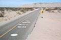
Road markings just south of the dip with the vado to the north beyond on Mexican Highway 5.
-
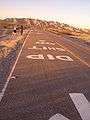
The markings on the other side of the road with just the mountains to the north in the background
Baja California
- Mexicali intersection with Mexican Federal Highway 2
- El Chinero intersection with Mexican Federal Highway 3 north of San Felipe
- Puertecitos The continuation of Baja 5 to Gonzaga Bay is now paved. The survey crews are currently working on the final section of Baja 5 to the Highway 1/highway 5 junction at Chapala. This project is intended to be complete by 2015.
References
- ↑ "Atlas por Entidad Federativa". Secretaría de Comunicaciones y Transportes de México. Retrieved August 28, 2009.
- ↑ "Baja California" (PDF). Secretaría de Comunicaciones y Transportes de México. Retrieved December 2, 2011.
- ↑ "Mexicali to San Felipe via Highway 5". sanfelipe.com.mx. Retrieved November 28, 2011.
- ↑ "Magnitude 7.2 - BAJA CALIFORNIA, MEXICO". United States Geological Survey. Retrieved April 10, 2010.
| Highways |
|
|---|---|
| Toll roads | |