Mid Atlantic Water Resource Region
The Mid Atlantic Water Resource Region is one of 21 major geographic areas, or regions, in the first level of classification used by the United States Geological Survey to divide and sub-divide the United States into successively smaller hydrologic units. These geographic areas contain either the drainage area of a major river, or the combined drainage areas of a series of rivers.[1][2]
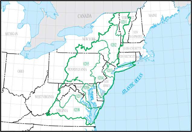
The Mid Atlantic region, which is listed with a 2-digit HUC code of 02, has an approximate size of 106,634 square miles, and consists of 8 sub-regions, which are listed with the 4-digit HUC codes of 0201 through 0208.
This region includes the drainage within the United States that ultimately discharges into: (a) the Atlantic Ocean within and between the states of New York and Virginia; (b) Long Island Sound south of the New York-Connecticut State Line; and (c) the Riviere Richelieu, a tributary of the St. Lawrence River. Includes all of Delaware and New Jersey and the District of Columbia, and parts of Connecticut, Maryland, Massachusetts, New York, Pennsylvania, Vermont, Virginia, and West Virginia.[3]
Listing of Water Resource Sub-Regions
| Sub-Region HUC[4] | Sub-Region Name[4] | Sub-Region Description[3] | Sub-Region Location[4] | Sub-Region Size (mi2)[4] | Sub-Region Map |
|---|---|---|---|---|---|
| 0201 | Richelieu | The Riviere Richelieu Basin, including Lake Champlain drainage, within the United States. | Located in New York and Vermont. | 7,720 |  |
| 0202 | Upper Hudson | The Hudson River Basin to and including the Popolopen Brook Basin just upstream from Bear Mountain Bridge. | Located in New Jersey, New York, Massachusetts, and Vermont. | 12,666 |  |
| 0203 | Lower Hudson-Long Island | The coastal drainage and associated waters from the Byram River Basin boundary, to the Manasquan River Basin boundary, including the Hudson River Basin downstream from the Popolopen Brook Basin boundary, Long Island and Block Island Sounds south of the New York-Connecticut state line, and Long Island. | Located in Connecticut, New Jersey, and New York. | 7,259 |  |
| 0204 | Delaware-Mid Atlantic Coastal | The coastal drainage and associated waters from and including the Manasquan River Basin to and including the Delaware River Basin which includes Delaware Bay. | Located in Delaware, Maryland, New Jersey, New York, and Pennsylvania. | 17,977 |  |
| 0205 | Susquehanna | The Susquehanna River Basin. | Located in Maryland, New York, and Pennsylvania. | 27,500 |  |
| 0206 | Upper Chesapeake | The Chesapeake Bay and its tributary drainage north of the Maryland-Virginia state line including the Pocomoke River drainage, excluding the Susquehanna and Potomac River Basins; and the Coastal drainage from the Delaware Bay drainage boundary to Chincoteague Inlet on the Delmarva Peninsula. | Located in Delaware, Maryland, Virginia, and Pennsylvania. | 5,871 |  |
| 0207 | Potomac | The Potomac River Basin. | Located in District of Columbia, Maryland, Pennsylvania, Virginia, and West Virginia. | 14,679 |  |
| 0208 | Lower Chesapeake | The Chesapeake Bay and its tributary drainage south of the Maryland-Virginia state line excluding the Pocomoke River drainage; and the Coastal drainage from Chincoteague Inlet on the Delmarva Peninsula to the Back Bay drainage boundary. | Located in Virginia. | 20,682 |  |
See also
References
- ↑ "Science in Your Watershed - Locate Your Watershed". USGS. Retrieved 2016-10-12.
- ↑ "Hydrologic Unit Maps". USGS. Retrieved 2016-10-13.
- 1 2 "Boundary Descriptions and Names of Regions, Subregions, Accounting Units and Cataloging Units". USGS. Retrieved 2016-10-13.
- 1 2 3 4 McManamay RA, Bevelhimer MS, Kao SC, Yaxing W, Martinez-Gonzalez M, Samu N (2013). "National Hydropower Asset Assessment Environmental Attribution". USGS-Oak Ridge National Laboratory. Retrieved 2016-10-13.