Mid State Trail (Pennsylvania)
| Pennsylvania Mid State Trail | |
|---|---|
|
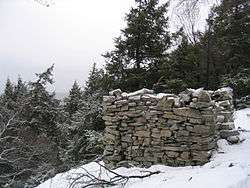
The "Roman Tower", on the trail near Boalsburg, Pennsylvania | |
| Length | 522.98 km (325 mi) |
| Location | Pennsylvania and Maryland, United States |
| Trailheads |
North: New York State border near Lawrenceville, Pennsylvania South: Black Valley Rd near Green Ridge State Forest in Flintstone, Maryland (at the Mason–Dixon line) |
| Use | Hiking |
| Elevation | |
| Highest point | Martin Hill, in Bedford County, Pennsylvania, 829 m |
| Lowest point | Near site of Fort Horn, Wayne Township, Clinton County, Pennsylvania beside West Branch Susquehanna River |
| Hiking details | |
| Trail difficulty | Moderate to Strenuous |
| Season | Spring to fall |
| Sights | Pastoral views and cultural remnants |
| Hazards |
Severe weather Poison ivy American black bear Timber rattler |
The Mid State Trail (MST) is a 522.98 km-long (324.96 mi) main trail network with many side trails located in the Ridge-and-Valley Appalachians and Allegheny Plateau of Central Pennsylvania. It is known as "The Wildest Trail in Pennsylvania". In 2006, the MST was announced as part of the Great Eastern Trail network of footpaths intended to extend from Alabama to New York State.
The northern terminus of the trail is at the New York State border near Lawrenceville, Pennsylvania, meeting Crystal Hills Trail, a branch of Finger Lakes Trail crossing eastern Steuben County, New York. The southern end is on Black Valley Road at the Pennsylvania-Maryland border near Flintstone, Maryland, meeting the route of Great Eastern Trail through Green Ridge State Forest. As of 2015 there remains a 1.79 km (1.11 mi) unmarked gap southeast of Wellsboro, Pennsylvania.[1] The MST is primarily on public land – state forests, game lands, and parks. MST uses private lands by permission on occasion, generally closer to the Maryland and New York borders.
The Mid State Trail has many views offered by its placement on narrow ridges. The MST provides an illusion of remoteness and solitude yet is rarely more than two kilometers from the nearest road. The MST was the first trail in the US to use metric measure and is still one of the few to do so. The current Mid State Trail guide states: "The MST was the first hiking trail in the United States to use metric measure. The second edition of the guide (1973) was completely metric. Metrication is a patriotic measure designed to help end our cultural isolation and ease our chronic balance of payments problems."[2]
Marking
Rectangular orange blazes mark the main trail. Yellow and blue blazes are used to mark other trails. The Mid State Trails mark the trail with single rectangles and two rectangles to denote turns. The orange blazes on most parts of the Mid State Trail are more numerous and recent (brighter color) than the blue blazes on other adjacent trails.
Trailheads
The Mid State Trail guide, published by the Mid State Trail Association, is an excellent source for the trailheads along the trail. Access points occur regularly, but not often enough to disrupt your hiking experience. The Purple Lizard Map illustrates portions of the Mid State and Standing Stone Trail on their Rothrock State Forest map.
Hazards
Black bears, bobcats, and rattlesnakes can present a danger. When bears and people cross paths in the wild, usually the bear just wishes to leave the area. Very rarely will a bear act hostile towards people. Bobcats are only dangerous if cornered, startled or threatened.
The common rattlesnake of Pennsylvania, the timber rattler (Crotalus horridus horridus), has venom of a medium potency. The venom can cause painful injuries but is rarely lethal. Many times when timber rattlers strike for protection, they will not inject venom. Administering proper first aid, keeping calm and quickly receiving medical attention is the best response to a bite.
See also
- Tiadaghton State Forest
- Tioga State Forest
- Rothrock State Forest
- Bald Eagle State Forest
- Buchanan State Forest
- Pennsylvania State Game Lands
- Similarly named Midstate Trail in Massachusetts
- Great Eastern Trail
References
- Thomas Thwaites, Scott Adams, Peter Fleszar, and Kevin Busko, Guide to Pennsylvania Mid State Trail, 12th edition. Mid State Trail Association, 2012, ISBN 978-1-931496-11-7
- Jeff Mitchell, Backpacking Pennsylvania: 37 Great Hikes, Stackpole Books, 2004, ISBN 0-8117-3180-4
External links
- Official website
- A History of the Mid State Trail
- Photos of section of the Mid State Trail
- Honoring the Life of Tom Thwaites
- PA DCNR's Mid State Trail Page (covers only areas on their lands)
- Purple Lizard Maps includes detailed Mid State Trail linework on their Rothrock map
- Listing of hikes in all four regions of the Mid State Trail
Coordinates: 39°47′36″N 78°32′48″W / 39.79337°N 78.54675°W