Mijares (river)
| Mijares / Millars | |
|---|---|
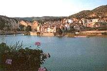 The Mijares River at the Sitjar dam with Ribesalbes town in the background | |
| Country | Spain |
| Basin | |
| Main source |
Sierra de Gúdar, El Castellar 1,600 m (5,200 ft) |
| River mouth |
Mediterranean Sea 0 m (0 ft) |
| Basin size | 4,028 km2 (1,555 sq mi) |
| Physical characteristics | |
| Length | 156 km (97 mi) |
| Discharge |
|
The Mijares or Millars (Spanish: Mijares, Catalan: Millars, Aragonese: Millars) is a river in Aragon and the Valencian Community, eastern Spain. It flows into the Mediterranean Sea between Almassora and Burriana. The Mijares River marks the southernmost limit of the Catalan Mediterranean System.
This river originates at a height of 1,600 m in the Sierra de Gúdar, Sistema Ibérico. It is 156 km long, with a 4,028 km2 wide basin and an average flow of 14.72 m3 per second at Cirat. This river is the main source of irrigation water for agriculture in the Plana Baixa comarca.[1]
See also
References
- ↑ Joaquim Aparici Vilar, L'Agricultura al terme de Borriana, Universitat Jaume I, Castelló de la Plana. ISBN 84-8021-030-3
External links
| Wikimedia Commons has media related to Mijares River. |
Coordinates: 39°54′31.02″N 0°0′44.18″E / 39.9086167°N 0.0122722°E
This article is issued from Wikipedia - version of the 12/1/2016. The text is available under the Creative Commons Attribution/Share Alike but additional terms may apply for the media files.