Mirna Peč
| Mirna Peč | |
|---|---|
 | |
 Mirna Peč Location in Slovenia | |
| Coordinates: 45°51′28.71″N 15°5′15.21″E / 45.8579750°N 15.0875583°ECoordinates: 45°51′28.71″N 15°5′15.21″E / 45.8579750°N 15.0875583°E | |
| Country |
|
| Traditional region | Lower Carniola |
| Statistical region | Southeast Slovenia |
| Municipality | Mirna Peč |
| Area | |
| • Total | 6.5 km2 (2.5 sq mi) |
| Elevation | 233 m (764 ft) |
| Population (2013) | |
| • Total | 1,015[1] |
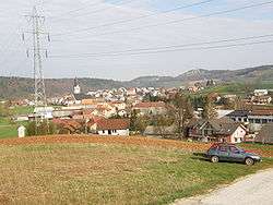
Mirna Peč (pronounced [ˈmiːɾna ˈpeːtʃ]; German: Hönigstein[2]) is a rural settlement in southeast Slovenia. It is the seat of the Municipality of Mirna Peč.
Geography
Mirna Peč is located about 10 km northwest of Novo Mesto, the cultural and administrative centre of the traditional region of Lower Carniola, in the heart of the Temenica Valley. Mirna Peč consists of 16 streets: Brezence, Borovje, Češence, Industrijska cesta, Ivanja Vas, Marof, Na hirb, Ob avtocesti, Postja, Prisojna Pot, Rogovila, Rožna Ulica, Šranga, Trg, and Vihre.[3]
Culture
The Mirna Peč parish church of Saint Cantianius is part of the Roman Catholic Diocese of Novo Mesto. It was built in 1915 on the site of a 15th-century predecessor.[4]
Notable people
Notable people that were born or lived in Mirna Peč include:
- Anton Bartel (1853–1938), lexicographer[5]
- Franc Dular (1860–1924), veterinarian
- Karel Javoršek (1873–1916), composer[5]
- Ivan Kovačič (a.k.a. Efenka) (1921–1963), Partisan and People's Hero of Yugoslavia[5]
- Stane Potočar (a.k.a. Lakar) (1919–1997), Partisan and People's Hero of Yugoslavia[5]
- Mara Rupena (a.k.a. Osolnik) (1918–2003), Partisan and editor[5]
- Zora Rupena (a.k.a. Katja) (1920–1945), Partisan[5]
- Ludvik Starič (1906–1989), motorcyclist
- Albert Struna (1901–1982), engineer[5]
References
- ↑ "Statistical Office of the Republic of Slovenia".
- ↑ Leksikon občin kraljestev in dežel zastopanih v državnem zboru, vol. 6: Kranjsko. 1906. Vienna: C. Kr. Dvorna in Državna Tiskarna, p. 154.
- ↑ "Odlok o naseljih in ulicah v Občini Mirna Peč" (PDF). Uradni list Republike Slovenije (in Slovenian) (35 ed.). Ljubljana: Služba Vlade RS za zakonodajo. 26 April 2013. p. 4284. ISSN 1318-0576. Retrieved 26 February 2014. Check date values in:
|year=, |year= / |date= mismatch(help) - ↑ "EŠD 2041". Registry of Immovable Cultural Heritage (in Slovenian). Ministry of Culture of the Republic of Slovenia. Retrieved 20 April 2011.
- 1 2 3 4 5 6 7 Savnik, Roman, ed. 1971. Krajevni leksikon Slovenije, vol. 2. Ljubljana: Državna založba Slovenije, p. 513.
External links
- Mirna Peč at Geopedia
-
 Media related to Mirna Peč at Wikimedia Commons
| Settlements | Administrative centre: Mirna Peč
|  | ||||||
|---|---|---|---|---|---|---|---|---|
| Landmarks |
| |||||||
| Notable people |
| |||||||