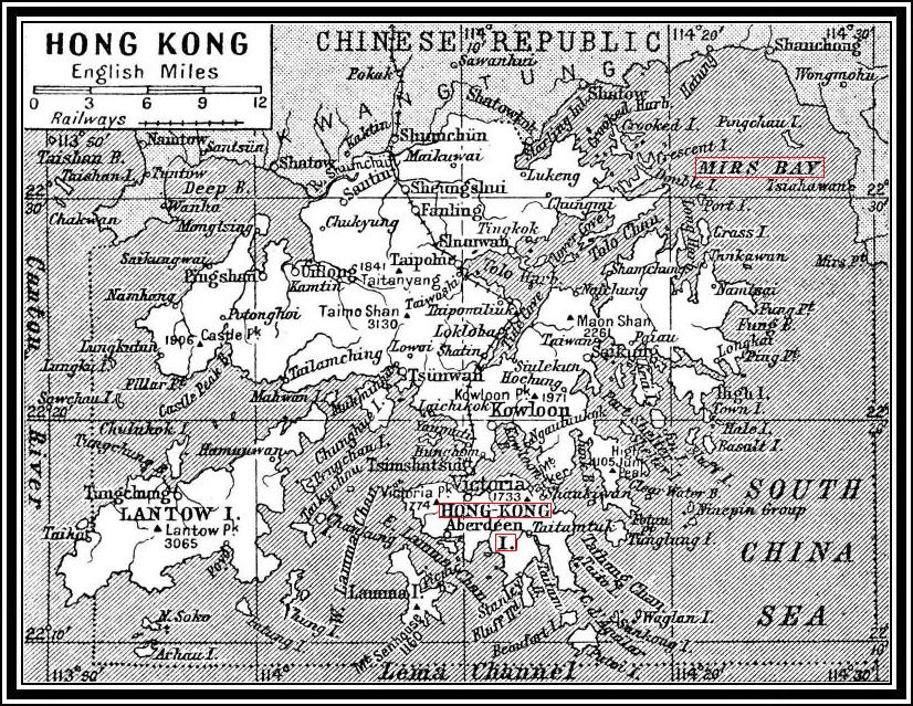
Mirs Bay
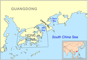
Mirs Bay (also known as Tai Pang Wan, Dapeng Wan, Dapeng Bay) (Chinese: 大鵬灣) is a bay in the northeast of Kat O and Sai Kung Peninsula of Hong Kong, China.[1] The north and east shores are surrounded by Yantian and Dapeng New District of Shenzhen. Ping Chau stands in the midst of the bay.
History
Mirs Bay along with other waterways near Hong Kong once was home to various coastal defence forts (e.g. Dapeng Fortress) used against pirates during the Ming Dynasty.[2]
Mirs Bay was used by then American Commodore (later Admiral) George Washington Dewey during the Spanish American War as refuge and repair facility for the US Navy.[3]
Features
Within the bay are smaller harbours or inlets on the Hong Kong side:
- Starling Inlet
- Tolo Harbour
- Crooked Harbour
- Long Harbour
- Sai Tin Hoi
- Hoi Ha Bay[4][5]
The bay includes a number of islands, with an extensive group lying in the northwestern part of the bay, including:[6]
- Double Island
- Crescent Island
- Crooked Island
- Grass Island, at the western side of the entrance to Mirs Bay
- Round Island
To the south of Mirs Bay water flows out to the South China Sea.
References
- ↑ "Mirs Bay, Hong Kong, Admiralty Standard Nautical Chart 4128" (Map). Paper Chart Folio No. 50. 1:30,000. United Kingdom Hydrographic Office (UKHO). 25 October 2012.
- ↑ "Gallery 2: The Ming Period (1368-1644)". Hong Kong Museum of Coastal Defence. Archived from the original on 5 September 2013.
- ↑ Watterson, Henry (1898). "The Spanish American war: American blockade of the Philippines". In Bancroft, Hubert H. The Great Republic by the Master Historians, Volume IV. Archived from the original on 16 March 2012.
- ↑ Lam, Katherine K. Y. (1999). "Hydrography, nutrients and phytoplankton, with special reference to an hypoxic event, at an experimental artificial reef at Hoi Ha Wan, Hong Kong". In Morton, Brian. Asian Marine Biology 16. Hong Kong: Hong Kong University Press. pp. 35–64, page 36. ISBN 978-962-209-520-5.
- ↑ Au Yiu-Keung (Au, Aaron); et al. (2003). "Hoi Ha Wan – the Marine Kaleidoscope of Hong Kong" (PDF). Year 2003 Conference on "Sustainable Tourism". Archived from the original on 1 September 2014.
- ↑ Findlay, Alexander G. (1878). A directory for the navigation of the Indian Archipelago, China, and Japan (second ed.). London: R. H. Laurie. pp. 995–998. OCLC 8674578.
External links
- "Map: Hong Kong". Naval-History.Net. c. 1919. showing Mirs Bay and major islands
- "Photo: Hoi Ha Bay". Save Hoi Ha Community. April 2014. Archived from the original on 1 September 2014.
Coordinates: 22°34′N 114°22′E / 22.567°N 114.367°E