Missisquoi Bay
| Missisquoi Bay | |
|---|---|
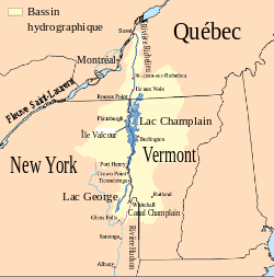 Map of Champlain Lake with Missisquoi Bay in North-East area of the lake. | |
| Location | Venise-en-Québec |
| Coordinates | Coordinates: Haut-Richelieu_type:waterbody 45°01′12″N 73°08′42″W / 45.02000°N 73.14500°W |
| Type | Bay |
| Part of | Champlain Lake |
| Primary inflows | Rivière aux Brochets (baie Missisquoi) Pikes River (Missisquoi Bay) |
| Primary outflows | Champlain Lake and Richelieu River |
| Basin countries |
|
| Max. length | 5 km (3.1 mi) |
| Max. depth | 4.75 m (15.6 ft) |
Missisquoi Bay is a large extension in the northern part of Champlain Lake, at the East of the output of the latter in Richelieu River. It takes the form of a violin head, handle leaving the head of the lake and having about 5 km in diameter. The bay is divided between the Quebec in Canada and Vermont in United States. The main town on its banks is Venise-en-Québec, a major summer resort. The river of the same name flows into the bay and the Missisquoi National Wildlife Refuge is located on the American side.
Toponymy
_1739.JPG)
Champlain, first governor of New France, was the first European to visit the region. The name that has an Abenaki origin, would mean "a lot of waterfowl" but other senses are also advanced. It appears officially in the eighteenth century in the concession document made on April 6, 1733 to Paul-Louis de Lusignan Dazemard as the "Missiskouy Bay". The graph will change several times. In 1855, when changes to electoral counties of Lower Canada into electoral districts, the Legislature finally adopts the form Missisquoi to designate the county and the region.
Geology
This is an in-ground by glaciers Bay ago 18,000 years and then cast their monitoring dewatering of the Champlain Sea there are approximately 8,000 years. The maximum depth of the bay is about 4.75 m and its bottom is made of regional marine deposits. The bay waters draining south into the Champlain Lake and the Richelieu River. Until the late 2000s, the water of the bay was stagnant and the bay was dying. At the opening of the new bridge on the US side, on the old road embankment was partly demolished which brought a flow of fresh water from the Champlain.
Environment
The bay has a great diversity of fauna and flora, including many species of birds, hence the establishment of a national refuge on the US side. Its beaches are very popular with vacationers in summer and its waters are laced with various pleasure boats, from personal watercraft, boats, etc. In winter, anglers on the ice engage in this activity.
See also
Other articles
- Pike River (Missisquoi Bay), a stream (fr: Rivière aux Brochets (baie Missisquoi)
- Pike River North (Missisquoi Bay), a stream (fr: Rivière aux Brochets (baie Missisquoi)
- Richelieu River, a stream
- Lake Champlain, a body of water
- Rivière-aux-Brochets Ecological Reserve, a bay
External links
- (French)Le Wiki de la Baie Missisquoi
- (French)Conservation Baie Missisquoi
- Site officiel du refuge faunique national de la baie Missisquoi