Mithapukur Upazila
| Mithapukur মিঠাপুকুর | |
|---|---|
| Upazila | |
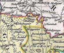
 Mithapukur Location in Bangladesh | |
| Coordinates: 25°32.5′N 89°17′E / 25.5417°N 89.283°ECoordinates: 25°32.5′N 89°17′E / 25.5417°N 89.283°E | |
| Country |
|
| Division | Rangpur Division |
| District | Rangpur District |
| Area | |
| • Total | 515.62 km2 (199.08 sq mi) |
| Population (2011) | |
| • Total | 5,08,133 |
| • Density | 990/km2 (2,600/sq mi) |
| Time zone | BST (UTC+6) |
| Website | Official Website of Mithapukur |
Mithapukur (/miːtɑːpuːkʊər/; মিঠাপুকুর Mithapukur [ˈmiʈʰaˌpukur]) is an upazila of Rangpur District[1] in the division of Rangpur, Bangladesh. The upazila is situated in the middle of Rangpur, surrounded by Rangpur Sadar to the north, Pirganj to the south, Badarganj and Phulbari to the west and Pirgachha and Sundarganj to the east. Mithapukur is famous for being the birthplace of Begum Rokeya Sakhawat Hossain and its sweet mango Harivanga.
Etymology
Mithapukur is the largest upazila in Rangpur zila in respect of both area and population.It came into existence in 1885 as a thana and was upgraded to upazila in 1983. Nothing is definitely known about the origin of the upazila name. It is said that Mir Jumla II, the Subahdar of Bengal, came there by the order of the Mughal Emperor Aurangzeb in order to invade Koch Bihar.[2] He set up a camp near the current Mithapukur Degree College during the period of his military expedition in Bengal. His forces faced an acute problem of water for which a pond was dug near the camp. The water of the pond was so sweet that Mir Jumla named the place "Mithapukur" (Mitha means Sweet and Pukur means Pond). Some believe that Shah Ismail Ghazi ordered to dig the pond. It is believed that the pond consisted of five separate ponds. But in course of time, they mixed into a single pond.
The name Mithapukur also appears in the James Rennell's Dury Wall Map of Bihar and Bengal, India (as Mettypukre) and N. Hindostan Map (as Mettypokra) and John Bartholomew's Map of Provinces of the Lower Ganges (as Mitapokhar).
Geography
Mithapukur is located at 25°32′30″N 89°17′00″E / 25.5417°N 89.2833°E. It has total area 515.62 km². Mithapukur possesses vast fertile land. The Jamunashwori, Akhira and Ghaghot are the major river flows through Mithapukur. The Akhira river, which divided to Mithapukur landscape into two parts. The land character of the western part of Mithapukur is red brown soil and eastern part is locally known as Poly area, which contains a large part of the Upazila. Gopalpur Forest is the main landmark of Terrace soils area.
Demographics
As of the 2011 Bangladesh census,[3] Mithapukur has a population of 5,08,133 where males constitute 2,52,325 and females constitute 2,55,807 of the population with annual population growth rate of 1.21%. The total number of household of Mithapukur is 1,35,073. Mithapukur has an average literacy rate of 46% (7+ years) compared to the national average of 51.8% literate and 2nd highest literacy rate among the upazila Rangpur district followed by Rangpur Sadar.[3] [3]
Mithapukur Upazila has a very diverse population with minority groups including Buddhists, Christians and tribes such as Santhal who have lived in the district from the beginning of settlement in this area.[4]
Economy
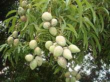
Agriculture is demographically the broadest economic sector and plays a significant role in the overall socio-economic fabric of Mithapukur. Mithapukur is the largest producer of mangoes, vegetables and potatoes in the district. Mithapukur is the birthplace of the sweet mango Harivanga, famous for its different taste.
Points of interest
Mithapukur Upazila has many historical and attractive places. Begum Rokeya Memorial in Pairaband is the birthplace of Begum Rokeya Sakhawat Hossain (1880–1932), an eminent educationist and a pioneer of women's liberation. Mithapukur's most popular tourist attractions are the Mithapukur Pond-Excavated during Mughal period, Benubon Buddhist Vihara-Mithapukur, The Mughal era three domed jami Masque- Mithapukur, Tanka jami Mosque at Latibpur and Gopalpur forest and Eco park.
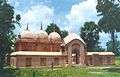 Mithapukur Mughal Era Masque
 Statue of Begum Rokeya near Begum Rokeya Memorial
Administration
Mithapukur has 17 Unions, 311 Mauzas and 315 villages. The 17 unions are as follows:
- Khoragach
- Ranipukur
- Payrabond
- Vangni
- Balarhat
- Kafrikhal
- Latibpur
- Changmari
- Moyenpur
- balua masempur
- Barobala
- Milonpur
- Gopalpur
- Durgapur
- Baro Hazrathpur
- Mirzapur
- Imadpur
Transport
Mithapukur is well connected to Dhaka, Rangpur, Bogra by National highway. Mithapukur can be reached by the 304 km long National highway(N5) from Dhaka. The highway also provides a link to the neighbouring divisional town Rangpur by 18 km from Upazila Sadar. Highway buses run from kallanpur, Dhaka to Rangpur and it takes about six to seven hours.
Notable residents
- Begum Rokeya Sakhawat Hossain
- H N Ashequr Rahman,Parlamment member, entrepreneur
- Dr. Rashid Askari, writer, columnist, professor of English and current vice chancellor of Kushtia Islamic University, Bangladesh.
- Dr. Mujibur Rahaman, Health Scientist who has had enormous publication on both preventive and curative medical interventions for diarrhoeal diseases.He had long standing association with icddr,b and made many publications in the area and of nutrition and health.
See also
References
- ↑ Abu Md. Iqbal Rumi Shah (2012). "Mithapukur Upazila". In Sirajul Islam and Ahmed A. Jamal. Banglapedia: National Encyclopedia of Bangladesh (Second ed.). Asiatic Society of Bangladesh.
- ↑ Col Ved Prakash (2006). "Ahom Rule: Last Two Centuries". Encyclopaedia of North-East India, Volume 1 (hardcover ed.). Atlantic Publishers & Distributors (P) Ltd. ISBN 978-8126907038.
- 1 2 3 "Population & Housing Census 2011: Community Report of Rangpur" (PDF). BBS.
- ↑ Abdus Sattar (2012). "Rangpur District". In Sirajul Islam and Ahmed A. Jamal. Banglapedia: National Encyclopedia of Bangladesh (Second ed.). Asiatic Society of Bangladesh.
| Upazila/Thana: | ||
|---|---|---|