Monbazillac
For the wine, see Monbazillac AOC.
| Monbazillac | ||
|---|---|---|
|
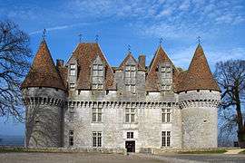
Château de Monbazillac | ||
| ||
 Monbazillac | ||
|
Location within Nouvelle-Aquitaine region  Monbazillac | ||
| Coordinates: 44°47′42″N 0°29′33″E / 44.795°N 0.4925°ECoordinates: 44°47′42″N 0°29′33″E / 44.795°N 0.4925°E | ||
| Country | France | |
| Region | Nouvelle-Aquitaine | |
| Department | Dordogne | |
| Arrondissement | Bergerac | |
| Canton | Sigoulès | |
| Intercommunality | Bergerac Pourpre | |
| Government | ||
| • Mayor (2008–2014) | Jean-Pierre Peyrebrune | |
| Area1 | 19.58 km2 (7.56 sq mi) | |
| Population (2008)2 | 958 | |
| • Density | 49/km2 (130/sq mi) | |
| Time zone | CET (UTC+1) | |
| • Summer (DST) | CEST (UTC+2) | |
| INSEE/Postal code | 24274 / 24240 | |
| Elevation |
46–188 m (151–617 ft) (avg. 160 m or 520 ft) | |
|
1 French Land Register data, which excludes lakes, ponds, glaciers > 1 km² (0.386 sq mi or 247 acres) and river estuaries. 2 Population without double counting: residents of multiple communes (e.g., students and military personnel) only counted once. | ||
.svg.png)
Monbazillac is a commune in the Dordogne department in Nouvelle-Aquitaine in southwestern France.
Population
| Historical population | ||
|---|---|---|
| Year | Pop. | ±% |
| 1800 | 1,112 | — |
| 1831 | 1,204 | +8.3% |
| 1866 | 1,105 | −8.2% |
| 1901 | 873 | −21.0% |
| 1931 | 905 | +3.7% |
| 1962 | 907 | +0.2% |
| 1968 | 846 | −6.7% |
| 1975 | 789 | −6.7% |
| 1982 | 831 | +5.3% |
| 1990 | 902 | +8.5% |
| 1999 | 899 | −0.3% |
| 2008 | 958 | +6.6% |
See also
References
| Wikimedia Commons has media related to Monbazillac. |
This article is issued from Wikipedia - version of the 11/9/2016. The text is available under the Creative Commons Attribution/Share Alike but additional terms may apply for the media files.