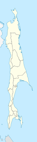
Moneron Island
Moneron Island, (Russian: Монерон, Japanese: 海馬島 Kaibato, Ainu: Todomoshiri) is a small island located off Sakhalin Island.
Description
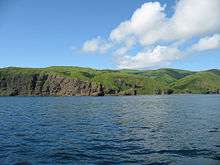
Moneron has an area of about 30 square kilometres (12 sq mi) and a highest point of 429 metres (1,407 ft). It is approximately 7.2 km (4.5 mi) long (N/S axis) by 5.5 km (3.4 mi) wide, and is located 41 nautical miles (76 km) from Sakhalin's port of Nevelsk and about 24 nautical miles (44 km) directly southwest of Sakhalin Island itself at the northeastern end of the Sea of Japan. It is the only landmass in the whole Tatar Straits. It has no permanent population.
History
The island was known as Todomoshiri ("island of sea lions") by its original Ainu inhabitants. It came under the daimyo of Matsumae clan in the 18th century and got its current European name from a visit of the French navigator La Perouse, who named it Moneron after Paul Mérault Monneron, the chief engineer of his expedition. Latterly, the Japanese named it Kaibatō (海馬島), which was a Sinicized rendition of its Ainu name, but it reverted to its European name after Japan's defeat in World War II and its occupation by the Soviet Union.
KAL 007
Korean Air Flight 007, with 269 passengers and crew, spiraled around Moneron Island twice during the final phase of its controlled 12-minute descent after being struck by a single air-to-air missile launched at it on September 1, 1983 from a Sukhoi Su-15, for straying into restricted Soviet airspace. Its precise position and final distance from the island are disputed.
Fauna and flora
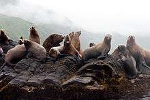
The island is a popular place for diving and for birds. Surrounded by steep cliffs and rocky islets, it is a haven for sea birds. The warm Tsushima Current brings abundant marine life to the surrounding waters and species normally found much further south abound.
In 2006, infrastructure was constructed to allow tourists to visit the island. The facilities are operated by the Moneron National Park, which is the first marine national park in Russia.

References
| Wikimedia Commons has media related to Moneron. |
Coordinates: 46°15′N 141°14′E / 46.250°N 141.233°E