Monmouth County, New Jersey
| Monmouth County, New Jersey | ||
|---|---|---|
|
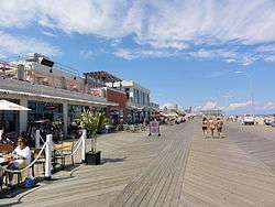
The boardwalk in Asbury Park | ||
| ||
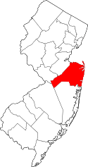 Location in the U.S. state of New Jersey | ||
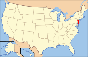 New Jersey's location in the U.S. | ||
| Founded | 1683 | |
| Named for | Rhode Island Monmouth Society or Monmouthshire | |
| Seat | Freehold Borough[1] | |
| Largest city |
Middletown Township (population) Howell Township (area) | |
| Area | ||
| • Total | 665.32 sq mi (1,723 km2) | |
| • Land | 468.79 sq mi (1,214 km2) | |
| • Water | 196.53 sq mi (509 km2), 29.54% | |
| Population | ||
| • (2010) |
630,380[2] 628,715 (2015 est.)[3] | |
| • Density | 1,341/sq mi (517.8/km²) | |
| Congressional districts | 4th, 6th | |
| Website |
www | |

Monmouth County /ˈmɒnməθ/ is a county located in Central New Jersey, in the United States within the New York metropolitan area and located in the central part of the state. It is the northernmost county along the Jersey Shore. Monmouth County had a Census-estimated population of 628,715 in 2015, representing a decrease of 0.3% from the 2010 Census, when the population was enumerated at 630,380,[3] in turn an increase of 15,079 from 615,301 at the 2000 Census, falling to the fifth-most populous county in the state, having been surpassed by Hudson County in 2010.[4][5] As of the 2014 Census Estimate, the county's population was 629,279.[6] Its county seat is Freehold Borough.[1][7] The most populous place was Middletown Township, with 66,522 residents at the time of the 2010 Census, while Howell Township covered 61.21 square miles (158.5 km2), the largest total area of any municipality.[5]
Monmouth County ranked 38th among the highest-income counties in the United States as of 2011, placing it among the top 1.2% of counties by wealth.[8] As of 2009, it was ranked 56th in the United States by personal per-capita income.[9]
History
An English navigator, Henry Hudson, and his crew aboard the Dutch vessel Half Moon, in 1609, spotted land in what is now Monmouth County,[10] most likely off Sandy Hook; however, some historical accounts credit this landing to present-day Keansburg. Among the first European settlers and majority landowners in the area was Richard and Penelope Stout. Penelope miraculously survived her wounds from a native attack in Sandy Hook and further lived to the age of 110. Additionally, a group of Quaker families from Long Island who settled the Monmouth Tract, an early land grant from Richard Nicolls issued in 1665. They were followed by a group of Scottish settlers who inhabited Freehold Township in about 1682–85, followed several years later by Dutch settlers. As they arrived in this area, they were greeted by Lenape Native Americans, who lived in scattered small family bands and developed a largely amicable relationship with the new arrivals.[11] Enslaved Africans were present in the area from at least 1680, and by 1726 made up 9% of the total population of the county.[12]
Monmouth County was established on March 7, 1683, while part of the province of East Jersey. On October 31, 1693, the county was partitioned into the townships of Freehold, Middletown and Shrewsbury.[13] Its name may come from the Rhode Island Monmouth Society[14] or from a suggestion from Colonel Lewis Morris that the county should be named after Monmouthshire in Wales, Great Britain. Other suggestions include that it was named for James Scott, 1st Duke of Monmouth (1649–1685), who had many allies among the East Jersey leadership.[15] In 1714, the first county government was established.
At the June 28, 1778, Battle of Monmouth, near Freehold Township, General George Washington's soldiers battled the British under Sir Henry Clinton, in the longest land battle of the American Revolutionary War. It was at Monmouth that the tactics and training from Friedrich Wilhelm von Steuben developed at Valley Forge during the winter encampment were first implemented on a large scale.[16]
At independence, Monmouth's population included 1,640 slaves, as well as an undetermined number of free African Americans. The number of enslaved persons fell steeply after 1820, though a small number remained until at least 1850. Monmouth's free African American population climbed from 353 in 1790 to 2,658 in 1860.[12]
Geography
According to the 2010 Census, the county had a total area of 665.32 square miles (1,723.2 km2), including 468.79 square miles (1,214.2 km2) of land (70.5%) and 196.53 square miles (509.0 km2) of water (29.5%).[5][17]
Much of Monmouth County remains flat and low-lying even far inland. However, there are some low hills in and around Holmdel Township, and one of them, Crawford Hill, the former site of a radar facility, is the county's highest point, variously listed at 380 to 391 feet (116 to 119 m) above sea level.[18][19] The top portion of the hill is owned by Alcatel-Lucent and houses a research laboratory of Bell Laboratories.[20] The northeastern portion of the county, in the Locust section of Middletown Township and the boroughs of Highlands and Atlantic Highlands, are also very hilly. The lowest point is sea level.
Along with adjacent Ocean County, Monmouth County is a mecca of boating and fishing. Its waterways include several rivers and bays that flow from the Raritan Bayshore into Raritan Bay and Lower New York Bay and into the Atlantic Ocean. The Manasquan Inlet is located in the county, which connects the Atlantic Ocean with the estuary of the Manasquan River, a bay-like body of saltwater that serves as the starting point of the Intracoastal Waterway, which attracts as many as 1,600 boats each weekend during the peak season.[21]
Adjacent counties
The county adjoins:[22]
- Middlesex County, New Jersey – northwest
- Ocean County, New Jersey – south
- Mercer County, New Jersey – west
- Burlington County, New Jersey – southwest
National protected area
Demographics
| Historical population | |||
|---|---|---|---|
| Census | Pop. | %± | |
| 1790 | 16,918 | — | |
| 1800 | 19,872 | 17.5% | |
| 1810 | 22,150 | 11.5% | |
| 1820 | 25,038 | 13.0% | |
| 1830 | 29,233 | 16.8% | |
| 1840 | 32,909 | 12.6% | |
| 1850 | 30,313 | * | −7.9% |
| 1860 | 39,346 | 29.8% | |
| 1870 | 46,195 | 17.4% | |
| 1880 | 55,538 | 20.2% | |
| 1890 | 69,128 | 24.5% | |
| 1900 | 82,057 | 18.7% | |
| 1910 | 94,734 | 15.4% | |
| 1920 | 104,925 | 10.8% | |
| 1930 | 147,209 | 40.3% | |
| 1940 | 161,238 | 9.5% | |
| 1950 | 225,327 | 39.7% | |
| 1960 | 334,401 | 48.4% | |
| 1970 | 461,849 | 38.1% | |
| 1980 | 503,173 | 8.9% | |
| 1990 | 553,124 | 9.9% | |
| 2000 | 615,301 | 11.2% | |
| 2010 | 630,380 | 2.5% | |
| Est. 2015 | 628,715 | [3][23] | −0.3% |
| Historical sources: 1790-1990[24] 1970-2010[5] 2000[25] 2010[2] 2000-2010[26] * = Lost territory in previous decade.[13] | |||
Census 2010
The 2010 United States Census counted 630,380 people, 233,983 households, and 163,320 families residing in the county. The population density was 1,344.7 per square mile (519.2/km2). The county contained 258,410 housing units at an average density of 551.2 per square mile (212.8/km2). The racial makeup of the county was 82.60% (520,716) White, 7.37% (46,443) Black or African American, 0.19% (1,211) Native American, 4.96% (31,258) Asian, 0.03% (211) Pacific Islander, 2.89% (18,187) from other races, and 1.96% (12,354) from two or more races. Hispanics or Latinos of any race were 9.67% (60,939) of the population.[2]
Out of a total of 233,983 households, 32.4% had children under the age of 18 living with them, 55.5% were married couples living together, 10.5% had a female householder with no husband present, and 30.2% were non-families. 25% of all households were made up of individuals, and 10.7% had someone living alone who was 65 years of age or older. The average household size was 2.66 and the average family size was 3.22.[2]
In the county, 23.8% of the population were under the age of 18, 7.8% from 18 to 24, 24% from 25 to 44, 30.6% from 45 to 64, and 13.8% who were 65 years of age or older. The median age was 41.3 years. For every 100 females the census counted 94.7 males, but for 100 females at least 18 years old, it was 91.9 males.[2]
Census 2000
As of the 2000 United States Census[27] there were 615,301 people, 224,236 households, and 160,328 families residing in the county. The population density was 1,304 people per square mile (503/km²). There were 240,884 housing units at an average density of 510 per square mile (197/km²). The racial makeup of the county was 84.39% White, 8.06% Black or African American, 0.14% Native American, 3.97% Asian, 0.02% Pacific Islander, 1.74% from other races, and 1.68% from two or more races. 6.20% of the population were Hispanic or Latino of any race.[25][28] Based on the first ancestries reported by Monmouth County residents in the 2000 Census, 23.2% of residents were of Italian ancestry, 23.0% Irish, 14.0% German, 7.5% Polish and 7.0% English ancestry.[28][29]
There were 224,236 households out of which 35.50% had children under the age of 18 living with them, 58.20% were married couples living together, 10.00% had a female householder with no husband present, and 28.50% were non-families. 23.80% of all households were made up of individuals and 9.60% had someone living alone who was 65 years of age or older. The average household size was 2.70 and the average family size was 3.24.[25]
In the county the population was spread out with 26.10% under the age of 18, 6.90% from 18 to 24, 30.40% from 25 to 44, 24.10% from 45 to 64, and 12.50% who were 65 years of age or older. The median age was 38 years. For every 100 females there were 94.40 males. For every 100 females age 18 and over, there were 90.90 males.[25]
The median income for a household in the county was $64,271, and the median income for a family was $76,823. Males had a median income of $55,030 versus $35,415 for females. The per capita income for the county was $31,149. About 4.5% of families and 6.3% of the population were below the poverty line, including 7.5% of those under age 18 and 7.0% of those age 65 or over.[28] [30]
Government
Monmouth County is governed by a five-member Board of Chosen Freeholders, who are elected at-large for three-year terms of office on a staggered basis, with either one or two seats up for election each year. Each January, the freeholders select one of their members to serve as the director of the board for the year to preside over the meetings and activities of the board. Monmouth County's Freeholders have both administrative and policy making powers. The freeholders oversee the five mandatory functions of county government delegated to it by the state. Each freeholder is assigned responsibility for one of the five functional areas: Administration and Special Services; Public Works and Engineering; Human Services, Health and Transportation; Finance and Administration of Justice, overseeing more than 70 county departments in total.[31] County Administrator Teri O'Connor, an appointed position, serves as the county's chief executive officer, and is responsible for carrying out the policies and directives established by the Board of Chosen Freeholders and managing the daily operations of the county's more than 3,000 employees.[32]
As of 2015, Monmouth County's Freeholders are:[31]
- Freeholder Director Gary J. Rich Sr. (R, Spring Lake, term as freeholder ends December 31, 2017; term as director ends 2015)[33]
- Freeholder Deputy Director Serena DiMaso (R, Holmdel Township, term as freeholder ends 2016; term as deputy director ends 2015)[34]
- Thomas A. Arnone (R, Neptune City, 2016)[35]
- Lillian G. Burry (R, Colts Neck Township, 2017)[36]
- John P. Curley (R, Middletown Township, 2015)[37]
Constitutional officers are County clerk Christine Giordano Hanlon (acting),[38] Sheriff Shaun Golden,[39] and Surrogate Rosemarie D. Peters.[40] Christopher J. Gramiccioni is the county's acting prosecutor, having been appointed by New Jersey Attorney General Jeffrey S. Chiesa as of July 1, 2012.[41]
Monmouth County constitutes Vicinage 9 of the New Jersey Superior Court.[42] Vicinage 9 is seated at the Monmouth County Courthouse in Freehold, with additional facilities in Freehold and Ocean Township; the Assignment Judge for Vicinage 9 is the Honorable Lisa P. Thornton.[43][44]
The 4th and 6th Congressional Districts cover the county.[45][46] New Jersey's Fourth Congressional District is represented by Christopher Smith (R).[47] New Jersey's Sixth Congressional District is represented by Frank Pallone (D, Long Branch).[48]
The county is part of the 11th, 12th, 13th and 30th Districts in the New Jersey Legislature.[49] For the 2016–2017 session (Senate, General Assembly), the 11th Legislative District of the New Jersey Legislature is represented in the State Senate by Jennifer Beck (R, Red Bank) and in the General Assembly by Joann Downey (D, Freehold Township) and Eric Houghtaling (D, Neptune Township).[50] For the 2016–2017 session (Senate, General Assembly), the 12th Legislative District of the New Jersey Legislature is represented in the State Senate by Samuel D. Thompson (R, Old Bridge Township) and in the General Assembly by Robert D. Clifton (R, Matawan) and Ronald S. Dancer (R, Plumsted Township).[51] For the 2016–2017 session (Senate, General Assembly), the 13th Legislative District of the New Jersey Legislature is represented in the State Senate by Joseph M. Kyrillos (R, Middletown Township) and in the General Assembly by Amy Handlin (R, Middletown Township) and Declan O'Scanlon (R, Little Silver).[52] For the 2016–2017 session (Senate, General Assembly), the 30th Legislative District of the New Jersey Legislature is represented in the State Senate by Robert Singer (R, Lakewood Township) and in the General Assembly by Sean T. Kean (R, Wall Township) and Dave Rible (R, Wall Township).[53]
Politics
| Year | Republican | Democratic |
|---|---|---|
| 2016 | 52.5% 165,305 | 43.1% 135,825 |
| 2012 | 51.8% 148,000 | 46.8% 133,820 |
| 2008 | 51.2% 160,433 | 47.5% 148,737 |
| 2004 | 54.6% 163,650 | 44.6% 133,773 |
| 2000 | 45.5% 119,291 | 50.2% 131,476 |
| 1996 | 40.2% 99,975 | 48.4% 120,414 |
| 1992 | 44.2% 117,715 | 38.2% 101,750 |
| 1988 | 68.0% 127,420 | 31.4% 58,721 |
| 1984 | 65.5% 152,595 | 34.1% 79,382 |
| 1980 | 56.7% 120,173 | 33.6% 71,328 |
| 1976 | 54.3% 110,104 | 43.9% 88,956 |
| 1972 | 68.2% 124,830 | 33.3% 63,176 |
| 1968 | 51.2% 87,311 | 40.9% 69,669 |
| 1964 | 39.1% 61,367 | 60.7% 95,320 |
| 1960 | 56.5% 81,382 | 43.3% 62,434 |
As of October 31, 2014, there were a total of 428,452 registered voters in Monmouth County, of whom 101,850 (23.8%) were registered as Democrats, 98,404 (23.%) were registered as Republicans and 227,823 (53.2%) were registered as Unaffiliated. There were 375 voters registered to other parties.[54] Among the county's 2010 Census population, 89% of residents of age 18 and over were registered to vote.[54][55]
The Republican Party had held all five Freeholder seats until 2006, but after the 2006 and 2008 elections, Democrats controlled the Board by a 3–2 margin. The Board swung back in favor of the Republicans after the 2009 election when Republican John Curley beat Democrat Sean Byrnes. Both were running to succeed former Freeholder Director Barbara McMorrow, a Democrat, who had chosen not to seek re-election. In 2010, former mayor of Neptune City, NJ, Thomas Arnone (R) and incumbent Freeholder Robert Clifton (R) won seats giving Republicans control of the Board of Chosen Freeholders by a 4–1 margin.[56]
In the 2004 U.S. Presidential election, George W. Bush carried the county by a 10% margin over John Kerry, with Kerry carrying the state by 6.7% over Bush.[57] In 2008, John McCain carried Monmouth by an unexpectedly close margin of only 3.7% margin over Barack Obama, with Obama winning New Jersey by 15.5% over McCain. In the state's U.S. Senatorial election that same year, Dick Zimmer also won here, by a 6.2% margin over incumbent Frank Lautenberg, with Lautenberg winning reelection by 14.1% over Zimmer.[58] In the 2009 Gubernatorial Election, Republican Chris Christie received 62% of the vote, defeating Democrat Jon Corzine, who received around 31%.
Transportation
Roads and highways
Monmouth County has numerous important roads that pass through. As of May 2010, the county had a total of 3,354.67 miles (5,398.82 km) of roadways, of which 2,762.31 miles (4,445.51 km) are maintained by the local municipality, 360.42 miles (580.04 km) by Monmouth County and 204.89 miles (329.74 km) by the New Jersey Department of Transportation and 27.05 miles (43.53 km) by the New Jersey Turnpike Authority.[59]
The state routes include Route 18, Route 33, Route 33 Business, Route 34, Route 35, Route 36, Route 66, Route 70, Route 71, Route 79, and Route 138. U.S. Route 9 passes through and practically bisects Monmouth, stretching through the county for more than 20 miles (32 km) from Lakewood in Ocean County in the south to Old Bridge Township in Middlesex County to the north.[60]
Limited access roads include Interstate 195, the only interstate to pass through the county, which extends for 8.4 miles (13.5 km) from Jackson in Ocean County on the west to Wall in Monmouth County on the east.[61] The New Jersey Turnpike (Interstate 95) just misses the county border by 0.2 miles (0.32 km) near Upper Freehold Township. The Garden State Parkway extends 26.5 miles (42.6 km) from Brick Township in Ocean County in the south to Old Bridge Township in Middlesex County to the north.[62] The Parkway's Monmouth Service Area is located at milepost 100, between exits 98 and 100.[63]
Public transportation
Numerous New Jersey Transit buses crisscross and deliver hundreds of passengers each day to northern New Jersey and New York's Port Authority Bus Terminal in Midtown Manhattan as well as the 317 bus line going into Philadelphia. Many hundreds more each day travel on New Jersey Transit's North Jersey Coast Line railway line, which serves Penn Station in New York City, and passes through Middlesex County, entering Monmouth County at the Raritan River, with 14 stations covering the length of the county, connecting the New York region to Atlantic Ocean shore communities.[64]
There's also "Dock & Roll" bus service which provides additional connections to rail and ferry service to New York City, as well as local bus service in the area, offering service between Campbell's Junction bus hub, the Middletown train station, Holmdel Towne Center, Holmdel Commons and the Bayshore Ferry Terminal[65]
Municipalities
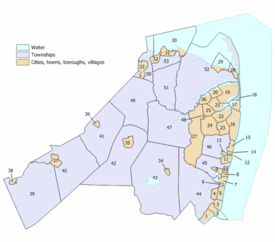
Municipalities in Monmouth County (with 2010 Census data for population, housing units and area in square miles) are listed below.[66] Other, unincorporated communities in the county are listed next to their parent municipality. Many of these areas are census-designated places (labeled as CDPs) that have been created by the United States Census Bureau for enumeration purposes within a township, with the 2010 Census population listed. Other communities and enclaves that exist within a municipality are also listed.
| Municipality (w/ map index) |
Municipal type |
Population | Housing units |
Total area |
Water area |
Land area |
Pop. density |
Housing density |
Unincorporated communities |
|---|---|---|---|---|---|---|---|---|---|
| Aberdeen Township (50) | township | 18,210 | 7,102 | 7.77 | 2.33 | 5.45 | 3,343.0 | 1,303.8 | Cliffwood Cliffwood Beach CDP (3,194) Henningers Mills Strathmore CDP (7,258) |
| Allenhurst (14) | borough | 496 | 365 | 0.28 | 0.02 | 0.26 | 1,887.9 | 1,389.3 | |
| Allentown (38) | borough | 1,828 | 735 | 0.63 | 0.03 | 0.60 | 3,023.9 | 1,215.8 | |
| Asbury Park (11) | city | 16,116 | 8,076 | 1.60 | 0.18 | 1.42 | 11,319.5 | 5,672.4 | |
| Atlantic Highlands (29) | borough | 4,385 | 2,002 | 4.56 | 3.27 | 1.29 | 3,401.2 | 1,552.9 | Hilton Stone Church |
| Avon-by-the-Sea (8) | borough | 1,901 | 1,321 | 0.54 | 0.12 | 0.43 | 4,459.1 | 3,098.6 | |
| Belmar (7) | borough | 5,794 | 3,931 | 1.65 | 0.60 | 1.05 | 5,544.0 | 3,761.4 | |
| Bradley Beach (10) | borough | 4,298 | 3,180 | 0.63 | 0.02 | 0.61 | 7,023.6 | 5,196.6 | |
| Brielle (1) | borough | 4,774 | 2,034 | 2.37 | 0.62 | 1.76 | 2,717.5 | 1,157.8 | Manasquan Park |
| Colts Neck Township (47) | township | 10,142 | 3,735 | 31.79 | 1.06 | 30.73 | 330.0 | 121.5 | Bucks Mill Colonial Terrace Cooks Mills Montrose Phalanx Scobeyville Vanderburg |
| Deal (15) | borough | 750 | 926 | 1.32 | 0.08 | 1.24 | 604.8 | 746.7 | |
| Eatontown (24) | borough | 12,709 | 5,723 | 5.88 | 0.05 | 5.83 | 2,181.5 | 982.3 | |
| Englishtown (36) | borough | 1,847 | 647 | 0.59 | 0.02 | 0.57 | 3,245.7 | 1,137.0 | |
| Fair Haven (20) | borough | 6,121 | 2,065 | 2.11 | 0.51 | 1.60 | 3,832.5 | 1,292.9 | |
| Farmingdale (34) | borough | 1,329 | 578 | 0.52 | 0.00 | 0.52 | 2,547.7 | 1,108.0 | |
| Freehold Borough (35) | borough | 12,052 | 4,249 | 1.95 | 0.00 | 1.95 | 6,180.8 | 2,179.1 | |
| Freehold Township (42) | township | 36,184 | 13,140 | 38.73 | 0.22 | 38.50 | 939.8 | 341.3 | Burlington Heights East Freehold CDP (4,894) Georgia Orchard Estates Siloam Smithburg Stonehurst East Stonehurst West West Freehold CDP (13,613) |
| Hazlet Township (53) | township | 20,334 | 7,417 | 5.67 | 0.12 | 5.56 | 3,659.4 | 1,334.8 | Centerville Mechanicsville North Centerville Tiltons Corner Van Marters Corner West Keansburg |
| Highlands (28) | borough | 5,005 | 3,146 | 1.37 | 0.60 | 0.77 | 6,522.8 | 4,100.1 | Waterwitch |
| Holmdel Township (51) | township | 16,773 | 5,792 | 18.11 | 0.22 | 17.90 | 937.3 | 323.7 | Centerville Crawford Corners Everett Morrells Corner Pleasant Valley Crossroads |
| Howell Township (43) | township | 51,075 | 17,979 | 61.21 | 0.65 | 60.56 | 843.4 | 296.9 | Adelphia Ardena Ardmore Estates Bergerville Candlewood Collingwood Park Fairfield Fort Plains Freewood Acres Jerseyville Lake Club Land of Pines Larrabees Lower Squankum Matthews Maxim Oak Glen Parkway Pines Ramtown CDP (6,242) Salem Hill Shacks Corner Southard Squankum West Farms Winston Park Wyckoff Mills |
| Interlaken (13) | borough | 820 | 393 | 0.38 | 0.05 | 0.33 | 2,482.3 | 1,189.7 | |
| Keansburg (30) | borough | 10,105 | 4,318 | 16.79 | 15.72 | 1.07 | 9,452.3 | 4,039.1 | Tiltons Corner |
| Keyport (32) | borough | 7,240 | 3,272 | 1.47 | 0.07 | 1.40 | 5,188.4 | 2,344.8 | |
| Lake Como (6) | borough | 1,759 | 1,115 | 0.27 | 0.01 | 0.25 | 6,943.6 | 4,401.4 | |
| Little Silver (21) | borough | 5,950 | 2,278 | 3.32 | 0.61 | 2.71 | 2,197.3 | 841.3 | Little Silver Point |
| Loch Arbour (12) | village | 194 | 159 | 0.14 | 0.04 | 0.10 | 1,928.2 | 1,580.4 | |
| Long Branch (16) | city | 30,719 | 14,170 | 6.28 | 1.01 | 5.27 | 5,824.4 | 2,686.7 | Branchport East Long Branch Elberon North Long Branch Pier Village West End |
| Manalapan Township (41) | township | 38,872 | 13,735 | 30.84 | 0.23 | 30.61 | 1,270.0 | 448.8 | Clarks Mills Elton Gordons Corner Lafayette Mills Millhurst Monmouth Heights Oakland Mills Smithburg Taylors Mills Tennent Whittier Oaks Yorketown CDP (6,535) |
| Manasquan (2) | borough | 5,897 | 3,500 | 2.53 | 1.15 | 1.38 | 4,263.0 | 2,530.2 | |
| Marlboro Township (49) | township | 40,191 | 13,436 | 30.47 | 0.11 | 30.36 | 1,323.7 | 442.5 | Beacon Hill Bradevelt Claytons Corner Henningers Mills Herberts Corner Hillsdale Marlboro Monmouth Heights Montrose Morganville CDP (5,040) Mount Pleasant Pleasant Valley Robertsville CDP (11,297) Smocks Corner Spring Valley Wickatunk |
| Matawan (33) | borough | 8,810 | 3,606 | 2.40 | 0.14 | 2.26 | 3,896.6 | 1,594.9 | Freneau |
| Middletown Township (52) | township | 66,522 | 24,959 | 58.73 | 17.75 | 40.99 | 1,622.9 | 608.9 | Belford CDP (1,768) Chapel Hill East Keansburg Everett Fairview CDP (3,806) Harmony Hendrickson Corners Holland Leonardo CDP (2,757) Leonardville Lincroft CDP (6,135) Locust Monmouth Hills Navesink CDP (2,020) New Monmouth (28,689) North Middletown CDP (3,295) Oak Hill Philips Mills Port Monmouth CDP (3,818) Red Hill River Plaza Stone Church Tiltons Corner Town Brook |
| Millstone Township (40) | township | 10,566 | 3,434 | 37.27 | 0.68 | 36.59 | 288.8 | 93.9 | Bairdsville Bergen Mills Carrs Corner Carrs Tavern Charleston Springs Clarksburg Ely Elys Corner Fair Play Holmeson Perrineville Smithburg Stone Tavern Sweetman |
| Monmouth Beach (17) | borough | 3,279 | 1,981 | 2.07 | 0.99 | 1.08 | 3,049.5 | 1,842.4 | Galilee |
| Neptune Township (45) | township | 27,935 | 12,991 | 8.67 | 0.49 | 8.18 | 3,414.3 | 1,587.8 | Bradley Park Green Grove Hamilton Ocean Grove CDP (3,342) Shark River Hills CDP (3,697) West Grove |
| Neptune City (9) | borough | 4,869 | 2,312 | 0.95 | 0.00 | 0.95 | 5,105.0 | 2,424.0 | |
| Ocean Township (46) | township | 27,291 | 11,541 | 11.00 | 0.12 | 10.88 | 2,509.1 | 1,061.1 | Cold Indian Springs Deal Park Dogs Corners Elberon Park Green Grove Oakhurst CDP (3,995) Oakhurst Manor Wanamassa CDP (4,532) Wayside Wertheins Corner West Allenhurst (1,934) West Deal |
| Oceanport (22) | borough | 5,832 | 2,390 | 3.80 | 0.62 | 3.18 | 1,833.7 | 751.5 | Port-au-peck Sands Point |
| Red Bank (26) | borough | 12,206 | 5,381 | 2.16 | 0.42 | 1.74 | 7,019.1 | 3,094.4 | |
| Roosevelt (37) | borough | 882 | 327 | 1.92 | 0.01 | 1.91 | 461.8 | 171.2 | |
| Rumson (19) | borough | 7,122 | 2,585 | 7.12 | 2.06 | 5.06 | 1,408.0 | 511.0 | Oceanic Waterloo |
| Sea Bright (18) | borough | 1,412 | 1,211 | 1.29 | 0.56 | 0.73 | 1,935.5 | 1,659.9 | Low Moor Navesink Beach Normandie |
| Sea Girt (3) | borough | 1,828 | 1,291 | 1.45 | 0.39 | 1.06 | 1,729.6 | 1,221.5 | |
| Shrewsbury Borough (25) | borough | 3,809 | 1,310 | 2.20 | 0.03 | 2.17 | 1,757.2 | 604.4 | |
| Shrewsbury Township (48) | township | 1,141 | 648 | 0.10 | 0.00 | 0.10 | 10,877.7 | 6,177.7 | |
| Spring Lake (5) | borough | 2,993 | 2,048 | 1.73 | 0.40 | 1.33 | 2,250.8 | 1,540.2 | North Spring Lake |
| Spring Lake Heights (4) | borough | 4,713 | 2,972 | 1.31 | 0.03 | 1.28 | 3,671.3 | 2,315.1 | Villa Park |
| Tinton Falls (27) | borough | 17,892 | 8,766 | 15.62 | 0.14 | 15.49 | 1,155.3 | 566.0 | Green Grove Hockhockson Macedonia Pine Brook Reevytown Wayside West Shrewsbury Wileys Corner |
| Union Beach (31) | borough | 6,245 | 2,269 | 1.89 | 0.09 | 1.80 | 3,461.5 | 1,257.7 | Natco Van Marters Corner |
| Upper Freehold Township (39) | township | 6,902 | 2,458 | 47.23 | 0.82 | 46.42 | 148.7 | 53.0 | Arneytown Cooleys Corner Cream Ridge Ellisdale Emleys Hill Homes Mills Hornerstown Imlaystown Kirbys Mills Nelsonville New Canton New Sharon Polhemustown Pullentown Red Valley Robinsville Sharon Shrewsbury Spring Mill Walnford Wrightsville |
| Wall Township (44) | township | 26,164 | 10,883 | 31.74 | 1.06 | 30.67 | 853.0 | 354.8 | Algers Mills Allaire Allenwood CDP (925) Baileys Corner Blansingburg Carmerville Collingwood Park Glendola New Bedford Osbornes Mills Remsen Mills Sterling Woods West Belmar CDP (2,493) |
| West Long Branch (23) | borough | 8,097 | 2,528 | 2.89 | 0.04 | 2.86 | 2,832.9 | 884.5 | |
| Monmouth County | county | 630,380 | 258,410 | 665.32 | 196.53 | 468.79 | 1,344.7 | 551.2 |
Fire departments
Monmouth County is covered by 53 different fire departments, which contain 135 individual fire companies and over 7,000 volunteer firefighters, who are all represented by the Monmouth County Firemen's Association.[67]
The Monmouth County Fire Marshal's Office is responsible for training all of the firefighters through the Monmouth County Fire Academy, as well as investigating any fires which may be deemed suspicious and/or involving a fatality. The Monmouth County fire marshal, currently Kevin Stout, and his staff – including assistant fire marshals and academy staff – are appointed by the County Board of Chosen Freeholders.[68]
With the exception of the fully paid Asbury Park Fire Department and the US Navy Fire Department at NWS Earle, the remainder of the municipalities in the county have volunteer or combination fire departments.[69] The largest volunteer department is in Middletown Township with 11 stations and 350 active members, special services, air and fire police units, in addition to operating its own training facility.[70]
In terms of hazardous material (HazMat) emergencies, very few towns, notably Middletown which has a special services unit, have special units to respond to these types of emergencies. Fort Monmouth responded to most HazMat cases prior to the closing of the base. Naval Weapons Station Earle is also available for HazMat incidents.
The oldest Fire Department in the County is the Hope Fire Company in Allentown, Organized in 1856, the newest Fire Department Holmdel Fire Co. No. 2 was established in 2006.
Monmouth County utilizes a mutual aid system, in which surrounding municipalities are available to send their resources to incidents where extra help or expertise is needed.[71]
Education
Monmouth University is a four-year private university located in West Long Branch that was founded in 1933 as Monmouth Junior College.[72][73]
Brookdale Community College is the two-year community college for Monmouth County, one of a network of 19 county colleges statewide. The school is located in the Lincroft section of Middletown Township, having been founded in 1967.[74] Rutgers University has a partnership with Brookdale which offers bachelor's degree completion programs at Brookdale's Freehold campus.[75]
In addition to multiple public high schools, parochial schools in Monmouth County include St. Rose High School, Red Bank Catholic High School, Christian Brothers Academy, St. John Vianney High School, and Mater Dei High School, which operate under the auspices of the Roman Catholic Diocese of Trenton.[76] A secular private school, Ranney School, is also located here.
The county has an extensive vocational high school program, known as the Monmouth County Vocational School District, including five magnet schools:[77]
- Academy of Allied Health & Science (Allied) in Neptune Township
- Biotechnology High School (BioTech) in Freehold Township
- Communications High School (Communications, CHS) in Wall Township
- High Technology High School (High Tech) in Lincroft (located on the Brookdale Community College campus)
- Marine Academy of Science and Technology (MAST) in Sandy Hook
Climate and weather
| Freehold Borough, New Jersey | ||||||||||||||||||||||||||||||||||||||||||||||||||||||||||||
|---|---|---|---|---|---|---|---|---|---|---|---|---|---|---|---|---|---|---|---|---|---|---|---|---|---|---|---|---|---|---|---|---|---|---|---|---|---|---|---|---|---|---|---|---|---|---|---|---|---|---|---|---|---|---|---|---|---|---|---|---|
| Climate chart (explanation) | ||||||||||||||||||||||||||||||||||||||||||||||||||||||||||||
| ||||||||||||||||||||||||||||||||||||||||||||||||||||||||||||
| ||||||||||||||||||||||||||||||||||||||||||||||||||||||||||||
Monmouth County has a humid subtropical climate. In recent years, average temperatures in the county seat of Freehold Borough have ranged from a low of 22 °F (−6 °C) in January to a high of 86 °F (30 °C) in July, although a record low of −13 °F (−25 °C) was recorded in January 1984 and a record high of 106 °F (41 °C) was recorded in July 2011. Average monthly precipitation ranged from 2.98 inches (76 mm) in February to 5.08 inches (129 mm) in July.[78]
On October 29, 2012, Hurricane Sandy caused catastrophic damage to coastal areas of Monmouth County. As Sandy's surge arrived in Monmouth County, flood levels of 13.31 feet (4.06 m) above normal were measured at Sandy Hook shortly before the destruction of the tidal station, breaking all previous local records. The surge caused waves as high as 32.5 feet (9.9 m), measured where the Sandy Hook Bay meets the New York Bay.[79]
Wineries, breweries and distilleries
- Basil T's Brewery
- Carton Brewing
- Cream Ridge Winery
- Four JG's Orchards & Vineyards
- Kane Brewing
- Laird & Company
- Peppadew Fresh Vineyards
See also
- USS Monmouth County (LST-1032)
- Monmouth County Historical Association
- National Register of Historic Places listings in Monmouth County, New Jersey
- List of Monmouth County Freeholder directors
Footnotes
- 1 2 Monmouth County, NJ, National Association of Counties. Accessed January 21, 2013.
- 1 2 3 4 5 DP1 - Profile of General Population and Housing Characteristics: 2010 Demographic Profile Data for Monmouth County, New Jersey, United States Census Bureau. Accessed March 25, 2016.
- 1 2 3 State & County QuickFacts - Monmouth County, New Jersey, United States Census Bureau. Accessed July 3, 2016.
- ↑ NJ Labor Market Views, New Jersey Department of Labor and Workforce Development, March 15, 2011. Accessed October 7, 2013.
- 1 2 3 4 New Jersey: 2010 - Population and Housing Unit Counts; 2010 Census of Population and Housing, p. 6, CPH-2-32. United States Census Bureau, August 2012. Accessed August 29, 2016.
- ↑ PEPANNRES: Annual Estimates of the Resident Population: April 1, 2010 to July 1, 2014 - 2014 Population Estimates for New Jersey, United States Census Bureau. Accessed May 12, 2015.
- ↑ "Find a County". National Association of Counties. Retrieved June 7, 2011.
- ↑ Staff. "Highest income counties in 2011", The Washington Post, September 19, 2012. Accessed October 31, 2012.
- ↑ 250 Highest Per Capita Personal Incomes of the 3113 Counties in the United States, 2009, Bureau of Economic Analysis. Accessed April 9, 2012.
- ↑ Salter, Edwin (1890). History of Monmouth and Ocean Counties. p. 5.
- ↑ Freehold Township, Monmouth County, New Jersey. Accessed July 12, 2012.
- 1 2 Hodges, Graham Russell. Slavery and Freedom in the Rural North: African Americans in Monmouth County, New Jersey, 1665–1865, p. 32. Madison, WI: Madison House, 1997. ISBN 9780945612513. Accessed October 7, 2013.
- 1 2 Snyder, John P. The Story of New Jersey's Civil Boundaries: 1606-1968, Bureau of Geology and Topography; Trenton, New Jersey; 1969. p. 177. Accessed October 1, 2013.
- ↑ The Origin of New Jersey Place Names: M, GetNJ.com. Accessed December 15, 2007.
- ↑ How Monmouth County Got Its Name, Monmouth County, New Jersey. Accessed August 14, 2008.
- ↑ Capuzzo, Jill P. "British Beware: Monmouth Redux", The New York Times, May 18, 2003. Accessed April 9, 2012. "The largest land artillery battle of the Revolutionary War, the Battle of Monmouth marked a significant turning point in the colonies' fight against the British crown."
- ↑ Census 2010 U.S. Gazetteer Files: New Jersey Counties, United States Census Bureau. Accessed May 12, 2015.
- ↑ New Jersey County High Points, Peakbagger.com. Accessed October 5, 2013.
- ↑ Staff. "Holmdel by the numbers", Asbury Park Press, October 21, 1999. Accessed October 1, 2013. "391: Number of feet above sea level at Crawford Hill, the highest point in Monmouth County"
- ↑ Bell Labs Research in the United States, Alcatel-Lucent. Accessed October 7, 2013. "Bell Labs researchers work in several locations across the United States, including:Murray Hill, New Jersey; Holmdel (Crawford Hill), New Jersey"
- ↑ About U.S. Coast Guard Station Manasquan, United States Coast Guard. Accessed October 7, 2013. "The Manasquan Inlet also is the Northern terminus of the Intracoastal Waterway which means that on any summer weekend as many as 1600 boats may pass through it."
- ↑ Areas touching Monmouth County, MapIt. Accessed May 12, 2015.
- ↑ Annual Estimates of the Resident Population: April 1, 2010 to July 1, 2015 - 2015 Population Estimates, United States Census Bureau. Accessed July 3, 2016.
- ↑ Forstall, Richard L. Population of states and counties of the United States: 1790 to 1990 from the Twenty-one Decennial Censuses, pp. 108-109. United States Census Bureau, March 1996. ISBN 9780934213486. Accessed October 7, 2013.
- 1 2 3 4 DP-1 - Profile of General Demographic Characteristics: 2000; Census 2000 Summary File 1 (SF 1) 100-Percent Data for Monmouth County, New Jersey, United States Census Bureau. Accessed January 22, 2013.
- ↑ U.S. Census Bureau Delivers New Jersey's 2010 Census Population Totals, United States Census Bureau, February 3, 2011. Accessed February 5, 2011.
- ↑ "American FactFinder". United States Census Bureau. Retrieved January 31, 2008.
- 1 2 3 Tables DP-1 to DP-4 from Census 2000 for Monmouth County, New Jersey, United States Census Bureau. Accessed October 1, 2013.
- ↑ DP-2 - Profile of Selected Social Characteristics: 2000 from the Census 2000 Summary File 3 (SF 3) - Sample Data for Monmouth County, New Jersey, United States Census Bureau. Accessed September 30, 2013.
- ↑ DP-3 - Profile of Selected Economic Characteristics: 2000 from Census 2000 Summary File 3 (SF 3) - Sample Data for Monmouth County, New Jersey, United States Census Bureau. Accessed September 30, 2013.
- 1 2 Board of Chosen Freeholders, Monmouth County, New Jersey. Accessed May 12, 2015.
- ↑ County Administrator Teri O'Connor, Monmouth County, New Jersey. Accessed May 12, 2015.
- ↑ Freeholder Gary J. Rich Sr., Monmouth County, New Jersey. Accessed February 4, 2014.
- ↑ Freeholder Deputy Director Serena DiMaso, Monmouth County, New Jersey. Accessed May 12, 2015.
- ↑ Freeholder Director Thomas A. Arnone, Monmouth County, New Jersey. Accessed May 12, 2015.
- ↑ Freeholder Lillian G. Burry, Monmouth County, New Jersey. Accessed May 12, 2015.
- ↑ Freeholder John P. Curley, Monmouth County, New Jersey. Accessed May 12, 2015.
- ↑ Office of the County Clerk, Monmouth County, New Jersey. Accessed May 12, 2015.
- ↑ Sheriff Shaun Golden, Monmouth County Sheriff's Office. Accessed May 12, 2015.
- ↑ Office of the Monmouth County Surrogate, Monmouth County, New Jersey. Accessed May 12, 2015.
- ↑ Meet the Prosecutor, Monmouth County, New Jersey. Accessed May 12, 2015.
- ↑ "Welcome to the New Jersey Court System". New Jersey Courts. New Jersey Courts. Retrieved 28 February 2016.
- ↑ "Local Court Addresses". New Jersey Courts. New Jersey Courts. Retrieved 28 February 2016.
- ↑ New Jersey Courts. New Jersey Courts http://www.judiciary.state.nj.us/monmouth/index.htm. Retrieved 28 February 2016. Missing or empty
|title=(help) - ↑ 2012 Congressional Districts by County, New Jersey Department of State Division of Elections. Accessed October 7, 2013.
- ↑ Plan Components Report, New Jersey Department of State Division of Elections, December 23, 2011. Accessed October 7, 2013.
- ↑ Directory of Representatives: New Jersey, United States House of Representatives. Accessed January 5, 2012.
- ↑ Directory of Representatives: New Jersey, United States House of Representatives. Accessed January 5, 2012.
- ↑ 2011 Legislative Districts by County, New Jersey Department of State Division of Elections. Accessed October 7, 2013.
- ↑ Legislative Roster 2016-2017 Session, New Jersey Legislature. Accessed January 17, 2016.
- ↑ Legislative Roster 2016-2017 Session, New Jersey Legislature. Accessed January 17, 2016.
- ↑ Legislative Roster 2016-2017 Session, New Jersey Legislature. Accessed January 17, 2016.
- ↑ Legislative Roster 2016-2017 Session, New Jersey Legislature. Accessed January 17, 2016.
- 1 2 Statewide Voter Registration Summary, New Jersey Department of State Division of Elections, as of October 31, 2014. Accessed May 11, 2015.
- ↑ GCT-P7: Selected Age Groups: 2010 - State -- County / County Equivalent from the 2010 Census Summary File 1 for New Jersey, United States Census Bureau. Accessed May 11, 2015.
- ↑ 2010 General Election Winners of County Offices Monmouth County, New Jersey Department of State Division of Elections, February 22, 2011. Accessed October 1, 2013.
- ↑ New Jersey Presidential Election Returns by County 2004, Eagleton Institute of Politics at Rutgers University. Accessed August 31, 2008.
- ↑ U.S. Election Atlas
- ↑ Monmouth County Mileage by Municipality and Jurisdiction, New Jersey Department of Transportation, May 2010. Accessed July 24, 2014.
- ↑ U.S. Route 9 Straight Line Diagram, New Jersey Department of Transportation, May 2008. Accessed February 4, 2014.
- ↑ Interstate 195 Straight Line Diagram, New Jersey Department of Transportation, February 2010. Accessed November 20, 2014.
- ↑ Garden State Parkway Straight Line Diagram, New Jersey Department of Transportation, January 1997. Accessed February 4, 2014.
- ↑ Travel Resources: Interchanges, Service Areas & Commuter Lots, New Jersey Turnpike Authority. Accessed October 7, 2013.
- ↑ North Jersey Coast Line, New Jersey Transit. Accessed October 7, 2013.
- ↑ Dock & Roll Shuttle Bus Local Service Schedule, Monmouth County, New Jersey. Accessed February 4, 2014.
- ↑ GCT-PH1: Population, Housing Units, Area, and Density: 2010 - County -- County Subdivision and Place from the 2010 Census Summary File 1 for Monmouth County, New Jersey, United States Census Bureau. Accessed August 24, 2014.
- ↑ Monmouth County Fire Service Directory - 2012, Monmouth County Fire Marshal's Office. Accessed October 1, 2013.
- ↑ Home Page, Monmouth County Fire Marshal's Office. Accessed October 1, 2013.
- ↑ Kaplan, Dan. "Wall's Glendola company hires fireman, a first", copy of article from Asbury Park Press, September 1, 2005, at Firehouse.com. Accessed September 1, 2005. "Asbury Park's fire department is Monmouth County's only fully paid one. With 42 members, the department carries an annual budget of about $3.7 million and responds to about 6,100 annual calls, Assistant City Manager James Famularo said. While the tax burden in Asbury Park is greater than that in towns with volunteer squads, the city needs a full-time presence, Battalion Chief Kevin Keddy said. The Fire Department also includes the city's emergency medical technicians."
- ↑ Home page, Middletown Township Fire Department. Accessed April 9, 2012.
- ↑ MARP, Monmouth County Sheriff's Office. Accessed February 12, 2014.
- ↑ Location Is Everything, Monmouth University. Accessed October 7, 2013.
- ↑ Monmouth University: Generations of Excellence 1933-2013, Monmouth University. Accessed October 7, 2013.
- ↑ About Brookdale, Brookdale Community College. Accessed October 7, 2013. "The College was founded in 1967 and is sponsored by the citizens of Monmouth County through the Board of Chosen Freeholders."
- ↑ The power of Rutgers, locally., Rutgers University. Accessed April 9, 2012.
- ↑ School Directory, Roman Catholic Diocese of Trenton. Accessed April 9, 2012.
- ↑ Full-Time Specialized Schools, Monmouth County Vocational School District. Accessed October 7, 2013.
- 1 2 "Monthly Averages for Freehold Borough, New Jersey". The Weather Channel. Retrieved October 13, 2012.
- ↑ Freedman, Andrew. "32-Foot-Plus Waves From Hurricane Sandy Topple Records", Climate Central, November 14, 2012. Accessed October 7, 2013. "The harbor entrance buoy recorded a significant wave height of 32.5 feet at 8:50 pm on Oct. 29, beating the previous record set during Hurricane Irene by 6.5 feet!... Sandy Hook, N.J., which is a spit of land that juts into the Atlantic pointing toward New York City from the extreme northeastern part of the state, also saw record coastal flooding during Sandy. The water level there rose to 13.31 feet above the average low tide level before the gauge malfunctioned."
Further reading
- Graham Russell Hodges, Slavery and Freedom in the Rural North: African Americans in Monmouth County, New Jersey, 1665-1865 Madison, WI: Madison House, 1997
- Charles A. Philhower, Indians of Monmouth County, New Jersey. (1924) Morristown, NJ: Digital Antiquaria, 2006.
- Edwin Salter, A History of Monmouth and Ocean Counties Embracing a Genealogical Record of Earliest Settlers of Monmouth and Ocean Counties and Their Descendants; The Indians: Their Language, Manners, and Customs; Important Historical Events: The Revolutionary War, Battle of Monmouth, The War of the Rebellion: Names of Officers and Men of Monmouth and Ocean Counties Engaged in It, etc., etc. Bayonne, NJ: E. Gardner and Son, 1890.
- Charles A. Philhower, Indians of Monmouth County, New Jersey. (1924) Morristown, NJ: Digital Antiquaria, 2006.
External links
| Wikimedia Commons has media related to Monmouth County, New Jersey. |
| Wikivoyage has a travel guide for Monmouth County. |
 |
Middlesex County | Richmond County, New York | Queens County, New York | |
| Mercer County | |
Atlantic Ocean | ||
| ||||
| | ||||
| Burlington County | Ocean County |
Coordinates: 40°17′N 74°09′W / 40.29°N 74.15°W