Mont Granier
| Mont Granier | |
|---|---|
 | |
| Highest point | |
| Elevation | 1,933 m (6,342 ft) |
| Coordinates | 45°27′53″N 05°55′31″E / 45.46472°N 5.92528°ECoordinates: 45°27′53″N 05°55′31″E / 45.46472°N 5.92528°E |
| Geography | |
 Mont Granier Location in the Alps | |
| Location | Savoie and Isère, France |
| Parent range | Chartreuse Mountains |

Mont Granier (1,933m) is a limestone mountain located between the départements of Savoie and Isère in France. It lies in the Chartreuse Mountains range of the French Prealps between the towns of Chapareillan and Entremont-le-Vieux. Its east face overlooks the valley of Grésivaudan and Combe de Savoie, and the north face overlooks Chambéry. At 900 meters tall, Mont Granier has one of the highest cliffs in France.
Landslides
Catastrophic 1248 Landslide
In the year 1248, between November 24–25, a mass of limestone resting on marls slid into the valley, causing a massive landslide that destroyed many villages and caused over a thousand casualties, although the numbers are still debated.[1][2] This event created the sheer 700 m north face of the mountain.
Five villages were partly or completely destroyed by the avalanche:
Two villages were partially destroyed:
- Myans
- Les Murs (Les Marches)
The 1248 Landslide was one of the biggest and deadliest landslides in Europe.
January 9, 2016 Landslide
In the night of between January 8-9, 2016, a part of the northwest pillar crumbled towards Entremont-le-Vieux, where residents woke up at 5 in the morning. The collapse was of about 170,000 cubic meters of rock. The last debris were stopped by trees within 300 m of the closest houses, lying in the hamlets of Brancaz and Tencovaz.
Activities
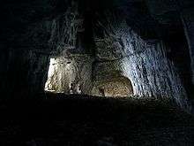
It is a popular spot for hiking, caving, rock climbing, and BASE jumping. The mountain contains the cave system le Systeme du Granier, which is over 55 kilometres (34 mi) long, and 564 metres (1,850 ft) deep.[3]
On November 13, 1988, cavers Pierre Guichebaron and Marc Papet discovered an extension to the Balme à Collomb cave on the west side of the mountain at an altitude of 5,577 feet (1,700 meters) that contained the skeletons of over 1,000 cave bears that date between 24,000 and 45,000 years.
Around the base of Mont Granier are many vineyards that produce the Apremont and Abymes appellations. These wines are made from the white Jacquère grape, seldom used outside Savoie.
The Col du Granier (1,134 m.) crosses the ridge to the north-west of the mountain.
References
- ↑ de Blasio, Fabio Vittorio (2011). Introduction to the Physics of Landslides. Springer. p. 161. ISBN 978-94-007-1121-1.
- ↑ "Geomorphic impacts of large and rapid mass movements: a review". Geomorphologie.revues.org. Retrieved 2012-07-24.
- ↑ "World's Longest Caves". Bob Gulden. Retrieved 2012-07-13.
External links
| Wikimedia Commons has media related to Mont Granier. |
- Walks on Mont Granier
- BASE jumping from Mont Granier - YouTube video
- Jacquère - Vin de Savoie, Abymes, France
- A Wine Tour in the French Alps
- Wines from the Combe de Savoie, Mont Granier & Jongieux