Monte Bo
| Monte Bo | |
|---|---|
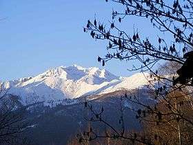 Mount Bo from Colma di Biella | |
| Highest point | |
| Elevation | 2,556 m (8,386 ft) [1] |
| Prominence | 613 m (2,011 ft) [1][2] |
| Listing | Alpine mountains 2500-2999 m |
| Coordinates | 45°42′54″N 07°59′55″E / 45.71500°N 7.99861°ECoordinates: 45°42′54″N 07°59′55″E / 45.71500°N 7.99861°E |
| Geography | |
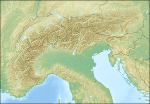 Monte Bo Location in the Alps | |
| Location | Province of Biella, Italy |
| Parent range | Alpi Biellesi |
| Climbing | |
| Easiest route | from Piedicavallo |
Monte Bo (or Cima di Bo) is a mountain in the Alpi Biellesi, a sub-range of Pennine Alps.
Geography
The mountain is located between Sessera and Cervo valleys and is totally included in the province of Biella. It is divided between the comune of Piedicavallo and the mountain exclaves of Pettinengo, Tavigliano and Valle San Nicolao.
SOIUSA classification
According to the SOIUSA (International Standardized Mountain Subdivision of the Alps) the mountain can be classified in the following way:[3]
- main part = Western Alps
- major sector = North Western Alps
- section = Pennine Alps
- subsection = Southern Valsesia Alps
- supergroup = Alpi Biellesi
- group = Catena Tre Vescovi - Mars
- subgroup = Costiera Bo-Cravile-Monticchio
- code = I/B-9.IV-A.2.b
With an elevation of 2,556 m it's the second highest peak of the Province of Biella after Monte Mars (2,600 m).
Access to the summit
The easiest route for the summit is a long but well marked footpath starting from Montesinaro, a village belonging to Piedicavallo township. Nearby the mountain's top is located Bivacco Antoniotti, an emergency mountain shelter.
Maps
- Italian official cartography (Istituto Geografico Militare - IGM); on-line version: www.pcn.minambiente.it
- Provincia di Biella cartography: Carta dei sentieri della Provincia di Biella, 1:25.00 scale, 2004; on line version: webgis.provincia.biella.it
References
- 1 2 Geoportale IGM on www.pcn.minambiente.it
- ↑ key col: Bocchetta del Croso (1,943 m)
- ↑ Marazzi, Sergio (2005). Atlante Orografico delle Alpi. SOIUSA (in Italian). Priuli & Verlucca. p. 134. ISBN 978-88-8068-273-8.