Montigny-le-Bretonneux
| Montigny-le-Bretonneux | ||
|---|---|---|
|
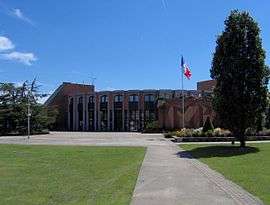
The city hall | ||
| ||
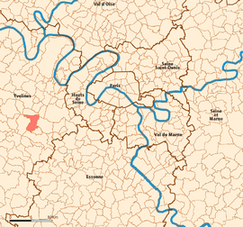 Location (in red) within Paris inner and outer suburbs | ||
| Coordinates: 48°46′16″N 2°02′00″E / 48.7711°N 2.0333°ECoordinates: 48°46′16″N 2°02′00″E / 48.7711°N 2.0333°E | ||
| Country | France | |
| Region | Île-de-France | |
| Department | Yvelines | |
| Arrondissement | Versailles | |
| Canton | Montigny-le-Bretonneux | |
| Intercommunality | Saint-Quentin-en-Yvelines | |
| Government | ||
| • Mayor | Michel Laugier | |
| Area1 | 11.65 km2 (4.50 sq mi) | |
| Population (2006)2 | 34,591 | |
| • Density | 3,000/km2 (7,700/sq mi) | |
| Time zone | CET (UTC+1) | |
| • Summer (DST) | CEST (UTC+2) | |
| INSEE/Postal code | 78423 / 78180 | |
| Elevation | 150–171 m (492–561 ft) | |
|
1 French Land Register data, which excludes lakes, ponds, glaciers > 1 km² (0.386 sq mi or 247 acres) and river estuaries. 2 Population without double counting: residents of multiple communes (e.g., students and military personnel) only counted once. | ||
.svg.png)
Montigny-le-Bretonneux is a commune in the Yvelines department in the Île-de-France region in north-central France. It is located in the south-western suburbs of Paris, 24.5 kilometres (15.2 miles) from the centre of Paris, in the "new town" of Saint-Quentin-en-Yvelines, of which it is the central and most populated commune.
History
Montigny le Bretonneux, the 6th town of the Yvelines department, has 36000 inhabitants and is the central and principal town of the district Saint-Quentin-en-Yvelines. It is ideally situated at the heart of Yvelines, formed in the shape of a triangle in the south by la Vallee de Chevreuse and the massif forestier de Rambouillet, and the towns of Versailles and Saint Germain en Laye in the north.
The history of the town reflects that of a small traditional French village, naturally devoted to agriculture; "the best wheat lands of France". The growth of the new town in the 1970s actually initiates the change from the village of Montigny-le-Bretonneux (1292 inhabitants in 1970) to the town (10,063 in 1980).
The town is found 25 km (16 miles) south west of Paris, and 5 km (3 miles) from Versailles, and at the heart of an agglomeration of 150,000 people, of which Montigny is the largest with 36000 inhabitants.
After two decades of steady urbanization, Montigny-le-Bretonneux is now essentially completed, although the opportunity to create new housing is still there. In 2002, the State has decreed the end of the Operation of National Interest Statute establishing the new district of Saint-Quentin-en-Yvelines, whose seven member municipalities have opted for a new intercommunal principal, the “Community of Agglomeration”.
Montigny le Bretonneux has now passed the building phase – the frenzy of building that characterised the town is suitably balanced between neighbourhoods and business areas. Montigny has become a haven for St. Quentinois wishing to settle there. The parks were born in the 1970s and 1980s with the rise of the new town are and were in principle built to rehabilitate the economic heritage and to adapt to technological standards now imposed on businesses. Its economy is rooted primarily in the service sector (1,590 businesses). Furthermore, several major headquarters of international companies have settled in the city (for example; SAIPEM, BMW France et COGEMA).
The future of Montigny le Bretonneux emerges in particular arrival of the national velodrome by early 2013, supported by the State, the French Cycling Federation, local authorities and a pool of business partners. The building of the future Faculty of Medicine, Faculty of Medicine Paris-Ile de France-West will be completed for the start of 2012.
Events in the town
The town organises annual events for which the community comes together to celebrate. Some are listed below:
- Le Vide-greniers ; literally Empty Lofts ! This important occasion happens in spring on the avenue Nicolas About:[1]
- La Journée de l’Europe : organised in May, this day celebrates all European values. All the schools, universities, businesses, homes and societies join to celebrate the diversity with song, food and dancing.
- La Cavalcade – this is a huge event in the Montigny calendar in all quarters of the town. The municipal services and varying associations of Montigny come together for La cavalcade, perhaps known in Britain as the Montigny Carnival. Each carnival is based on a theme and is held every two years. The day is divided into three main events; the morning sees the town’s neighbourhoods come alive whilst the actual parade itself takes place in the afternoons. The evening sees spectacular performances at the Ferme de Manet.
- La Vesprée takes places every other year when the Carnival does not. Similar to a large garden party, these soirées take place honouring educational and recreational aspects.
- The Fire of Saint John is organized the same year as the vespers. At dusk, this evening celebrates the summer solstice. Everyone is invited to light the bonfire, whose flames are a celebration of light, and dance to the rhythm of a popular dance.
- Day Auto-Moto Retro: this event organised by Montigny le Bretonneux and the Association of Old Pistons is normally held in early September. It is a parade of vintage vehicles whose owners are proud to present and discuss their "little miracles". These demonstrations are followed by a competition of elegance!
- Marché de Noël : For three days the Ferme du Manet installs a fantasy village in a magical setting of trees and light. A winter wonderland of gifts and crafts is put on within the village.
- Paris-Brest-Paris : A 1,200 km bicycle ride that takes place every 4 years, in late summer.
Transport
Montigny-le-Bretonneux is served by Saint-Quentin-en-Yvelines station on Paris RER line C, on the Transilien La Défense suburban rail line, and on the Transilien Paris – Montparnasse suburban rail line.
Neighbourhoods
The community has nine neighbourhoods. They are Manet, Pas du Lac, Plan de l'Eglise, Plan de Troux Prés, Saint Quentin, Sourderie Nord, Sourderie Sud, and Village.[2]
Education
15 schools serve école maternelle (preschool) students, and 15 schools serve école élémentaire (elementary) students. There are two groupes scolaires, or combined preschools and elementary schools.[3]
Public secondary schools:
- Junior high schools: Collège Alberto Giacometti,[4] Collège de La Couldre,[5] Collège Les Prés.[6]
- Lycée Descartes de Montigny le Bretonneux is located in the city.
Private schools:
- Collège Lycées Saint François d'Assise[7]
- Institut de formation de Saint-Quentin-en-Yvelines
- The Institut culturel franco-japonais, a Japanese international school (elementary and junior high school), is in the commune.
The Town Logo
The rainbow symbolises the radiance and vitality of the town. The dominant green colour symbolises the green space of the community, and the Ferme du Manet and leisure facilities in the town. The four white stones and lily are the historical reference; under l’ancien Regime, important boundaries marking royal properties were marked with a white stone, engraved with initials or a crest. At Montigny, the crest was a lily flower. Four were planted at a crossroads leading to Versailles, Trappes, Montigny and Bois d’Arcy.
International relations
Twin towns – Sister cities
Montigny-le-Bretonneux is twinned with:
|
See also
References
- ↑ call befor :Avenue du Pas du Lac
- ↑ "Présentation de la ville." Montigny-le-Bretonneux. Retrieved on 27 December 2011.
- ↑ "Écoles maternelles-primaires." City of Montigny-le-Bretonneux. Retrieved on 27 December 2011.
- ↑ Home. Collège Alberto Giacometti. Retrieved on September 4, 2016.
- ↑ Home. Collège de La Couldre. Retrieved on September 4, 2016.
- ↑ Home. Collège Les Prés. Retrieved on September 4, 2016.
- ↑ Home. Collège Lycées Saint François d'Assise. Retrieved on September 4, 2016.
External links
| Wikimedia Commons has media related to Montigny-le-Bretonneux. |