Montmeneu
| Montmeneu | |
|---|---|
 | |
| Highest point | |
| Elevation | 494.63 m (1,622.8 ft) |
| Coordinates | 41°23′19″N 0°24′05″E / 41.38861°N 0.40139°ECoordinates: 41°23′19″N 0°24′05″E / 41.38861°N 0.40139°E |
| Geography | |
 Montmeneu Catalonia, Spain | |
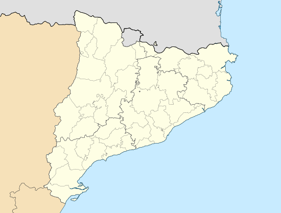
| Location | Segrià, Catalonia |
| Parent range | Isolated hill in the Catalan Central Depression |
| Geology | |
| Mountain type | Conglomerate |
| Climbing | |
| First ascent | Unknown |
| Easiest route | From La Granja d'Escarp, Seròs or Maials |
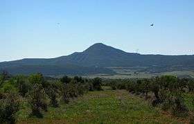
Montmeneu (Catalan pronunciation: [mumːəˈnew], locally: [momːeˈnew]) or Punta de Montmaneu is a mountain in Catalonia, Spain. It is located within the La Granja d'Escarp and Seròs municipal limits, Segrià. Montmeneu is an isolated hill of the Catalan Central Depression.[1] Since it is surrounded by flat landscape the mountain is visible over long distances.
There is a triangulation station at the top marked "247126001". Although it is not the highest hill in the region —the Puntal dels Escambrons is 5 m higher— the top offers a magnificent view of the surrounding landscape.[2]
This mountain is one of the Emblematic summits of Catalonia.[3]
See also
References
- ↑ "Mapa Topogràfic de Catalunya". Institut Cartogràfic de Catalunya. Retrieved May 22, 2010.
- ↑ Cims comarcals: Segrià. Montmeneu
- ↑ Llista 100 cims - Institut Cartogràfic i Geològic de Catalunya
External links
- Map Segrià, ICC 1:50.000
- Wikiloc - Montmeneu hiking route
This article is issued from Wikipedia - version of the 8/8/2016. The text is available under the Creative Commons Attribution/Share Alike but additional terms may apply for the media files.