Monument Rocks (Kansas)
| Monument Rocks | |
| Protected Area | |
 View of the Monument Rocks | |
| Country | |
|---|---|
| State | |
| Region | Smoky Hills |
| District | Gove County |
| City | South of Oakley, Kansas |
| River | Smoky Hill River |
| Elevation | 802 m (2,631 ft) |
| Coordinates | 38°47′26″N 100°45′45″W / 38.79056°N 100.76250°WCoordinates: 38°47′26″N 100°45′45″W / 38.79056°N 100.76250°W |
| Biome | Temperate grassland |
| Geology | Niobrara Chalk (erosional remnant) |
| Period | Late Cretaceous |
| Plant | Tallgrass prairie |
| Animal | Whitetail, Pronghorn, Prairie Dog, Coyote |
| Designated | National Natural Landmark |
| Date | 1968 |
| Owner | Private property |
 Map showing location of Monument Rocks | |
| Website: Washburn University website | |
| Designated | 1968 |
Monument Rocks (also Chalk Pyramids) are a series of large chalk formations in Gove County, Kansas, rich in fossils. The formations were the first landmark chosen by the US Department of the Interior as a National Natural Landmark. The chalk formations reach a height of up to 70 ft (21 m) and include formations such as buttes and arches. The carbonate deposits were laid down during the Cretaceous Period in what was then the Western Interior Seaway, which split the continent of North America into two landmasses. They are estimated to have been formed 80 million years ago.
History
On January 29, 2008, Monument Rocks, 25 miles south of Oakley, Kansas, and Castle Rock, 31 miles to the east, were jointly named as one of the 8 Wonders of Kansas.[1]
Gallery
 Wide view of largest formation and arch
 Southernmost rock in the early 1890s
 Wide view from the west
 With car for scale
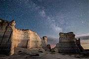 Night view with Milky Way
See also
Other geological formations in Kansas:
References
- S. W. Williston, The Niobrara Cretaceous of Western Kansas, Transactions of the Annual Meetings of the Kansas Academy of Science, Vol. 13, (1891 - 1892), pp. 107–111.