Moreland Street Historic District
|
Moreland Street Historic District | |
|
Moreland Street and Blue Hill Avenue | |
  | |
| Location | Boston, Massachusetts |
|---|---|
| Coordinates | 42°19′25″N 71°4′48″W / 42.32361°N 71.08000°WCoordinates: 42°19′25″N 71°4′48″W / 42.32361°N 71.08000°W |
| Area | 63 acres (25 ha) |
| Built | 1850 |
| Architect | Bradlee,N.J.; Besarick,J.H.,et al. |
| Architectural style | Second Empire, Italianate, Queen Anne |
| NRHP Reference # | [1] |
| Added to NRHP | March 29, 1984 |
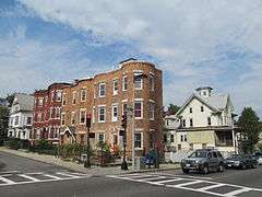
The Moreland Street Historic District is a historic district roughly bounded by Kearsarge, Blue Hill Avenues, and Warren, Waverly, and Winthrop Streets in the Roxbury neighborhood of Boston, Massachusetts. It encompasses 63 acres (25 ha) of predominantly residential urban streetscape, which was developed between about 1840 and 1920. Housing types represent a cross-section of architectural styles from the period, including Second Empire, Italianate, and Queen Anne style. It is a fairly well-preserved grouping in an area where many sections have been negatively affected by urban blight and redevelopment. One notable house is at 130 Warren Street: it is the only house in the district built out of Roxbury puddingstone.[2]
The district was listed on the National Register of Historic Places in 1984.[1]
See also
References
- 1 2 National Park Service (2008-04-15). "National Register Information System". National Register of Historic Places. National Park Service.
- ↑ "NRHP nomination for Moreland Street Historic District". Commonwealth of Massachusetts. Retrieved 2014-06-18.
| Topics |  | ||||||||||||||||||||||||||||||
|---|---|---|---|---|---|---|---|---|---|---|---|---|---|---|---|---|---|---|---|---|---|---|---|---|---|---|---|---|---|---|---|
| Lists by county | |||||||||||||||||||||||||||||||
| Lists by city |
| ||||||||||||||||||||||||||||||
| Other lists | |||||||||||||||||||||||||||||||
| |||||||||||||||||||||||||||||||