Motukawao Islands
| Maori: Motukawao | |
|---|---|
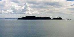 Motukawao Islands and Hauraki Gulf from Amodeo Bay, near Colville. | |
| Geography | |
| Location | Waikato Region |
| Coordinates | 36°41′24″S 175°24′00″E / 36.690°S 175.400°E |
| Administration | |
| Demographics | |
| Population | 0 |
The Motukawao Islands are the northernmost of several small groups of islands that lie in the Hauraki Gulf off the west coast of the Coromandel Peninsula, New Zealand. They lie some 5 kilometres (3.1 mi) to the southwest of Colville, and are uninhabited. The largest of the islands are Motuwi and Ngamotukaraka Islands; others include Moturua and Motukaramarama Islands.
Coordinates: 36°41′24″S 175°24′00″E / 36.690°S 175.400°E
See also
References
External links
This article is issued from Wikipedia - version of the 1/25/2015. The text is available under the Creative Commons Attribution/Share Alike but additional terms may apply for the media files.