Mount Airy Township, Surry County, North Carolina
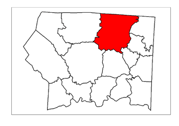
Mount Airy Township is one of fifteen townships in Surry County, North Carolina. The township had a population of 24,828 according to the 2000 census.
Geographically, Mount Airy Township occupies 43.1 square miles (112 km2) in northern Surry County, with its northern border being with the state of Virginia. Mount Airy Township is the most populated township of Surry County, accounting for nearly 35% of the total county population. There are multiple unincorporated communities located here, including Bannertown, Boones Hill, Flat Rock, Franklin, Holly Springs, Salem, Sheltontown, Slate Mountain, Toast, White Plains, and White Sulphur Springs.
The township surrounds the city of Mount Airy and includes the census-designated places of Flat Rock, Toast, and White Plains. U.S. Highway 52 bypasses the city to the west and hosts much of the area's retail activity, including hotels, restaurants, and the Mayberry Mall. Interstate 74 passes through the south side of Mount Airy Township, which is in the Winston-Salem/Greensboro Combined MSA.

Municipalities and communities of Surry County, North Carolina, United States | ||
|---|---|---|
| City | 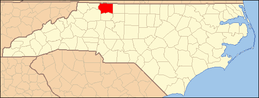 | |
| Towns | ||
| CDPs | ||
| Unincorporated communities |
| |
| Footnotes | ‡This populated place also has portions in an adjacent county or counties | |
Coordinates: 36°31′09″N 80°36′38″W / 36.5192688°N 80.610489°W