Mount Edgecumbe (Alaska)
| Mount Edgecumbe | |
|---|---|
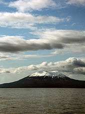
 Mount Edgecumbe in December 2004. | |
| Highest point | |
| Elevation | 3,201 ft (976 m) |
| Prominence | 3,201 ft (976 m) |
| Coordinates | 57°03′05″N 135°45′31″W / 57.05139°N 135.75861°WCoordinates: 57°03′05″N 135°45′31″W / 57.05139°N 135.75861°W |
| Geography | |
| Location | Kruzof Island, Sitka City and Borough, Alaska, U.S. |
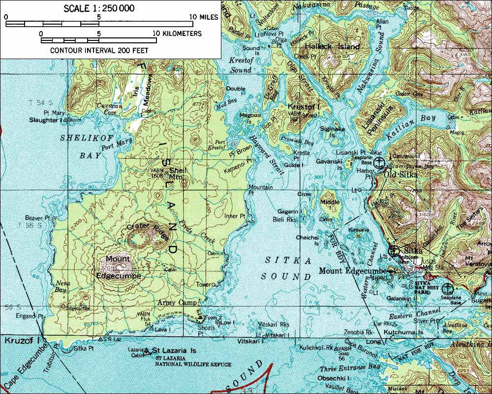
| Topo map | USGS Sitka A-6 |
| Geology | |
| Age of rock | < 600,000 yr |
| Mountain type | Dacite stratovolcano |
| Last eruption | 2220 BCE ± 100 years |
| Climbing | |
| First ascent | 1805 by Urey Lisianski |
| Easiest route | Hike |
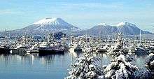
Mount Edgecumbe is a dormant volcano located at the southern end of Kruzof Island, Alaska. The volcano is about 16 km (10 miles) east of the Queen Charlotte Fault that separates the North American and Pacific Plates, and is the highest point in the Mount Edgecumbe volcanic field, an area of about 260 km² (162 sq miles) on Kruzov Island that also includes Crater Ridge and Shell Mountain.[1]
Name
The indigenous Tlingit people considered the mountain to be sacred.[2] In the Tlingit language, the mountain is called L’ux, which means "to flash" or "blinking," purportedly because the Tlingit people first discovered it while it was smoking or erupting.[2]
On 16 August 1775, Spanish explorer Juan de la Bodega named the mountain Montaña de San Jacinto to honor Saint Hyacinth, whose feast day is celebrated on 17 August.[3] Captain James Cook passed the mountain on 2 May 1778 during his third voyage and named it Mount Edgecumbe, presumably after a hill overlooking Plymouth Harbor, England, or possibly for George, Earl of Edgcumbe.[4] Explorer George Vancouver later adopted the name chosen by Cook, and it came into popular usage.[5]
Ascent
The first recorded ascent was made in July 1805 by Captain Urey Lisianski of the Imperial Russian Navy.[5] In the 1930s a trail to the top of the mountain was made by the Civilian Conservation Corps as part of a New Deal program to ease the Great Depression.[6]
The Mt. Edgecumbe Trail is roughly 11 km (7 miles), ascending through taiga and muskeg before becoming steep and ending in a barren landscape of snow and red volcanic ash above the treeline, at about 2,000 feet, with sign-posts directing hikers toward the crater rim.[6] A three-sided cabin built by the Conservation Corps lies about four miles up trail.[6] The trail can be muddy and wet in places, the last three miles are a steep climb, and bears may be present.[7] The difficulty of the trail is listed as "moderate."[6]
Eruptions
Eruption hoax
On April 1, 1974, a local prankster named Oliver "Porky" Bickar ignited hundreds of old tires in the crater, which he had flown in for an April Fools' Day joke.[9] The dark smoke rising from the crater convinced nearby residents of Sitka, Alaska that the volcano was erupting. The hoax was soon revealed, as around the rim of the volcano, "April Fool" was spray-painted in 50 ft letters. The Guardian reports that Bickar had been planning the prank for four years, and lists it among the ten best Aprils Fools hoaxes of all time.[10]
See also
References
- ↑ "Edgecumbe Volcano". Retrieved 5 October 2016.
- 1 2 Bunten, Alexis C. (2015). So, How Long Have You Been Native?: Life As an Alaska Native Tour Guide. University of Nebraska Press. p. 89.
- ↑ Orth, Donald J. (1967). Dictionary of Alaska Place Names, Geological Survey, Professional Paper 567. Washington: United States Government Printing Office.
- ↑ Wagner, Henry (1937). The Cartography of the Northwest Coast of America to the Year 1800. Berkeley: University of California Press. p. 385.
- 1 2 "Alaskan Places named by Cook: Part 1". Retrieved 5 October 2016.
- 1 2 3 4 "Mt. Edgecumbe Trail". alaska.org. Retrieved 5 October 2016.
- ↑ "Mount Edgecumbe Trail". http://www.sitkatrailworks.org/. Sitka Trail Works Inc. Retrieved 10 February 2015. External link in
|website=(help) - ↑ "Mount Edgecumbe". Global Volcanism Program. Smithsonian Institution.
- ↑ "The Top 100 April Fool's Day Hoaxes of All Time". Retrieved 5 October 2016.
- ↑ Lamont, Tom (1 April 2012). "The 10 best April fools". The Guardian. London. Retrieved 2012-04-01.
External links
- Topographic map of Mount Edgecumbe (1:250,000 scale) from USGS Sitka and Port Alexander
- Alaska Volcano Observatory