Mount Edwards (Queensland)
| Mount Edwards | |
|---|---|
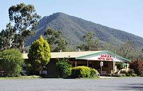 Mount Edwards behind the Aratula Hotel | |
| Highest point | |
| Elevation | 634 m (2,080 ft) [1] |
| Coordinates | 28°00′59″S 152°33′00″E / 28.01639°S 152.55000°ECoordinates: 28°00′59″S 152°33′00″E / 28.01639°S 152.55000°E |
| Geography | |
 Mount Edwards | |
| Parent range | Moogerah Peaks |
| Geology | |
| Age of rock | 23 million years [2] |
| Mountain type | Volcanic plug |
| Climbing | |
| Easiest route | Walking track |
Mount Edwards is a mountain in South East Queensland, Australia. The mountain rises 634 metres (2,080 ft) above sea level and is part of the Moogerah Peaks National Park. It lies approximately 100 km south west of Brisbane approximately 17km(10.5mi) from the town of Boonah. The mountain is the closest of the Moogerah Peaks to the Cunningham Highway and is 9 km south of Aratula. Other prominent peaks in this Scenic Rim group of mountains includes Mount French, Mount Moon and Mount Greville.
Explorer John Oxley named the mountain Mount Banister in 1824.[3] Later renamed in 1828 by Alan Cunningham after Lieutenant George Edwards.[3]
The summit is accessed by walking track that starts across the Moogerah Dam wall.[2] The 1.1 km walk to the top affords views across Fassifern Valley.
Between Mount Edwards and Little Mount Edwards (363 m) to the east, is Reynolds Creek which flows through a steeply sloped gorge.[2]
See also
References
- ↑ "About Moogerah Peaks". Department of Environment and Resource Management. Queensland Government. Retrieved 2010-11-20.
- 1 2 3 Moogerah Peaks National Parks: Visitor Information[brochure]. Queensland Parks and Wildlife Service. 1992. Environmental Protection Agency (Queensland).
- 1 2 "Moogerah Peaks National Park — Nature, culture and history". The State of Queensland. Retrieved 2009-08-07.