Mount Erebus
| Mount Erebus | |
|---|---|
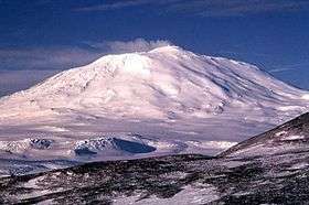 Mount Erebus, 1972 | |
| Highest point | |
| Elevation | 3,794 m (12,448 ft) [1] |
| Prominence |
3,794 m (12,448 ft) [1] Ranked 34th |
| Isolation | 121 kilometres (75 mi) |
| Listing | Ultra |
| Coordinates | 77°31′47″S 167°09′12″E / 77.52972°S 167.15333°ECoordinates: 77°31′47″S 167°09′12″E / 77.52972°S 167.15333°E [2] |
| Geography | |
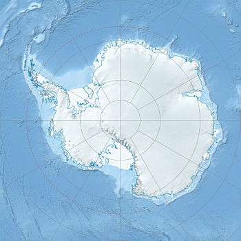 Mount Erebus Mount Erebus in Antarctica | |
| Location | Ross Island, Antarctica |
| Topo map | Ross Island |
| Geology | |
| Age of rock | 1.3 million years |
| Mountain type | Stratovolcano (composite cone) |
| Last eruption | 1972 to present |
| Climbing | |
| First ascent | 1908 by Edgeworth David and party[3] |
| Easiest route | Basic snow & ice climb |
Mount Erebus (pronunciation: /ˈɛrᵻbəs/) is the second-highest volcano in Antarctica (after Mount Sidley) and the southernmost active volcano on earth. It is the sixth highest ultra mountain on an island.[1] With a summit elevation of 3,794 metres (12,448 ft), it is located on Ross Island, which is also home to three inactive volcanoes, Mount Terror, Mount Bird, and Mount Terra Nova.
The volcano has been active since c. 1.3 million years ago[4] and is the site of the Mount Erebus Volcano Observatory run by the New Mexico Institute of Mining and Technology.[5]
Geology and volcanology
Mount Erebus is currently the most active volcano in Antarctica and is the current eruptive zone of the Erebus hotspot. The summit contains a persistent convecting phonolitic lava lake, one of five long-lasting lava lakes on Earth. Characteristic eruptive activity consists of Strombolian eruptions from the lava lake or from one of several subsidiary vents, all within the volcano's inner crater.[6][7] The volcano is scientifically remarkable in that its relatively low-level and unusually persistent eruptive activity enables long-term volcanological study of a Strombolian eruptive system very close (hundreds of metres) to the active vents, a characteristic shared with only a few volcanoes on Earth, such as Stromboli in Italy. Scientific study of the volcano is also facilitated by their proximity to McMurdo Station (U.S.) and Scott Base (New Zealand), both sited on Ross Island approximately thirty-five kilometres away.
Mount Erebus is classified as a polygenetic stratovolcano. The bottom half of the volcano is a shield and the top half is a stratocone. The composition of the current eruptive products of Erebus is anorthoclase-porphyritic tephritic phonolite and phonolite, which are the bulk of exposed lava flow on the volcano. The oldest eruptive products consist of relatively undifferentiated and non-viscous basanite lavas that form the low broad platform shield of Erebus. Slightly younger basanite and phonotephrite lavas crop out on Fang Ridge—an eroded remnant of an early Erebus volcano—and at other isolated locations on the flanks of Erebus. Erebus is the world's only presently erupting phonolite volcano.[8]
Lava flows of more viscous phonotephrite and trachyte erupted after the basanite. The upper slopes of Mount Erebus are dominated by steeply dipping (~30°) tephritic phonolite lava flows with large scale flow levees. A conspicuous break in slope at approximately 3,200 metres calls attention to a summit plateau representing a caldera. The summit caldera was created by an explosive VEI-6 eruption that occurred 18,000 ± 7,000 years ago.[9] It is filled with small volume tephritic phonolite and phonolite lava flows. In the center of the summit caldera is a small steep-sided cone composed primarily of decomposed lava bombs and a large deposit of anorthoclase crystals known as Erebus crystals. The active lava lake in this summit cone undergoes continuous degassing.
Researchers spent more than three months during the 2007–08 field season installing an unusually dense array of seismometers around Mount Erebus to listen to waves of energy generated by small, controlled blasts from explosives they buried along its flanks and perimeter and to record scattered seismic signals generated by lava lake eruptions and local ice quakes. By studying the refracted and scattered seismic waves, the scientists produced an image of the uppermost (top few km) of the volcano to understand the geometry of its "plumbing" and how the magma rises to the lava lake. [10][11] These results demonstrated a complex upper-volcano conduit system with appreciable upper-volcano magma storage to the northwest of the lava lake at depths hundreds of meters below the surface.
Ice fumaroles
Mt. Erebus is notable for its numerous ice fumaroles – ice towers that form around gases that escape from vents in the surface.[12] The ice caves associated with the fumaroles are dark, in polar alpine environments starved in organics and with oxygenated hydrothermal circulation in highly reducing host rock. The life is sparse, mainly bacteria and fungi. This makes it of special interest for studying oligotrophs – organisms that can survive on minimal amounts of resources.
It is thought that ice caves may exist on Mars – ice preserved under the surface in cave systems protected from the surface conditions.[13]
The caves on Erebus are of especial interest for astrobiology as most surface caves are influenced by human activities, or by organics from the surface brought in by animals (e.g. bats) or ground water. The caves at Erebus are high altitude, yet accessible for study. There is almost no chance of photosynthetic based organics, or of animals in a food chain based on photosynthetic life, and no overlying soil to wash down into them.
They are dynamical systems that collapse and rebuild, but persist over decades. The air inside the caves has 80% to 100% humidity, and up to 3% CO2, and some CO and H2, but almost no CH4 or H2S. Many of them are completely dark, so can't support photosynthesis. Organics can only come from the atmosphere, or from ice algae that grow on the surface in summer, which may eventually find their way into the caves through burial and melting. As a result, most micro-organisms there are chemolithoautotrophic i.e. microbes that get all of their energy from chemical reactions with the rocks, and that don't depend on any other lifeforms to survive. The organisms survive using CO2 fixation and it's hypothesized that some use CO oxidization for the metabolism. The main types of microbe found there are Chloroflexi and Acidobacteria.[14][15]
History
Discovery and naming
Mount Erebus was discovered on January 27, 1841 (and observed to be in eruption)[16] by polar explorer Sir James Clark Ross who named it and its companion, Mount Terror, after his ships, Erebus and Terror (which were later used by Sir John Franklin on his disastrous Arctic expedition). Present with Ross on the Erebus was the young Joseph Hooker, future president of the Royal Society and close friend of Charles Darwin. Erebus was a primordial Greek god of darkness, the son of Chaos.[17]
Historic sites
The mountain was surveyed in December 1912 by a science party from Scott’s Terra Nova Expedition who also collected geological samples. Two of the camp sites they used have been recognised for their historic significance:
- Upper “Summit Camp” site (HSM 89) consists of part of a circle of rocks, which were probably used to weight the tent valances.
- Lower “Camp E” site (HSM 90) consists of a slightly elevated area of gravel as well as some aligned rocks, which may have been used to weight the tent valances.
They have been designated Historic Sites or Monuments following a proposal by the United Kingdom, New Zealand and the United States to the Antarctic Treaty Consultative Meeting.[18]
Climbing
Mount Erebus' summit crater rim was first achieved by members of Sir Ernest Shackleton's party; Professor Edgeworth David, Sir Douglas Mawson, Dr Alister Mackay, Jameson Adams, Dr Eric Marshall and Phillip Brocklehurst (who did not reach the summit), in 1908. Its first known solo ascent and the first winter ascent was accomplished by British mountaineer Roger Mear on 7 June 1985, a member of the "In the Footsteps of Scott" expedition.[19] On January 19–20, 1991, Charles J. Blackmer, an iron-worker for many years at McMurdo Station and the South Pole, accomplished a solo ascent in approximately seventeen hours completely unassisted via snow mobile and on foot.[20][21]
Robotic exploration
In 1992 the inside of the volcano was explored by Dante I, an eight legged tethered robotic explorer.[22] Dante was designed to acquire gas samples from the magma lake inside the inner crater of Mount Erebus in order to understand the chemistry better through the use of the on-board gas chromatograph as well as measuring the temperature inside the volcano and the radioactivity of the materials present in such volcanoes. Dante successfully scaled a significant portion of the crater before technical difficulties emerged with the fibre-optic cable used for communications between the walker and base station. Unfortunately, Dante I had not yet reached the bottom of the crater and so no data of volcanic significance was recorded. However, the expedition proved to be highly successful in terms of robotic and computer science, and was possibly the first ever expedition by a robotic platform to Antarctica.
Air New Zealand Flight 901
Air New Zealand Flight 901 was a scheduled sightseeing service from Auckland Airport in New Zealand to Antarctica and return with a scheduled stop at Christchurch Airport to refuel before returning to Auckland.[23] The Air New Zealand flyover service, for the purposes of Antarctic sightseeing, was operated with McDonnell Douglas DC-10-30 aircraft and began in February 1977. The flight crashed into Mount Erebus in whiteout conditions on November 28, 1979, killing all 257 people aboard. Further investigation of the crash shows an Air New Zealand navigational error and a cover-up that resulted in about $100 million in lawsuits. Air New Zealand discontinued its flyovers of Antarctica. Its final flight was in February 17, 1980. During the Antarctic summer, snow melt on the flanks of Mount Erebus continually reveals debris from the crash; it is visible from the air.[23]
Image gallery
-
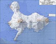
Topographic map of Ross Island (1:250,000 scale) from United States Geological Survey
-
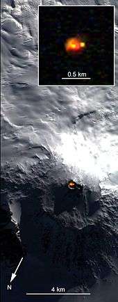
Satellite picture of Mount Erebus showing glow from its persistent lava lake
-
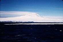
Mount Erebus in December 1955
See also
- Erebus Glacier
- Erebus Ice Tongue
- List of islands by highest point
- List of volcanoes in Antarctica
- Lower Erebus Hut – home of MEVO
- Nimrod Expedition – first ascent of Mount Erebus
- Volcanic Seven Summits#Volcanic Seven Second Summits
- Air New Zealand Flight 901
References
- 1 2 3 "Mount Erebus". Global Volcanism Program. Smithsonian Institution. Retrieved 2008-12-29.
- ↑ "Mount Erebus". Geographic Names Information System. United States Geological Survey. Retrieved 2011-07-30.
- ↑ "Antarctic explorers". Australian Antarctic Division. Retrieved 2008-12-29.
- ↑ "Mt. Erebus". Mt. Erebus Volcano Observatory (MEVO). Retrieved January 11, 2015.
- ↑ "Mount Erebus Volcano Observatory". New Mexico Tech. Retrieved 2008-12-29.
- ↑ Kyle, P. R., ed. (1994). Volcanological and Environmental Studies of Mount Erebus, Antarctica. Antarctic Research Series. Washington DC: American Geophysical Union. ISBN 0-87590-875-6.
- ↑ Aster, R.; Mah, S.; Kyle, P.; McIntosh, W.; Dunbar, N.; Johnson, J. (2003). "Very long period oscillations of Mount Erebus volcano". J. Geophys. Res. 108: 2522. doi:10.1029/2002JB002101.
- ↑ Burgisser, Alain; Oppenheimer, Clive, Alletti, Marina; Kyle, Phillip R.; Scaillet, Bruno; Carroll, Michael R. (November 2012). "Backward Tracking of gas chemistry measurements at Erebus volcano". Geochemistry Geophysics Geosystems. 13 (11): 24. doi:10.1029/2012GC004243.
- ↑ http://www.bgs.ac.uk/vogripa/searchVOGRIPA.cfc?method=detail&id=2421
- ↑ "Plumbing Erebus: Scientists use seismic technique to map interior of Antarctic volcano".
- ↑ Zandomeneghi, D.; Aster, R.; Kyle, P.; Barclay, A.; Chaput, J.; Knox, H. (2013). "Internal structure of Erebus volcano, Antarctica imaged by high-resolution active-source seismic tomography and coda interferometry". J. Geophysical Research. 118 (3): 1067–1078. doi:10.1002/jgrb.50073.
- ↑ For photographs of ice fumaroles, see Ice Towers Mount Everest Volcano Observatory
- ↑ Williams, K.E.; McKay, Christopher P.; Toon, O.B.; Head, James W. (2010). "Do ice caves exist on Mars?" (PDF). Icarus. 209 (2): 358–368. doi:10.1016/j.icarus.2010.03.039. ISSN 0019-1035.
- ↑ Tebo, Bradley M.; Davis, Richard E.; Anitori, Roberto P.; Connell, Laurie B.; Schiffman, Peter; Staudigel, Hubert (2015). "Microbial communities in dark oligotrophic volcanic ice cave ecosystems of Mt. Erebus, Antarctica". Frontiers in Microbiology. 6. doi:10.3389/fmicb.2015.00179. ISSN 1664-302X.
- ↑ Wall, Mike. "Antarctic Cave Microbes Shed Light on Life's Diversity". Livescience.
- ↑ Ross, Voyage to the Southern Seas, vol. i, pp. 216–8.
- ↑ Hesiod, Theogony 116–124.
- ↑ "List of Historic Sites and Monuments approved by the ATCM (2013)" (PDF). Antarctic Treaty Secretariat. 2013. Retrieved 2014-01-09.
- ↑ Mear, Roger and Robert Swan, In the Footsteps of Scott, pp. 95–104.
- ↑ Wheeler, Sara. Terra Incognita.
- ↑ Johnson, Nicholas. Big Dead Place.
- ↑ Wettergreen, David; Chuck Thorpe; William Whittaker (1993). "Exploring Mount Erebus by Walking Robot". International Conference of Intelligent Autonomous Systems: 72–81.
- 1 2 Holmes P., Daughters of Erebus, Hachette New Zealand Ltd (2011), p. 31
- General
- LeMasurier, W. E.; Thomson, J. W., eds. (1990). Volcanoes of the Antarctic Plate and Southern Oceans. American Geophysical Union. ISBN 0-87590-172-7.
- The Mount Erebus Volcano Observatory (includes live camera images of the volcano's lava lake, video clips of eruptions, and other information)
External links
| Wikimedia Commons has media related to Mount Erebus. |
- A picture from space of the lava lake at the summit of Mount Erebus
- Erebus glacier tongue
- A panoramic view from the summit of Mount Erebus
- Footage of Mount Erebus erupting in 2005
![]() Mount Erebus travel guide from Wikivoyage
Mount Erebus travel guide from Wikivoyage