Mount Formidable
| Mount Formidable | |
|---|---|
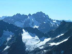 Mount Formidable as seen above the Cache Col Glacier | |
| Highest point | |
| Elevation | 8,325 feet (2,537 m) [1]:265 –267 |
| Prominence | 1,885 feet (575 m) [2] |
| Parent peak | Overdrive Tower |
| Coordinates | 48°24′59″N 121°4′2″W / 48.41639°N 121.06722°WCoordinates: 48°24′59″N 121°4′2″W / 48.41639°N 121.06722°W [2] |
| Geography | |
 Mount Formidable The location of Mount Formidable within Washington state | |
| Location | Skagit County, Washington, United States |
| Parent range | North Cascades |
| Topo map | USGS Cascade Pass |
| Geology | |
| Age of rock | Triassic |
| Mountain type | Fold |
| Climbing | |
| First ascent |
Calder T. Bressler Ralph W. Clough Bill Cox Tom Myers |
| Easiest route | Class III |
Mount Formidable is a mountain in the North Cascades of Skagit County, in Washington state.[3] Its first ascent was undertaken by members of the original Ptarmigan Traverse, and the peak is a popular climb for parties on the traverse.[1]:265 –267 It was named by early mountaineer Herman Ulrichs in 1935 because of the rugged appearance of its north face.[1]:265 –267 The peak is usually accessed from Cascade Pass via the Ptarmigan Traverse.
Geography and climate
Mount Formidable is located on a spur ridge about half a mile west of the Cascade crest, between Cascade Pass and Dome Peak, and about a mile west of Spider Mountain.[3] It is within the Marine west coast climatic zone, and experiences heavy snowfall as a result. The surrounding area is part of the Pacific temperate rainforest ecoregion, and lower elevations are densely vegetated.[1]:214 -217 The Middle Cascade Glacier, which drains into the Skagit River via the Cascade River,[4] is on the north side of the mountain.[1]:265 -267
Geology
The North Cascades are composed of terranes, or scattered, unrelated rock groups of various ages.[5] More specifically, the immediate area surrounding Mount Formidable (i.e., within ten miles), is mainly composed of granitic rocks that are Mesozoic in age, and schist that dates from the late paleozoic.[6] Mount Formidable itself is likely composed of originally igneous rocks that formed in the Triassic and were metamorphorphized in the Late Cretaceous.[7]
Climbing
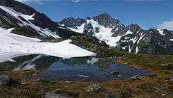
Mount Formidable is usually accessed via the Ptarmigan Traverse, which begins at Cascade Pass.[1]:265 –267 Climbers ascend from Cascade Pass to Cache Col via the Cache Col Glacier, then traverse toward Kool-Aid Lake, a small, alpine lake that drains into the Middle Fork of the Cascade River. Climbers then typically traverse south towards the Middle Cascade Glacier via the Red Ledges, then around the south side of the mountain to the summit.[8] There are, however, alternative routes, most of which involve ascending from the Middle Cascade Glacier.[1]:265 –267
References
- 1 2 3 4 5 6 7 Beckey, Fred (2003). Fulsaas, Kris; Clifton-Thornton, Christine, eds. Climbing and High Routes: Stevens Pass to Rain Pass — Fred Beckey — Google Books. Cascade Alpine Guide: Climbing and High Routes: Stevens Pass to Rainy Pass (3rd ed.). Seattle, Washington: The Mountaineers Books. ISBN 9781594851551. Retrieved August 25, 2013.
- 1 2 "Mount Formdable". Peakbagger.com. 2013. Retrieved August 26, 2013.
- 1 2 CASCADE PASS, WASH — NO 80 (Map). 1: 69500. 15 minute series. Green Trails. 1989 [First published 1977]. Retrieved August 26, 2013.
- ↑ "Cascade River". Geographic Names Information System. United States Geological Survey.
- ↑ Lasmanis, Raymond. The geology of Washington: Rocks and Minerals. 1991. (cited in "Geology of Washington — Northern Cascades". Washington State Department of Natural Resources. 2013.) Retrieved August 28, 2013.
- ↑ Cater, Fred W. (1982). "INTRUSIVE ROCKS OF THE HOLDEN AND LUCERNE QUADRANGLES, WASHINGTON—THE RELATION OF DEPTH ZONES, COMPOSITION, TEXTURES, AND EMPLACEMENT OF PLUTONS". United States Geological Survey. Retrieved October 18, 2013.
- ↑ Carter, F.W. (1982). "Intrusive Rocks of the Holden and Lucerne Quadrangles, Washington" (PDF): 9 -23. Retrieved August 28, 2013. (cited in Beckey 2003)
- ↑ Goldman, Peggy (2004). Washington's Highest Mountains: Basic Alpine and Glacier Routes — Peggy Goldman — Google Books. Washington's Highest Mountains: Basic Alpine and Glacier Routes. Birmingham, Alabama: Wilderness Press. p. 84 –87. ISBN 9780899976082. Retrieved August 27, 2013.
External links
 Media related to Mount Formidable at Wikimedia Commons
- Mount Formidable on Peakware.com
- Mount Formidable on Summitpost.org