Mount Nanlaud
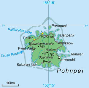
Map of Pohnpei Island showing Nanlaud
Mount Nanlaud is the highest point of the Micronesian island of Pohnpei at 2,533 feet (772 m),[1][2] although GeoNames claims 2,566 feet (782 m).[3] It is located in the southern part of the island in the northeastern corner of Kitti Municipality near the borders with Nett and Madolenihmw municipalities, and belongs administratively to the Federated States of Micronesia. Nanlaud is the second highest mountain in Micronesia after Agrihan in the northern Mariana Islands, which has a highest point of 3,165 feet (965 m).[2]
References
- ↑ Guam & Micronesia Glimpses. Sanchez Publishing House. 1990. p. 52. Retrieved 12 May 2013.
- 1 2 Karolle, Bruce G. (1993). Atlas of Micronesia. Bess PressInc. p. 103. ISBN 978-1-880188-50-7. Retrieved 12 May 2013.
- ↑ "Mount Nanlaud". GeoNames. Retrieved 12 May 2013.
Coordinates: 6°52′32″N 158°13′40″E / 6.87556°N 158.22778°E
This article is issued from Wikipedia - version of the 10/19/2016. The text is available under the Creative Commons Attribution/Share Alike but additional terms may apply for the media files.