Mount Roland Conservation Area
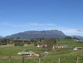
Mount Roland from the lookout at Sheffield.
Mount Roland is a Conservation area in the north west coast region of Tasmania. [1]
It is near the town of Sheffield. It rises to 1234 metres and there are a number of well-marked bushwalks suitable for a day of pleasant exercise. There are long established walking tracks from both Claude Road and Gowrie Park to the summit.[2][3][4]
A Mount Roland cable car has been proposed for the mountain on several occasions.[5] The local community remains divided over the suitability or desirability of a cable car. [6]
Notes
- ↑ University of Tasmania. Institute for Regional Development; Mount Roland Steering Committee (Tas.) (2011), Mount Roland developing a destination, University of Tasmania, retrieved 12 July 2012
- ↑ "ON MOUNT ROLAND.". Examiner (Launceston, Tas. : 1900 - 1954). Launceston, Tas.: National Library of Australia. 11 January 1910. p. 4 Edition: DAILY. Retrieved 12 July 2012.
- ↑ Tasmania. Dept. of Parks, Wildlife and Heritage (1990), Mount Roland day walk map, Tasmap, retrieved 12 July 2012
- ↑ Mount Roland day walk map, Tasmap, 1986, retrieved 12 July 2012
- ↑ "Cable car tourism push for Sheffield's Mt Roland". The Mercury. 27 April 2014. Retrieved 23 January 2015.
- ↑ http://www.utas.edu.au/__data/assets/pdf_file/0012/221223/MOUNT_ROLAND_REPORT-FINAL-06072011.pdf
Coordinates: 41°27′S 146°15′E / 41.450°S 146.250°E
This article is issued from Wikipedia - version of the 6/4/2016. The text is available under the Creative Commons Attribution/Share Alike but additional terms may apply for the media files.