Mount Shinn
| Mount Shinn | |
|---|---|
.jpg) Mount Shinn from North East | |
| Highest point | |
| Elevation | 4,661 m (15,292 ft) [1] |
| Prominence | 961 m (3,153 ft) [1] |
| Listing | |
| Coordinates | 78°27′49″S 85°43′29″W / 78.46361°S 85.72472°WCoordinates: 78°27′49″S 85°43′29″W / 78.46361°S 85.72472°W [1] |
| Geography | |
 Mount Shinn Location in Antarctica | |
| Location | Antarctica |
| Parent range | Sentinel Range, Ellsworth Mountains |
| Climbing | |
| First ascent | 21 December 1966 by Barry Corbet, Charles Hollister, Sam Silverstein and Richard Wahlstrom |
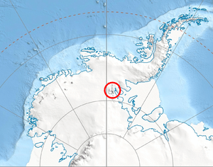
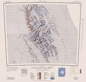
Mount Shinn is a mountain 4,661 meters in elevation, standing 6 km (4 miles) southeast of Mount Tyree in the Sentinel Range, Ellsworth Mountains. It surmounts Ramorino Glacier to the north, upper Crosswell Glacier to the northeast, Goodge Col to the southeast, and Branscomb Glacier to the south-southwest.
The peak was discovered on IGY reconnaissance flights in January 1958, and named by the Advisory Committee on Antarctic Names (US-ACAN) for Lieutenant Commander Conrad S. (Gus) Shinn, U.S. Navy, a pilot on some of these flights. Shinn was pilot of the Navy R4D aircraft carrying Admiral Dufek which, on October 31, 1956, made the first plane landing at the geographic South Pole. It had been thought to be over 4800m high, but was re-measured in 2001 by Damien Gildea and Rodrigo Fica of the Omega Foundation, using a Trimble 5700 GPS receiver and the Australian government's AUSPOS processing system.
Maps
- Vinson Massif. Scale 1:250 000 topographic map. Reston, Virginia: US Geological Survey, 1988.
- Antarctic Digital Database (ADD). Scale 1:250000 topographic map of Antarctica. Scientific Committee on Antarctic Research (SCAR), 1993–2016.
References
- 1 2 3 "Mount Shinn, Antarctica". Peakbagger.com. 1 November 2004. Retrieved 2013-12-29.
![]() This article incorporates public domain material from the United States Geological Survey document "Mount Shinn" (content from the Geographic Names Information System).
This article incorporates public domain material from the United States Geological Survey document "Mount Shinn" (content from the Geographic Names Information System).