Mount Sirung
| Mount Sirung | |
|---|---|
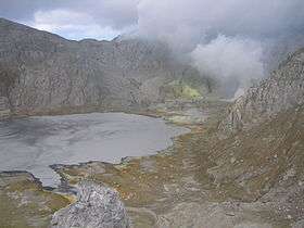 Sirung caldera in 2004 | |
| Highest point | |
| Elevation | 862 m (2,828 ft) |
| Coordinates | 8°31′S 124°08′E / 8.517°S 124.133°E |
| Geography | |
| Location | Pantar Island, East Nusa Tenggara (Indonesia) |
| Geology | |
| Mountain type | Complex volcano |
| Last eruption | July 2015 (ongoing) |
Mount Sirung (Indonesian: Gunung Sirung) is an active volcano complex volcano located on Pantar Island in the Alor archipelago of the eastern Indonesian province of Nusa Tenggara Timor. The crater rim can be reached by an easy hike from the village of Kakamauta. Inside the crater is a large sulphurous crater lake and several active steam vents. The last major eruption occurred 1970, and regular gas and clastic eruptions have occurred since 2004. A small eruption beginning May 12, 2012 triggered an evacuation of an area within a 1.5 km radius of the caldera.

Aerial view
See also
References
External links
- Volcano Live
- Geology of Mt. Sirung (in Indonesian)
- Status Gunung Sirung Turun Jadi Waspada, Suara Mereka, 27 Mei 2012. (In Indonesian)
This article is issued from Wikipedia - version of the 7/9/2015. The text is available under the Creative Commons Attribution/Share Alike but additional terms may apply for the media files.