Mount William (Antarctica)
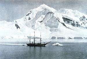
The Belgica anchored at Mount William.
| Mount William | |
|---|---|
| Highest point | |
| Elevation | 1,600 m (5,200 ft) [1] |
| Coordinates | 64°47′S 63°41′W / 64.783°S 63.683°WCoordinates: 64°47′S 63°41′W / 64.783°S 63.683°W [1] |
| Geography | |
| Location | Anvers Island, Antarctica |
Mount William is a prominent snow-covered mountain, 1,600 m, standing 4 miles (6 km) north-northeast of Cape Lancaster, the south extremity of Anvers Island, in the Palmer Archipelago. It was discovered on February 21, 1832, by John Biscoe who believed it to be part of the mainland of Antarctic Peninsula. Named by Biscoe for William IV, then King of the United Kingdom.[1]
References
- 1 2 3 "Mount William". Geographic Names Information System. United States Geological Survey. Retrieved 2007-03-13.
This article is issued from Wikipedia - version of the 11/21/2015. The text is available under the Creative Commons Attribution/Share Alike but additional terms may apply for the media files.