Moyie River Canyon Bridge
| Moyie River Bridge | |
|---|---|
 | |
| Coordinates | 48°43′47″N 116°10′49″W / 48.72972°N 116.18028°W |
| Carries |
2 lanes of |
| Crosses | Moyie River |
| Locale | Moyie Springs, Idaho |
| Official name | Moyie River Canyon Bridge |
| Maintained by | Idaho Transportation Department |
| ID number | 10035 |
| Characteristics | |
| Design | Steel truss - Deck |
| Total length | 1,223 feet (373 m) |
| Height | 424 feet (129 m) |
| History | |
| Opened | 1965 |
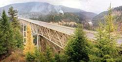
The Moyie River Canyon Bridge is a structural steel truss cantilever bridge that spans the Moyie River in the city of Moyie Springs just east of Bonners Ferry, Idaho. Constructed in 1965, the bridge is on U.S. Route 2 at mile marker 70. The bridge is 1,223-foot (373 m) long and 424 feet (129 m) high, and is a replacement for an obsolete 1923 bridge built downstream from Moyie Dam.[1]
The only higher bridge in Idaho is the 476-foot (145 m) high Perrine Bridge which crosses the Snake River near Twin Falls, Idaho.[1]
See also
-
 Bridges portal
 -
 Idaho portal
External links
Notes
- 1 2 "Moyie Springs". NorthIdaho.org. n.d. Archived from the original on 2016-10-31. Retrieved 2016-10-31.
This article is issued from Wikipedia - version of the 10/31/2016. The text is available under the Creative Commons Attribution/Share Alike but additional terms may apply for the media files.