Mount Manaia

Mount Manaia is a dominant landmark approximately 30 kilometres southeast of Whangarei city on the Whangarei Heads peninsula.
Standing 420 metres, the summit offers outstanding views of the Marsden Point Oil Refinery, Bream Bay and the Hauraki Gulf to the south, Whangarei Harbour to the west and the Poor Knights Islands and Northland coast to the north.
Mt Manaia - along with Mt Lion, Bream Head and the Hen and Chicken Islands, are the scattered remnants of a large, 50 kilometer diameter volcano that erupted with force 20 million years ago during the early miocene period. Its jagged outline is similar to that of its neighbours and other volcanic outcrops in Northland that erupted in a similar period.
Today blanketed by native bush, Manaia's jagged peaks and steep bluffs are protected within a Department of Conservation reserve which features a well-maintained 1½ hour track to the summit.
References
1. Geological Society of New Zealand Annual Conference, 2-5 December 2002
2. Te Ara Encyclopedia of New Zealand
3. Northland Naturally, Mt Manaia web page
Photo gallery
-
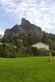
Mt Manaia viewed from Manaia Baptist Camp at Taurikura
-
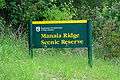
Manaia Ridge Scenic Reserve
-
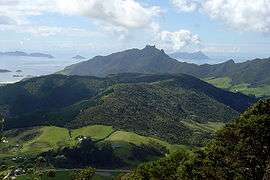
Mt Lion and Taurikura viewed from the flanks of Mt Manaia
-

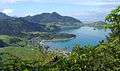
Whangarei Harbour viewed from the summit
-

Looking down at the Marsden Point Oil Refinery from across Whangarei Harbour
-
Bream Head and the Bream Islands viewed from atop the summit
-
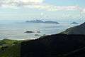
The Bream Islands with Great Barrier Island in the distance viewed from Mt Manaia
External links
Coordinates: 35°49.05′S 174°30.58′E / 35.81750°S 174.50967°E