Mubende
| Uganda | |
|---|---|
 Uganda Location in Uganda | |
| Coordinates: 00°33′27″N 31°23′42″E / 0.55750°N 31.39500°E | |
| Country |
|
| Region | Central Region of Uganda |
| District | Mubende District |
| Elevation | 4,330 ft (1,320 m) |
| Population (2014 Census) | |
| • Total | 46,921[1] |
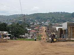
Mubende is a town in the Central Region of Uganda. It is the main municipal, administrative, and commercial center of Mubende District and is the location of the district headquarters.[2]
Location
Mubende is approximately 172 kilometres (107 mi), by road, west of Kampala, the capital of Uganda and its largest city.[3] The coordinates of the town are 0°33'27.0"N, 31°23'42.0"E (Latitude:0.5575; Longitude:31.3950).[4]
Overview
Mubende is home to the Nakayima Shrine, said to hold the spirit of Ndahura, a former Bacwezi king.[5] The site, located about 4 kilometres (2.5 mi) outside of the town's central business district, is marked by the Nakayima tree. Large root buttresses, which form nooks and fissures, lie at the base of the tree.
The shrine is located on top of Mubende Hill, rising 213 metres (699 ft) above the surrounding terrain to a peak of 1,533 metres (5,030 ft) above sea level. The hill has a flat top where an ancient palace once stood.[6] The shrine is visited by people paying homage to the matriarch Nakayima of the Bachwezi, believed to be semi-gods, whose dynasty ruled this region in the period prior to 1,300 AD.[7]
Population
The 2002 national census estimated the population of Mubende to be 16,000. In 2010, the Uganda Bureau of Statistics (UBOS) estimated the population at 21,400. In 2011, UBOS estimated the mid-year population at 22,200.[8] In 2014, the national population census put the population at 46,921.[1]
Points of interest
The following points of interest lie within the town limits or near its edges:
- offices of Mubende Town Council
- Mubende Regional Referral Hospital, a regional referral hospital administered by the Uganda Ministry of Health
- Mubende central market
- a branch of the National Social Security Fund
- headquarters of the Tiger Battalion of the Uganda People's Defence Force, located in the western part of the town
- a portion of Lake Wamala
- source of the River Muzizi, in the hills northwest of the town
- Mubende Campus of Muteesa I Royal University
See also
References
- 1 2 UBOS (27 August 2014). "The Population of The Regions of the Republic of Uganda And All Cities And Towns of More Than 15,000 Inhabitants". Citypopulation.de Quoting Uganda Bureau of Statistics (UBOS). Retrieved 23 February 2015.
- ↑ Mayengo, Godfrey (1 August 2015). "Municipal Status Excites Mubende Residents". Daily Monitor. Kampala. Retrieved 1 August 2015.
- ↑ "Distance Between Kampala And Mubende With Map". Globefeed.com. Retrieved 27 May 2014.
- ↑ Google (2 July 2015). "Location of Mubende at Google Maps" (Map). Google Maps. Google. Retrieved 2 July 2015.
- ↑ SSC (1 August 2014). "Nakayima Tree Uganda". Speedwaysafaris.com (SSC). Retrieved 1 August 2015.
- ↑ GAM (7 January 2016). "Elevation of Mubende Hill". Getamap.net (GAM). Retrieved 7 January 2016.
- ↑ UTB (1 August 2015). "Profile of Mubende Town". Uganda Travel Bureau (UTB). Retrieved 1 August 2015.
- ↑ UBOS. "Estimated Population of Mubende In 2002, 2010 & 2011" (PDF). Uganda Bureau of Statistics (UBOS). Retrieved 27 May 2014.
External links
Capital: Mubende | ||
| Parishes |
| |
| Towns and villages | ||
| Geography |
| |
| Economy |
| |
| Health | ||
| Transport | ||
| Notable landmarks |
| |
| Education | ||
| Notable people | ||
Coordinates: 00°33′27″N 31°23′42″E / 0.55750°N 31.39500°E