Mujibnagar
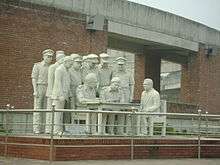
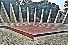
Mujibnagar (Bengali: মুজিবনগর), formerly known as Baidyanathtala (Badhayanathtola) and Bhaberpara, is a town in the Meherpur District of Bangladesh.[2] The Provisional Government of Bangladesh was formed on 10 April 1971 in this town by the leaders of the Awami League, who were leading the guerrilla war for the independence of Bangladesh (then East Pakistan) from Pakistan in 1971.[3] The place was renamed Mujibnagar by the proclamation of independence,[4] in honour of Sheikh Mujibur Rahman, who declared Bangladesh independent.[1] The actual capital of the government while in exile was Calcutta. A memorial complex covering 20.10 acres (8.13 ha) has been built at the site where the ministers of that first government took their oaths.
Throughout the war with the Pakistan Army, the Mujibnagar government would serve as the nominal head of the pro-independence guerrilla militias, mainly the Mukti Bahini. Although the state gained independence that was recognized by other countries only in December 1971, the Mujibnagar government is recognized as the first official government of Bangladesh.[3] The Vice President of Bangladesh, Syed Nazrul Islam, performed the ceremony at Mujibnagar in the role of Acting President, because the President, Sheikh Mujibur Rahman, was detained in Pakistan throughout the war.[3]
References
| Wikimedia Commons has media related to Mujibnagar Memorial. |
- 1 2 Mohammad Faiquzzaman (2012), "Mujibnagar Smriti Saudha", in Sirajul Islam and Ahmed A. Jamal, Banglapedia: National Encyclopedia of Bangladesh (Second ed.), Asiatic Society of Bangladesh
- ↑ Md. Abu Hasan Farooque (2012), "Meherpur District", in Sirajul Islam and Ahmed A. Jamal, Banglapedia: National Encyclopedia of Bangladesh (Second ed.), Asiatic Society of Bangladesh
- 1 2 3 Faiquzzaman, Mohammad (2012). "Mujibnagar Government". In Islam, Sirajul; Jamal, Ahmed A. Banglapedia: National Encyclopedia of Bangladesh (Second ed.). Asiatic Society of Bangladesh.
- ↑ Miah, Sajahan (2012). "Proclamation of Independence". In Islam, Sirajul; Jamal, Ahmed A. Banglapedia: National Encyclopedia of Bangladesh (Second ed.). Asiatic Society of Bangladesh.
External links
- Mujibnagar Memorial Monument Picture
- Mujibnagar Day
- Sheikh Hasina on Mujibnagar Day
- "Mujibnagar Day today", The Daily Star, 5 (669), 17 April 2006
- Mujibnagar
- Zahid Hossain (17 April 2004), "Significance of Mujibnagar Day", The Daily Star, 4 (314)
Coordinates: 23°39′N 88°36′E / 23.650°N 88.600°E
| Bangladesh Liberation War | 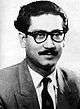 | |
|---|---|---|
| Sheikh Mujib Administration | ||
| Family | ||
| Legacy | ||
| ||