Mulholland Highway
|
Map of Mulholland Drive (orange) and Mulholland Highway (brown) in Los Angeles County | |
| West end |
|
|---|---|
| Major junctions | |
| East end | Mulholland Drive |
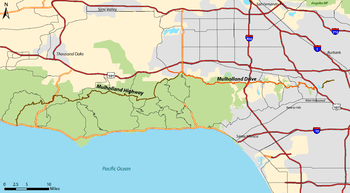

Mulholland Highway is a scenic road in Los Angeles County, California, that runs approximately 50 miles through the western Santa Monica Mountains from near US Route 101 (Ventura Freeway) in Calabasas to Highway 1 (Pacific Coast Highway) near Malibu at Leo Carrillo State Park and the Pacific Ocean coast - at the border of Los Angeles and Ventura Counties.
Mulholland Highway is the western rural portion and with the eastern Mulholland Drive portion, is a scenic route named after William Mulholland and built throughout the 1920s "to take Angelenos from the city to the ocean".
Geography
The name Mulholland Highway applies to a thirty-mile stretch that starts near Louisville High School in Calabasas and extends to its westernmost terminus at Leo Carrillo State Park on the Pacific Coast Highway. Wholly contained within Los Angeles County, the scenic byway was formally opened in 1928. Mulholland zigzags through the Santa Monica Mountains - one of the Southern California Transverse Ranges - from Oxnard all the way to Hollywood. Original major intersections included Topanga Road, Cornell Road, Latigo Canyon Road, and Decker Road.
The route provides access, directly or en route, to many of the regional parks in the Santa Monica Mountains National Recreation Area.
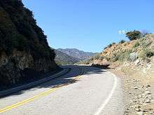
Running east-west along the spine of the Santa Monicas, Mulholland Highway makes its way through the mountains without benefit of tunnels. There are several automobile wrecks and fire-burnt structures that litter the bottoms of the canyons through which Mulholland Highway passes. The native flora of the Santa Monica Mountains are seen throughout the scenic route.
Mulholland Drive
In the early 1970s, five thousand local activists successfully prevented the cement paving of most of the Mulholland Drive stretch. This section, known as "Dirt Mulholland," is only open to cyclists and pedestrians. From Mulholland Bridge east, a cemented Mulholland Drive winds through the affluent Hollywood Hills to Mulholland Drive's easternmost terminus at Cahuenga Boulevard, near Universal Studios. It then becomes Mulholland Highway again as an unpaved footpath to Griffith Park.
See also
External links
| Wikimedia Commons has media related to Mulholland Drive & Highway. |
Coordinates: 34°05′17″N 118°53′44″W / 34.08806°N 118.89556°W