Munith, Michigan
| Munith, Michigan | |
|---|---|
| unincorporated community | |
|
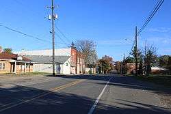
Main Street | |
 Munith, Michigan Location within the state of Michigan | |
| Coordinates: 42°23′26″N 84°15′02″W / 42.39056°N 84.25056°W | |
| Country | United States |
| State | Michigan |
| County | Jackson |
| Township |
Henrietta Waterloo |
| Elevation[1] | 942 ft (287 m) |
| Time zone | Eastern (EST) (UTC-5) |
| • Summer (DST) | EDT (UTC-4) |
| ZIP code | 49259 |
| Area code(s) | 517 |
| FIPS code | 26-56260[2] |
| GNIS feature ID | 633123[1] |
Munith is a small unincorporated community in the northeast of Jackson County in the U.S. state of Michigan. It is situated on M-106 on the boundary between Waterloo Township and Henrietta Township at 42°23′26″N 84°15′02″W / 42.39056°N 84.25056°WCoordinates: 42°23′26″N 84°15′02″W / 42.39056°N 84.25056°W.[1]
The ZIP Code is 49259 and serves portions of both Henrietta [3] and Waterloo [4] townships.[5]
In addition to the post office, there is a township hall, a cemetery, a gas station/hardware store, and zero stoplights. The Munith area is served by the Stockbridge Community Schools district. The community is home to two Christian congregations: Munith United Methodist Church on Main Street [6] and Jeruel Baptist Church on M-106.[7]
References
- 1 2 3 U.S. Geological Survey Geographic Names Information System: Munith, Michigan
- ↑ "American FactFinder". United States Census Bureau. Retrieved 2008-01-31.
- ↑ http://www.henriettatownship.org/
- ↑ http://www.waterlootwpmi.com/
- ↑ 49259 5-Digit ZCTA, 492 3-Digit ZCTA - Reference Map - American FactFinder, United States Census Bureau, 2000 census
- ↑ http://www.westmichiganconference.org/churches/detail/22219
- ↑ http://jeruelbaptist.org/