New York State Route 421
| ||||
|---|---|---|---|---|
|
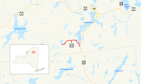
Map of the Tupper Lake area with NY 421 highlighted in red | ||||
| Route information | ||||
| Maintained by NYSDOT | ||||
| Length: | 5.70 mi[1] (9.17 km) | |||
| Existed: | c. 1931[2][3] – present | |||
| Major junctions | ||||
| West end: | Dead end at Horseshoe Lake in Piercefield | |||
| East end: |
| |||
| Location | ||||
| Counties: | St. Lawrence | |||
| Highway system | ||||
| ||||

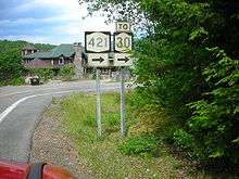
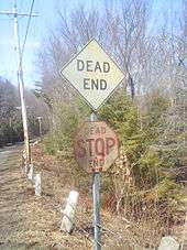
New York State Route 421 (NY 421) is a short state highway located within Adirondack Park in the southeastern corner of St. Lawrence County, New York, in the United States. It is a narrow, two-lane spur route connecting NY 30 to Horseshoe Lake by way of Tupper Lake. A dead end sign is posted immediately off NY 30, the only route with which it intersects. The entire road is located in the town of Piercefield, although that name is not posted on NY 421. The route offers access to several picnic and snowmobile areas.
The eastern portion of NY 421 was built in the 1920s under the terms of a 1923 law authorizing the construction of a highway leading from modern NY 30 north to Warren Point. NY 421 was assigned to the entirety of the north–south highway c. 1931. The roadway connecting Horseshoe Lake to Tupper Lake was built c. 1962 and became part of NY 421 by 1968. NY 421's former routing to Warren Point remained a state highway up through 1999, when a bill permitting the New York State Department of Transportation (NYSDOT) to remove it from the state highway system was signed into law.
Route description
NY 421 begins at a dead end south of the hamlet of Horseshoe in an isolated part of the town of Piercefield. Here, the highway connects to a pair of dirt roads, one of which leads north alongside Horseshoe Lake to Horseshoe. The two-lane route heads eastward from the trails, following the southern shore of Horseshoe Lake while traversing the deep woods of Adirondack Park. At the southeastern end of the lake, NY 421 turns northeastward, crossing a small stream feeding into the lake before curving back toward the east. For the next 2 miles (3.2 km), the road passes through unabated wilderness as it heads toward the western shoreline of Tupper Lake.[4]
At Tupper Lake, the route serves a cluster of recreational buildings at its intersection with Warren Point Road, a private drive leading to Warren Point. Here, NY 421 turns southward, running along the lake shore to nearby Paradise Point Road, which leads east to Paradise Point and the lakeside Veterans' Mountain Camp. After Paradise Point Road, the highway follows a winding, southeasterly course along Tupper Lake, passing little more than dense forests while crossing over the Bog River near its mouth. NY 421 follows the lake to its southern tip, where the route ends at an intersection with NY 30 just west of the St. Lawrence–Franklin county line.[4]
History
In 1923, the New York State Legislature passed a law authorizing the construction of a highway connecting Route 24 (an unsigned legislative route that is now part of NY 30) to the new Veterans' Mountain Camp, an American Legion camp on Tupper Lake. The work was funded through appropriations defined in the law.[5] The highway was completed by 1929[6] and extended from modern NY 30 north to a dead end at Warren Point.[7] In the 1930 renumbering of state highways in New York, hundreds of state-maintained highways that did not yet have a designation were assigned one.[8] The Veterans' Mountain Camp highway was designated as NY 421 by the following year.[2][3]
A highway leading westward from NY 421 southwest of Warren Point to Horseshoe Lake was completed c. 1962.[9][10] It became part of an extended NY 421 by 1968. At the time, NY 421's western terminus was located at a railroad crossing in the isolated hamlet of Horseshoe, situated at the northwestern corner or Horseshoe Lake. The former routing of NY 421 north to Warren Point, legislatively designated as State Highway 9106B, was initially considered a spur of NY 421;[11][12] it was later redesignated as NY 971D, an unsigned reference route. By 1993, the west end of NY 421 was moved about 1 mile (1.6 km) south to its current location southwest of Horseshoe Lake.[13]
After the Veterans' Mountain Camp was closed in the 1960s, the property was sold off to private owners, turning NY 971D into little more than a private drive. Thus, the road saw little use, handling less than 10 vehicles per day on average. As a result, the New York State Department of Transportation (NYSDOT) no longer considered the highway worthy of inclusion in the state highway system and began to take steps to remove the highway from the system. On February 22, 1999, NYSDOT sent a memorandum to the New York State Senate that laid out the groundwork for a bill which, if passed, would allow NYSDOT to remove NY 971D from the state highway system once it was able to transfer ownership and maintenance of the highway to another entity.[7] A bill based on the memo was introduced in the State Senate on March 29 and eventually passed by the Senate and the New York State Assembly. The bill was signed into law by Governor George Pataki on July 27, 1999.[14] The former routing of NY 971D is now officially a private drive.[15]
Major intersections
The entire route is in Piercefield, St. Lawrence County.
| mi[1] | km | Destinations | Notes | ||
|---|---|---|---|---|---|
| 0.00 | 0.00 | Dead end at Horseshoe Lake | |||
| 5.70 | 9.17 | ||||
| 1.000 mi = 1.609 km; 1.000 km = 0.621 mi | |||||
See also
.svg.png) New York Roads portal
New York Roads portal
References
- 1 2 "2008 Traffic Data Report for New York State" (PDF). New York State Department of Transportation. June 16, 2009. p. 312. Retrieved December 8, 2009.
- 1 2 Road Map of New York (Map). Cartography by General Drafting. Standard Oil Company of New York. 1930.
- 1 2 New York (Map). Cartography by General Drafting. Standard Oil Company. 1931.
- 1 2 Microsoft; Nokia (November 1, 2012). "overview map of NY 421" (Map). Bing Maps. Microsoft. Retrieved November 1, 2012.
- ↑ New York State Legislature (1923). Laws of the State of New York. 1–2. p. 177.
- ↑ New York in Soconyland (Map). Cartography by General Drafting. Standard Oil Company of New York. 1929.
- 1 2 New York State Legislature; et al. (July 28, 1999). "Bill S4159 (1999) and related documents" (PDF). Retrieved December 17, 2009.
- ↑ Dickinson, Leon A. (January 12, 1930). "New Signs for State Highways". The New York Times. p. 136.
- ↑ New York and Metropolitan New York (Map) (1961–62 ed.). Cartography by H.M. Gousha Company. Sunoco. 1961.
- ↑ New York with Sight-Seeing Guide (Map). Cartography by General Drafting. Esso. 1962.
- ↑ Piercefield Digital Raster Quadrangle (Map). 1:24,000. New York State Department of Transportation. 1968. Retrieved December 17, 2009.
- ↑ Long Tom Mountain Digital Raster Quadrangle (Map). 1:24,000. New York State Department of Transportation. 1969. Retrieved December 17, 2009.
- ↑ "1993 Traffic Volume Report for New York State". New York State Department of Transportation: 259.
- ↑ New York State Legislature. "Bill Status Search by Bill Number". Retrieved December 17, 2009. See bills A8056 (1999) and S4159 (1999).
- ↑ "St. Lawrence County Inventory Listing" (CSV). New York State Department of Transportation. February 28, 2012. Retrieved April 6, 2013.
External links
| Wikimedia Commons has media related to New York State Route 421. |
- New York State Route 421 at Alps' Roads • New York Routes • New York State Highway Termini
- NY Route 421 to Horseshoe Lake