Nama (island)
Nama
Location of Nama Island in the Pacific Ocean
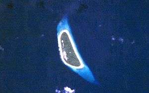
NASA picture of Nama Island
Nama or Nema is an island and municipality in the state of Chuuk, Federated States of Micronesia.[1]
It is a 1.5 km long and 0.5 km wide island part of the Eastern Islands or Upper Mortlock Islands group, located about 60 km to the ESE of Chuuk and 13 km NW of Losap.[2] Nama is densely populated despite its small size. It had 995 inhabitants in the 2000 census.[3]
Climate
Has a Tropical monsoon climate (Köppen climate classification:Aw) that border on a hot desert climate.
| Climate data for Nama | |||||||||||||
|---|---|---|---|---|---|---|---|---|---|---|---|---|---|
| Month | Jan | Feb | Mar | Apr | May | Jun | Jul | Aug | Sep | Oct | Nov | Dec | Year |
| Average high °C (°F) | 32 (90) |
34 (93) |
36 (97) |
37 (99) |
38 (100) |
39 (102) |
40 (104) |
39 (102) |
38 (100) |
36 (97) |
35 (95) |
33 (91) |
36.42 (97.56) |
| Daily mean °C (°F) | 29 (84) |
30 (86) |
34 (93) |
34 (93) |
35 (95) |
38 (100) |
38 (100) |
37 (99) |
36 (97) |
33 (91) |
32 (90) |
29 (84) |
33.75 (92.75) |
| Average low °C (°F) | 26 (79) |
28 (82) |
31 (88) |
32 (90) |
34 (93) |
36 (97) |
36 (97) |
35 (95) |
33 (91) |
30 (86) |
29 (84) |
27 (81) |
31.42 (88.56) |
| Average precipitation mm (inches) | 0 (0) |
0.12 (0.0047) |
1 (0.04) |
0.65 (0.0256) |
55 (2.17) |
218 (8.58) |
320 (12.6) |
165 (6.5) |
25 (0.98) |
2 (0.08) |
0.33 (0.013) |
0.15 (0.0059) |
787.25 (30.9941) |
| Source: Micronesian National Institute of Meteorology | |||||||||||||
References
- ↑ Statoids.com, retrieved December 8, 2010
- ↑ Oceandots - Nama at the Wayback Machine (archived December 23, 2010)
- ↑ Chuuk State Census Report, 2000
External links
Coordinates: 6°59′30″N 152°34′29″E / 6.9918°N 152.5746°E
This article is issued from Wikipedia - version of the 11/13/2016. The text is available under the Creative Commons Attribution/Share Alike but additional terms may apply for the media files.